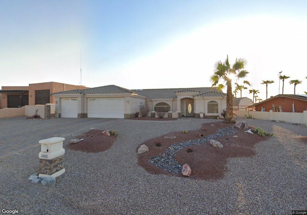
1842 Combat Dr Lake Havasu City, AZ 86403
Estimated Value: $657,000 - $706,000
3
Beds
2
Baths
1,869
Sq Ft
$366/Sq Ft
Est. Value
About This Home
This home is located at 1842 Combat Dr, Lake Havasu City, AZ 86403 and is currently estimated at $684,548, approximately $366 per square foot. 1842 Combat Dr is a home located in Mohave County with nearby schools including Starline Elementary School, Thunderbolt Middle School, and Lake Havasu High School.
Ownership History
Date
Name
Owned For
Owner Type
Purchase Details
Closed on
Jan 23, 2006
Sold by
Raap Harold F and Raap Audrey
Bought by
Raap Harold F and Raap Audrey
Current Estimated Value
Purchase Details
Closed on
Jun 6, 2003
Sold by
Mountain Phil D and Campbell Mountain Marti
Bought by
Everson Michael John
Home Financials for this Owner
Home Financials are based on the most recent Mortgage that was taken out on this home.
Original Mortgage
$168,000
Interest Rate
5.61%
Mortgage Type
New Conventional
Purchase Details
Closed on
Aug 2, 1999
Sold by
Swain Mike and Swain Pamela J
Bought by
Mountain Philip D and Campbell Mountain Marti
Home Financials for this Owner
Home Financials are based on the most recent Mortgage that was taken out on this home.
Original Mortgage
$123,100
Interest Rate
7.56%
Mortgage Type
New Conventional
Create a Home Valuation Report for This Property
The Home Valuation Report is an in-depth analysis detailing your home's value as well as a comparison with similar homes in the area
Home Values in the Area
Average Home Value in this Area
Purchase History
| Date | Buyer | Sale Price | Title Company |
|---|---|---|---|
| Raap Harold F | -- | Transnation Title | |
| Raap Harold F | $450,000 | Transnation Title | |
| Everson Michael John | $240,000 | Capital Title Agency Inc | |
| Mountain Philip D | $153,875 | Transnation Title Ins Co |
Source: Public Records
Mortgage History
| Date | Status | Borrower | Loan Amount |
|---|---|---|---|
| Previous Owner | Everson Michael John | $168,000 | |
| Previous Owner | Mountain Philip D | $123,100 |
Source: Public Records
Tax History Compared to Growth
Tax History
| Year | Tax Paid | Tax Assessment Tax Assessment Total Assessment is a certain percentage of the fair market value that is determined by local assessors to be the total taxable value of land and additions on the property. | Land | Improvement |
|---|---|---|---|---|
| 2026 | -- | -- | -- | -- |
| 2025 | $1,900 | $48,900 | $0 | $0 |
| 2024 | $1,900 | $56,303 | $0 | $0 |
| 2023 | $1,900 | $44,395 | $0 | $0 |
| 2022 | $1,830 | $36,705 | $0 | $0 |
| 2021 | $2,045 | $32,114 | $0 | $0 |
| 2019 | $1,942 | $28,512 | $0 | $0 |
| 2018 | $1,877 | $27,378 | $0 | $0 |
| 2017 | $1,844 | $26,144 | $0 | $0 |
| 2016 | $1,631 | $24,306 | $0 | $0 |
| 2015 | $1,587 | $22,453 | $0 | $0 |
Source: Public Records
Map
Nearby Homes
- 1827 Combat Dr
- 371 Cottonwood Dr
- 220 White Oak Dr
- 1852 Montana Vista Unit B
- 1958 Montana Vista Unit D
- 1840 Montana Vista Unit D
- 1838 Montana Vista Unit C
- 1884 Montana Vista Unit 63B
- 190 Aspen Dr
- 1824 Montana Vista Unit D
- 160 Aspen Dr
- 1711 Combat Dr Unit 12
- 1793 Montana Vista Unit C
- 500 Lake Havasu Ave S Unit A12
- 1723 Montana Vista Unit D
- 1881 Pinion Tree Dr
- 1786 Los Lagos Dr Unit A
- 2041 Oak Dr
- 1771 Los Lagos Dr Unit D
- 1775 Los Lagos Dr Unit B
- 1840 Combat Dr
- 1844 Combat Dr
- 291 White Oak Dr
- 281 White Oak Dr
- 1846 Combat Dr
- 1838 Combat Dr
- 1829 Combat Dr
- 1831 Combat Dr
- 301 White Oak Dr
- 1831 Combat Dr
- 1825 Combat Dr
- 271 White Oak Dr
- 1848 Combat Dr
- 1836 Combat Dr
- 1836 Combat Dr
- 1833 Combat Dr
- 1826 Ambas Dr
- 1823 Combat Dr
- 1828 Ambas Dr
- 1850 Combat Dr