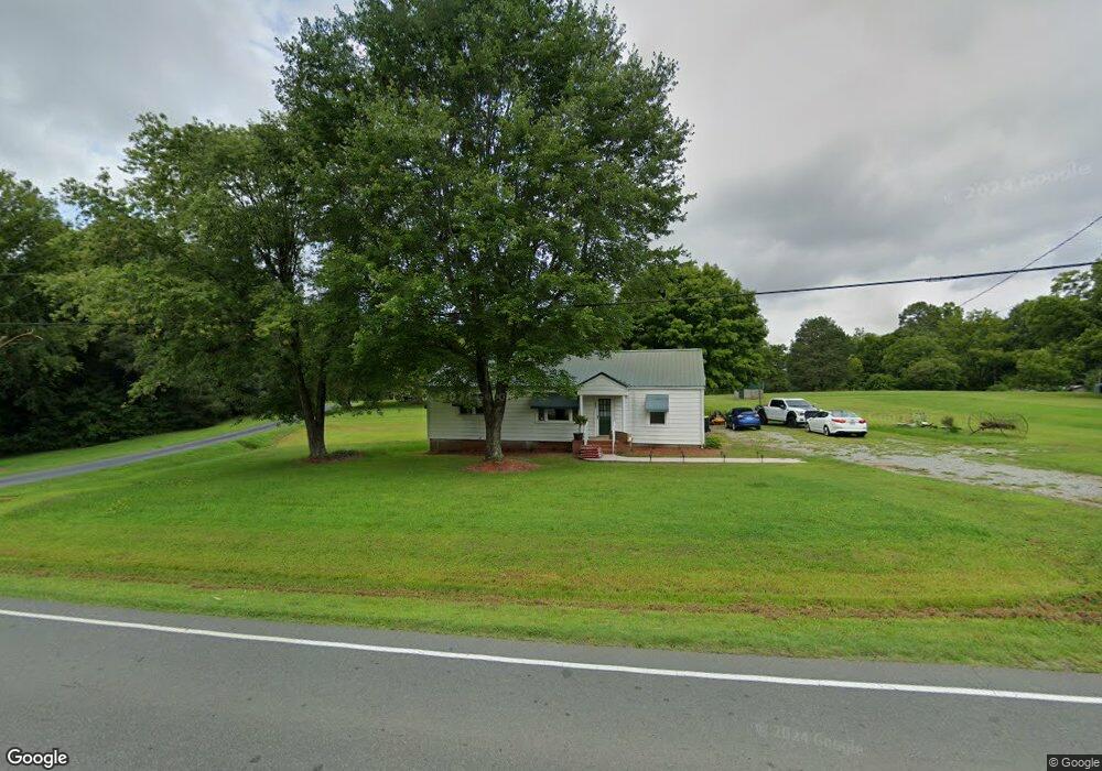
1843 S Main St Graham, NC 27253
Estimated Value: $310,000 - $367,202
3
Beds
2
Baths
1,340
Sq Ft
$256/Sq Ft
Est. Value
About This Home
This home is located at 1843 S Main St, Graham, NC 27253 and is currently estimated at $343,551, approximately $256 per square foot. 1843 S Main St is a home located in Alamance County with nearby schools including South Graham Elementary School, Southern Alamance Middle School, and Southern Alamance High School.
Ownership History
Date
Name
Owned For
Owner Type
Purchase Details
Closed on
Jul 28, 2023
Sold by
Land Acquisition & Dev Svc Llc
Bought by
Valor Ridge Homeowners Association Inc
Current Estimated Value
Purchase Details
Closed on
Oct 5, 2020
Sold by
Williamson Randy C and Williamson Theresa P
Bought by
Windsor Investments Llc
Purchase Details
Closed on
Nov 14, 2018
Sold by
Aldridge Nancy Shepherd and Stallings Stacey Aldridge
Bought by
Williamson Randy C and Williamson Theresa P
Home Financials for this Owner
Home Financials are based on the most recent Mortgage that was taken out on this home.
Original Mortgage
$160,000
Interest Rate
4.7%
Mortgage Type
New Conventional
Purchase Details
Closed on
Jan 1, 1990
Bought by
Aldridge Jane
Create a Home Valuation Report for This Property
The Home Valuation Report is an in-depth analysis detailing your home's value as well as a comparison with similar homes in the area
Home Values in the Area
Average Home Value in this Area
Purchase History
| Date | Buyer | Sale Price | Title Company |
|---|---|---|---|
| Valor Ridge Homeowners Association Inc | -- | Chicago Title | |
| Land Acquisition & Dev Svc Llc | -- | None Listed On Document | |
| Windsor Investments Llc | -- | None Available | |
| Williamson Randy C | $200,000 | Attorney | |
| Aldridge Jane | -- | -- |
Source: Public Records
Mortgage History
| Date | Status | Borrower | Loan Amount |
|---|---|---|---|
| Previous Owner | Land Acquisition & Dev Svc Llc | $0 | |
| Previous Owner | Williamson Randy C | $160,000 |
Source: Public Records
Tax History Compared to Growth
Tax History
| Year | Tax Paid | Tax Assessment Tax Assessment Total Assessment is a certain percentage of the fair market value that is determined by local assessors to be the total taxable value of land and additions on the property. | Land | Improvement |
|---|---|---|---|---|
| 2025 | $1,669 | $301,257 | $124,308 | $176,949 |
| 2024 | $1,594 | $301,257 | $124,308 | $176,949 |
| 2023 | $1,475 | $301,257 | $124,308 | $176,949 |
| 2022 | $1,354 | $183,854 | $112,491 | $71,363 |
| 2021 | $1,372 | $71,363 | $0 | $71,363 |
| 2020 | $1,576 | $208,352 | $136,989 | $71,363 |
| 2019 | $1,583 | $208,352 | $136,989 | $71,363 |
| 2018 | $0 | $208,352 | $136,989 | $71,363 |
| 2017 | $1,396 | $208,352 | $136,989 | $71,363 |
| 2016 | $1,209 | $180,485 | $123,340 | $57,145 |
| 2015 | $1,203 | $180,485 | $123,340 | $57,145 |
| 2014 | $1,124 | $182,165 | $123,340 | $58,825 |
Source: Public Records
Map
Nearby Homes
- 1798 Parham Dr
- 1811 Parham Dr
- 1811 Parham Dr Unit 89
- 101 Kingston Ln
- 1819 Parham Dr Unit Lot 87
- 1819 Parham Dr
- 1787 Parham Dr
- 1823 Parham Dr
- 1823 Parham Dr Unit Lot 86
- 512 Valentine Ct Unit lot 92
- 511 Valentine Ct
- 511 Valentine Ct Unit Lot 106
- 519 Valentine Ct
- 531 Valentine Ct
- 535 Valentine Ct
- 535 Valentine Ct Unit Lot 100
- 2112 Willow Glen Dr
- 2114 Willow Glen Dr
- Somerset 3 Plan at Valor Ridge
- Cameron Plan at Valor Ridge