
Seller's Agent in 2025
Carole Stencil
Berkshire Hathaway HomeServices Homesale Realty
(410) 977-7179
28 Total Sales
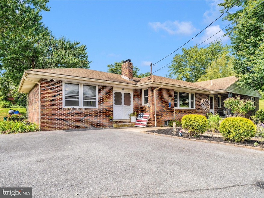


Welcome Home! Escape to the simplicity of country living on this picturesque 4 acre farmette perfectly equipped for hobby farming, homesteading, or simply enjoying open space and fresh air. Enjoy main level living is this 4 Bedroom, 2 1/2 Bath Rancher with nicely sized rooms. The spacious Living Room and Kitchen are open and great for entertaining. The Living Room features a brick fireplace with an insert, wood flooring and a large picture window. It's perfect for the family and great for large gatherings. The kitchen has white cabinets and stainless appliances. The main level also includes 3 spacious bedrooms, a 7X20 breezeway and a 4th bedroom that could be used as a family room. The property sits on over 4 acres and includes a 40X60 Pole Barn with electric. It also includes a full bathroom and an upper level for storage. It's ideal for equipment, a garage or workshop. Outside you will also find a 3 stall barn, a chicken coop (the chickens can stay). The property is conveniently located with easy access to major routes, restaurants and entertainment. Whether you're looking to live sustainably, start a small farm, or just savor a slower pace of life, this special property offers the charm of rural living and just a short drive from town. Come see what makes this farmette a rare and inviting retreat!
Last Agent to Sell the Property
(410) 876-3500 cstencil@cbmove.com Berkshire Hathaway HomeServices Homesale Realty License #70167 Listed on: 08/30/2025
| Date | Type | Sale Price | Title Company |
|---|---|---|---|
| Deed | $525,000 | First American Title Insurance | |
| Interfamily Deed Transfer | -- | None Available | |
| Deed | $198,000 | -- | |
| Deed | $170,000 | -- | |
| Deed | $149,900 | -- |
| Date | Status | Loan Amount | Loan Type |
|---|---|---|---|
| Open | $420,000 | New Conventional |
| Date | Event | Price | List to Sale | Price per Sq Ft |
|---|---|---|---|---|
| 10/10/2025 10/10/25 | Sold | $525,000 | -2.8% | $291 / Sq Ft |
| 09/03/2025 09/03/25 | Pending | -- | -- | -- |
| 08/30/2025 08/30/25 | For Sale | $540,000 | -- | $299 / Sq Ft |
| Year | Tax Paid | Tax Assessment Tax Assessment Total Assessment is a certain percentage of the fair market value that is determined by local assessors to be the total taxable value of land and additions on the property. | Land | Improvement |
|---|---|---|---|---|
| 2025 | $4,255 | $377,600 | $155,300 | $222,300 |
| 2024 | $4,060 | $359,800 | $0 | $0 |
| 2023 | $3,872 | $342,000 | $0 | $0 |
| 2022 | $3,690 | $324,200 | $155,300 | $168,900 |
| 2021 | $7,496 | $321,067 | $0 | $0 |
| 2020 | $3,653 | $317,933 | $0 | $0 |
| 2019 | $3,617 | $314,800 | $155,300 | $159,500 |
| 2018 | $3,585 | $314,800 | $155,300 | $159,500 |
| 2017 | $3,585 | $314,800 | $0 | $0 |
| 2016 | -- | $323,700 | $0 | $0 |
| 2015 | -- | $323,700 | $0 | $0 |
| 2014 | -- | $323,700 | $0 | $0 |
Seller's Agent in 2025
Carole Stencil
Berkshire Hathaway HomeServices Homesale Realty
(410) 977-7179
28 Total Sales
Buyer's Agent in 2025
Jeffrey Morsberger
Corner House Realty
(443) 277-1362
53 Total Sales
Source: Bright MLS
MLS Number: MDCR2028466
APN: 06-022316
Disclaimer: Certain information contained herein is derived from information provided by parties other than Homes.com. All information provided is deemed reliable, but is not guaranteed to be accurate and should be independently verified.
![]() The data relating to real estate for sale on this website appears in part through the BRIGHT Internet Data Exchange program, a voluntary cooperative exchange of property listing data between licensed real estate brokerage firms, and is provided by BRIGHT through a licensing agreement.
The data relating to real estate for sale on this website appears in part through the BRIGHT Internet Data Exchange program, a voluntary cooperative exchange of property listing data between licensed real estate brokerage firms, and is provided by BRIGHT through a licensing agreement.
Listing information is from various brokers who participate in the Bright MLS IDX program and not all listings may be visible on the site.
The property information being provided on or through the website is for the personal, non-commercial use of consumers and such information may not be used for any purpose other than to identify prospective properties consumers may be interested in purchasing.
Some properties which appear for sale on the website may no longer be available because they are for instance, under contract, sold or are no longer being offered for sale.
Property information displayed is deemed reliable but is not guaranteed.
Copyright 2026 Bright MLS, Inc.
Ask me questions while you tour the home.