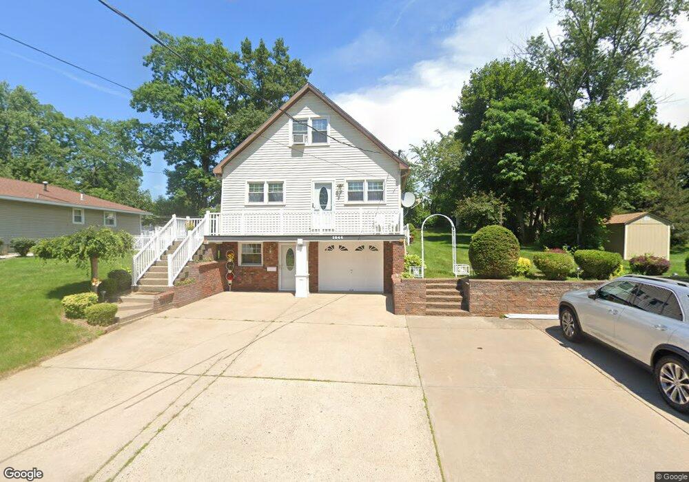
1844 Fiero Ave Schenectady, NY 12303
Estimated Value: $286,296 - $314,000
3
Beds
2
Baths
1,538
Sq Ft
$195/Sq Ft
Est. Value
About This Home
This home is located at 1844 Fiero Ave, Schenectady, NY 12303 and is currently estimated at $300,574, approximately $195 per square foot. 1844 Fiero Ave is a home located in Schenectady County with nearby schools including Herman L Bradt Elementary School, Pinewood Elementary School, and Draper Middle School.
Ownership History
Date
Name
Owned For
Owner Type
Purchase Details
Closed on
Jun 10, 2009
Sold by
Butt Arshad
Bought by
Butt Arshad M and Arshad Samina
Current Estimated Value
Purchase Details
Closed on
Mar 2, 2005
Sold by
Grassia Paul
Bought by
Butt Arshad
Home Financials for this Owner
Home Financials are based on the most recent Mortgage that was taken out on this home.
Original Mortgage
$161,000
Outstanding Balance
$81,893
Interest Rate
5.66%
Mortgage Type
New Conventional
Estimated Equity
$218,681
Create a Home Valuation Report for This Property
The Home Valuation Report is an in-depth analysis detailing your home's value as well as a comparison with similar homes in the area
Home Values in the Area
Average Home Value in this Area
Purchase History
| Date | Buyer | Sale Price | Title Company |
|---|---|---|---|
| Butt Arshad M | -- | None Available | |
| Butt Arshad | $170,000 | William P Bates Esq |
Source: Public Records
Mortgage History
| Date | Status | Borrower | Loan Amount |
|---|---|---|---|
| Open | Butt Arshad | $161,000 |
Source: Public Records
Tax History Compared to Growth
Tax History
| Year | Tax Paid | Tax Assessment Tax Assessment Total Assessment is a certain percentage of the fair market value that is determined by local assessors to be the total taxable value of land and additions on the property. | Land | Improvement |
|---|---|---|---|---|
| 2024 | $5,222 | $170,000 | $9,000 | $161,000 |
| 2023 | $5,222 | $170,000 | $9,000 | $161,000 |
| 2022 | $6,281 | $170,000 | $9,000 | $161,000 |
| 2021 | $6,112 | $170,000 | $9,000 | $161,000 |
| 2020 | $4,876 | $170,000 | $9,000 | $161,000 |
| 2019 | $2,165 | $170,000 | $9,000 | $161,000 |
| 2018 | $2,608 | $170,000 | $9,000 | $161,000 |
| 2017 | $4,688 | $170,000 | $9,000 | $161,000 |
| 2016 | $4,669 | $170,000 | $9,000 | $161,000 |
| 2015 | -- | $170,000 | $10,300 | $159,700 |
| 2014 | -- | $170,000 | $10,300 | $159,700 |
Source: Public Records
Map
Nearby Homes
- 882 Obrien Ave
- 1120 Outer Dr
- 1074 Palazini Dr
- 1105 Outer Dr
- 2020 Greenpoint Ave
- 1710 Norfolk Ave
- 1729 Elizabeth St
- 1049 Helen St
- 1076 Outer Dr
- 1841 Tower St
- 2116 Ferguson St
- 1013 Inner Dr
- 2092 Chepstow Rd
- 1001 Kingswood Ct
- 1094 Roberta Rd
- L1 Fort Hunter Rd
- 1221 Houlton Ave
- 1037 Roberta Rd
- 1976 Curry Rd Unit E-136
- 2137 van Wormer Rd
- 1834 Fiero Ave
- 1854 Fiero Ave
- 1864 Fiero Ave
- 927 Obrien Ave
- 1832 Fiero Ave
- 931 Obrien Ave
- 923 Obrien Ave
- 1865 Fiero Ave
- 1857 Fiero Ave
- 1849 Fiero Ave
- 1828 Fiero Ave
- 919 Obrien Ave
- 1877 Fiero Ave
- 1841 Fiero Ave
- 939 Obrien Ave
- 0 Fiero Ave Unit 201316858
- 0 Fiero Ave Unit 201316857
- 1820 Fiero Ave
- 1888 Fiero Ave
- 1086 Deforest Ave