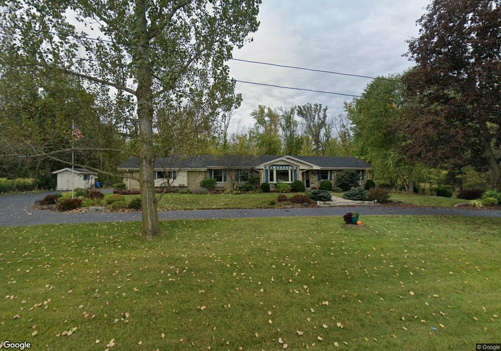
1845 Sherman Rd Jackson, WI 53037
Estimated Value: $547,000 - $618,000
4
Beds
3
Baths
2,199
Sq Ft
$266/Sq Ft
Est. Value
About This Home
This home is located at 1845 Sherman Rd, Jackson, WI 53037 and is currently estimated at $585,162, approximately $266 per square foot. 1845 Sherman Rd is a home located in Washington County with nearby schools including Rockfield Elementary School, Kennedy Middle School, and Germantown High School.
Ownership History
Date
Name
Owned For
Owner Type
Purchase Details
Closed on
Dec 21, 2015
Sold by
Sierra Janis J and Sierra Patrick M
Bought by
Sierra Janis J and Revo Patrick
Current Estimated Value
Purchase Details
Closed on
Jan 11, 2007
Sold by
Boerger Thomas and Boerger Thomas Jo
Bought by
Sierra Patrick M and Sierra Janis J
Home Financials for this Owner
Home Financials are based on the most recent Mortgage that was taken out on this home.
Original Mortgage
$192,000
Interest Rate
6.21%
Mortgage Type
New Conventional
Create a Home Valuation Report for This Property
The Home Valuation Report is an in-depth analysis detailing your home's value as well as a comparison with similar homes in the area
Home Values in the Area
Average Home Value in this Area
Purchase History
| Date | Buyer | Sale Price | Title Company |
|---|---|---|---|
| Sierra Janis J | -- | None Available | |
| Sierra Patrick M | $330,000 | None Available |
Source: Public Records
Mortgage History
| Date | Status | Borrower | Loan Amount |
|---|---|---|---|
| Previous Owner | Sierra Patrick M | $192,000 |
Source: Public Records
Tax History
| Year | Tax Paid | Tax Assessment Tax Assessment Total Assessment is a certain percentage of the fair market value that is determined by local assessors to be the total taxable value of land and additions on the property. | Land | Improvement |
|---|---|---|---|---|
| 2025 | $5,359 | $392,800 | $86,900 | $305,900 |
| 2024 | $4,744 | $392,800 | $86,900 | $305,900 |
| 2023 | $4,347 | $392,800 | $86,900 | $305,900 |
| 2022 | $4,184 | $392,800 | $86,900 | $305,900 |
| 2021 | $4,299 | $313,800 | $79,200 | $234,600 |
| 2020 | $5,064 | $313,800 | $79,200 | $234,600 |
| 2019 | $4,662 | $313,800 | $79,200 | $234,600 |
| 2018 | $4,475 | $313,800 | $79,200 | $234,600 |
| 2017 | $4,117 | $297,400 | $74,800 | $222,600 |
| 2016 | $4,078 | $297,400 | $74,800 | $222,600 |
| 2015 | $4,157 | $297,400 | $74,800 | $222,600 |
| 2014 | $4,157 | $297,400 | $74,800 | $222,600 |
| 2013 | $4,482 | $297,400 | $74,800 | $222,600 |
Source: Public Records
Map
Nearby Homes
- 1829 W Mill Rd
- N160W18903 Oakland Dr
- N161W18890 Jared Dr Unit 251
- W190N15716 Maple Fields Cir
- N156W19271 E Gate Dr
- W219N16270 Primrose Ct
- W219N16267 Primrose Ct
- W219N16248 Primrose Ct
- N156W19385 E Gate Dr
- N156W19431 E Gate Dr
- W196N16501 Hawthorn Dr
- N166W19782 Jackson Oaks Dr
- N166W19796 Jackson Oaks Dr
- N166W19840 Jackson Oaks Dr
- N166W19802 Jackson Oaks Dr
- N166W19890 Jackson Oaks Dr
- N166W19820 Jackson Oaks Dr
- W203N16198 Pin Oak Cir Unit 2
- W203N16184 Pin Oak Cir
- N167W19729 Spruce St Unit 12A
- 1818 Sherman Rd
- 1796 Sherman Rd
- 1782 Sherman Rd
- 1876 Sherman Rd
- 1780 Margaret Ct
- 1777 Margaret Ct
- 1765 Margaret Ct
- 1752 Sherman Rd
- 1930 Sherman Rd
- 1736 Margaret Ct
- 1721 Margaret Ct
- 1732 Sherman Rd
- 1966 Sherman Rd
- 1727 Monticello Rd
- 1750 Monticello Rd
- 1718 Monticello Rd
- 1710 Sherman Rd
- 1736 Monticello Rd
- 1986 Sherman Rd
- 1997 Sherman Rd
Your Personal Tour Guide
Ask me questions while you tour the home.