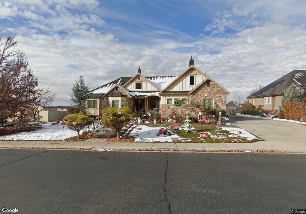
1849 N 275 E Unit 9 Pleasant Grove, UT 84062
Estimated Value: $1,097,000 - $1,503,589
3
Beds
5
Baths
2,954
Sq Ft
$434/Sq Ft
Est. Value
About This Home
This home is located at 1849 N 275 E Unit 9, Pleasant Grove, UT 84062 and is currently estimated at $1,280,897, approximately $433 per square foot. 1849 N 275 E Unit 9 is a home located in Utah County with nearby schools including Manila Elementary School, Pleasant Grove Junior High School, and Pleasant Grove High School.
Ownership History
Date
Name
Owned For
Owner Type
Purchase Details
Closed on
Nov 16, 2023
Sold by
Huntsman Larry and Huntsman Patricia
Bought by
Larry & Patricia Huntsman Family Trust and Huntsman
Current Estimated Value
Purchase Details
Closed on
May 7, 2012
Sold by
Lorscheider Michael H and Lorscheider Carol Ann
Bought by
Huntsman Larry and Huntsman Patricia
Purchase Details
Closed on
Jun 16, 2011
Sold by
Belmont Estates Llc
Bought by
Lorscheider Michael H and Lorscheider Carol Ann
Create a Home Valuation Report for This Property
The Home Valuation Report is an in-depth analysis detailing your home's value as well as a comparison with similar homes in the area
Home Values in the Area
Average Home Value in this Area
Purchase History
| Date | Buyer | Sale Price | Title Company |
|---|---|---|---|
| Larry & Patricia Huntsman Family Trust | -- | Prospect Title | |
| Huntsman Larry | -- | None Available | |
| Lorscheider Michael H | -- | Empire Land Title Inc |
Source: Public Records
Tax History Compared to Growth
Tax History
| Year | Tax Paid | Tax Assessment Tax Assessment Total Assessment is a certain percentage of the fair market value that is determined by local assessors to be the total taxable value of land and additions on the property. | Land | Improvement |
|---|---|---|---|---|
| 2025 | $5,804 | $741,290 | $426,400 | $921,400 |
| 2024 | $5,804 | $692,780 | $0 | $0 |
| 2023 | $5,724 | $699,380 | $0 | $0 |
| 2022 | $5,703 | $693,330 | $0 | $0 |
| 2021 | $4,936 | $913,700 | $242,600 | $671,100 |
| 2020 | $4,662 | $846,000 | $224,600 | $621,400 |
| 2019 | $4,415 | $828,500 | $208,500 | $620,000 |
| 2018 | $4,133 | $733,300 | $192,500 | $540,800 |
| 2017 | $3,872 | $365,750 | $0 | $0 |
| 2016 | $3,665 | $334,235 | $0 | $0 |
| 2015 | $3,768 | $325,435 | $0 | $0 |
| 2014 | $3,448 | $295,020 | $0 | $0 |
Source: Public Records
Map
Nearby Homes
- 429 E 1600 N
- 1726 N Siena Cir Unit 10
- 1727 N Siena Cir Unit 4
- 1656 N Siena Cir Unit 7
- 532 W 2000 N
- 1152 N 200 W
- 8905 N Pine Hollow Dr
- 1051 N 600 W
- 1031 N 600 W
- 1041 N 600 W
- 8944 Silver Lake Dr
- 731 W 1590 N Unit 15
- 3373 Bear Canyon Ln
- 8923 N Cottage Canyon Dr
- 1534 N 750 W Unit 16
- 674 W 1590 N Unit 11
- 344 E 900 N
- Konlee Plan at Makin Dreams
- Alexa Plan at Makin Dreams
- Callahan Plan at Makin Dreams
- 1849 N 275 E
- 1817 N 275 E
- 1817 N 275 E Unit 8
- 1881 N 275 E Unit 10
- 1856 N 230 E
- 1856 N 230 E Unit 6
- 1824 N 230 E Unit 7
- 1824 N 230 E
- 1848 N 275 E Unit 12
- 1898 N 230 E
- 1898 N 230 E Unit 5
- 1818 N 275 E
- 1818 N 275 E Unit 13
- 1882 N 275 E
- 1882 N 275 E Unit 11
- 275 E Murdock Dr Unit 8
- 247 E 1920 N
- 1845 N 320 E
- 1845 N 320 E Unit 15
- 1855 N 230 E Unit 3