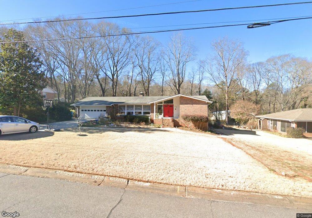
185 Devonshire Dr Athens, GA 30606
Saint George Place NeighborhoodEstimated Value: $335,000 - $511,000
4
Beds
3
Baths
2,562
Sq Ft
$161/Sq Ft
Est. Value
About This Home
This home is located at 185 Devonshire Dr, Athens, GA 30606 and is currently estimated at $411,972, approximately $160 per square foot. 185 Devonshire Dr is a home located in Clarke County with nearby schools including Timothy Elementary School, Clarke Middle School, and Clarke Central High School.
Ownership History
Date
Name
Owned For
Owner Type
Purchase Details
Closed on
Dec 5, 2011
Sold by
Moreland John A
Bought by
Stuck Regina Fritzsche
Current Estimated Value
Home Financials for this Owner
Home Financials are based on the most recent Mortgage that was taken out on this home.
Original Mortgage
$120,000
Outstanding Balance
$81,687
Interest Rate
4.06%
Mortgage Type
New Conventional
Estimated Equity
$330,285
Create a Home Valuation Report for This Property
The Home Valuation Report is an in-depth analysis detailing your home's value as well as a comparison with similar homes in the area
Home Values in the Area
Average Home Value in this Area
Purchase History
| Date | Buyer | Sale Price | Title Company |
|---|---|---|---|
| Stuck Regina Fritzsche | $160,000 | -- |
Source: Public Records
Mortgage History
| Date | Status | Borrower | Loan Amount |
|---|---|---|---|
| Open | Stuck Regina Fritzsche | $120,000 |
Source: Public Records
Tax History
| Year | Tax Paid | Tax Assessment Tax Assessment Total Assessment is a certain percentage of the fair market value that is determined by local assessors to be the total taxable value of land and additions on the property. | Land | Improvement |
|---|---|---|---|---|
| 2025 | $2,243 | $119,337 | $20,000 | $99,337 |
| 2024 | $2,243 | $118,546 | $20,000 | $98,546 |
| 2023 | $1,042 | $112,212 | $20,000 | $92,212 |
| 2022 | $2,237 | $97,051 | $16,000 | $81,051 |
| 2021 | $2,119 | $79,487 | $12,000 | $67,487 |
| 2020 | $2,057 | $74,986 | $12,000 | $62,986 |
| 2019 | $2,027 | $71,710 | $12,000 | $59,710 |
| 2018 | $2,320 | $68,328 | $12,000 | $56,328 |
| 2017 | $0 | $66,942 | $12,000 | $54,942 |
| 2016 | $2,088 | $61,513 | $11,200 | $50,313 |
| 2015 | $1,986 | $58,398 | $11,200 | $47,198 |
| 2014 | $1,995 | $58,600 | $11,200 | $47,400 |
Source: Public Records
Map
Nearby Homes
- 255 Pine Valley Dr
- 1720 Timothy Rd
- 132 Branford Place
- 210 Pine Valley Dr
- 220 Tanglewood Dr
- 255 Plum Nelly Rd
- 160 Pine Valley Dr
- 130 Wexford Place
- 199 Tanglewood Dr
- 550 Fortson Rd
- 190 Bowles Dr Unit 1
- 190 Bowles Dr
- 205 Heritage Stroll
- 665 W Lake Dr
- 134 Tanner Bluff
- 50 Pine Valley Dr
- 200 Skyline Pkwy
- 236 Towns Walk Dr
- 176 Towns Walk Dr
- 107 Beacham Dr
- 240 Devonshire Dr
- 175 Devonshire Dr
- 195 Devonshire Dr
- 180 Saint James Dr
- 170 Saint James Dr
- 180 Devonshire Dr
- 165 Devonshire Dr
- 400 Somerset Dr
- 160 Devonshire Dr
- 205 Devonshire Dr
- 150 Saint James Dr
- 155 Devonshire Dr
- 200 Devonshire Dr
- 430 Somerset Dr
- 190 Saint James Dr
- 185 Saint James Dr
- 140 Devonshire Dr
- 175 Saint James Dr
- 375 Somerset Dr
- 195 Saint James Dr
Your Personal Tour Guide
Ask me questions while you tour the home.