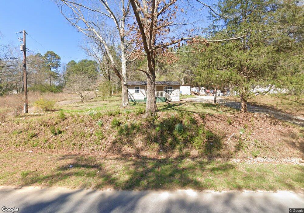
185 Friendship Rd Cedartown, GA 30125
Estimated Value: $91,059 - $235,000
2
Beds
1
Bath
672
Sq Ft
$231/Sq Ft
Est. Value
About This Home
This home is located at 185 Friendship Rd, Cedartown, GA 30125 and is currently estimated at $155,515, approximately $231 per square foot. 185 Friendship Rd is a home located in Polk County with nearby schools including Cedar Christian School.
Ownership History
Date
Name
Owned For
Owner Type
Purchase Details
Closed on
Feb 5, 2015
Sold by
Anderson Roy
Bought by
Welchel Charles E
Current Estimated Value
Purchase Details
Closed on
Sep 26, 1978
Sold by
Carter Bernice B
Bought by
Anderson Roy Lee
Purchase Details
Closed on
Mar 20, 1973
Sold by
Mid State Homes Inc
Bought by
Carter Bernice B
Purchase Details
Closed on
Dec 7, 1972
Sold by
Barker Micheal
Bought by
Mid State Homes Inc
Purchase Details
Closed on
Jun 8, 1972
Sold by
Meeks Larry
Bought by
Barker Micheal
Purchase Details
Closed on
Nov 22, 1968
Bought by
Meeks Larry
Create a Home Valuation Report for This Property
The Home Valuation Report is an in-depth analysis detailing your home's value as well as a comparison with similar homes in the area
Home Values in the Area
Average Home Value in this Area
Purchase History
| Date | Buyer | Sale Price | Title Company |
|---|---|---|---|
| Welchel Charles E | $16,000 | -- | |
| Anderson Roy Lee | -- | -- | |
| Carter Bernice B | -- | -- | |
| Mid State Homes Inc | -- | -- | |
| Barker Micheal | -- | -- | |
| Meeks Larry | -- | -- |
Source: Public Records
Tax History Compared to Growth
Tax History
| Year | Tax Paid | Tax Assessment Tax Assessment Total Assessment is a certain percentage of the fair market value that is determined by local assessors to be the total taxable value of land and additions on the property. | Land | Improvement |
|---|---|---|---|---|
| 2024 | $411 | $19,665 | $1,535 | $18,130 |
| 2023 | $304 | $12,825 | $1,535 | $11,290 |
| 2022 | $252 | $10,608 | $1,023 | $9,585 |
| 2021 | $255 | $10,608 | $1,023 | $9,585 |
| 2020 | $256 | $10,608 | $1,023 | $9,585 |
| 2019 | $142 | $5,291 | $1,023 | $4,268 |
| 2018 | $142 | $5,145 | $1,023 | $4,122 |
| 2017 | $140 | $5,145 | $1,023 | $4,122 |
| 2016 | $56 | $5,206 | $1,084 | $4,122 |
| 2015 | $144 | $5,279 | $1,084 | $4,195 |
| 2014 | $145 | $5,279 | $1,084 | $4,195 |
Source: Public Records
Map
Nearby Homes
- 151 Friendship Rd
- 0 Mountain Home Rd Unit 1020-C 10351948
- 0 Mountain Home Rd Unit 1020-B 10351940
- 0 Mountain Home Rd Unit 1020-A 10351930
- 119 New Harmony Rd
- 255 Reynolds Rd
- 516 Branch St
- 512 Branch St
- 508 Branch St
- 382 5th St
- 39 Summerwind Dr
- 293 4th St
- 28 Summerwind Dr
- 1849 Prior Station Rd Unit 76 ACRES
- 1849 Prior Station Rd
- 1200 N Cave Spring St
- 35 Harris Loop
- 605 W Girard Ave
- 309 Walnut St
- 195 Friendship Rd
- 157 Friendship Rd
- 179 Friendship Rd
- 160 Friendship Rd
- 230 Friendship Rd
- 135 Friendship Rd
- 248 Friendship Rd
- 229 Friendship Rd
- 275 Friendship Rd
- 100 Friendship Rd
- 284 Friendship Rd
- 84 Friendship Rd
- 56 Friendship Rd
- 54 Friendship Rd
- 277 Friendship Rd
- 288 Mountain Home Rd
- 272 Mountain Home Rd
- 260 Mountain Home Rd
- 16 Friendship Rd
- 367 Friendship Rd