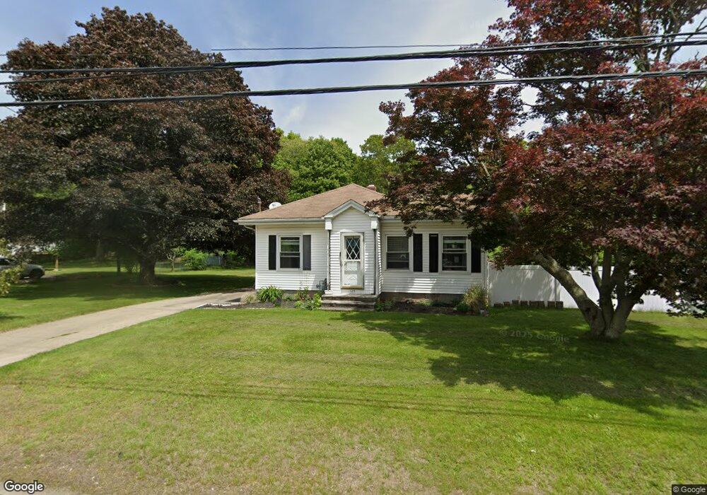
185 Liberty St Pawcatuck, CT 06379
Estimated Value: $339,000 - $348,000
3
Beds
2
Baths
1,128
Sq Ft
$305/Sq Ft
Est. Value
About This Home
This home is located at 185 Liberty St, Pawcatuck, CT 06379 and is currently estimated at $344,336, approximately $305 per square foot. 185 Liberty St is a home located in New London County with nearby schools including Stonington Middle School, Stonington High School, and North Stonington Christian Academy.
Ownership History
Date
Name
Owned For
Owner Type
Purchase Details
Closed on
Feb 11, 2022
Sold by
Shalloo Richard J and Shalloo Sharon E
Bought by
Discuillo Joan
Current Estimated Value
Home Financials for this Owner
Home Financials are based on the most recent Mortgage that was taken out on this home.
Original Mortgage
$196,000
Outstanding Balance
$180,279
Interest Rate
3.56%
Mortgage Type
Purchase Money Mortgage
Estimated Equity
$164,057
Purchase Details
Closed on
Oct 2, 2003
Sold by
Colechia Glenn
Bought by
Shalloo Richard and Shalloo Sharon
Home Financials for this Owner
Home Financials are based on the most recent Mortgage that was taken out on this home.
Original Mortgage
$136,000
Interest Rate
6.25%
Mortgage Type
Purchase Money Mortgage
Create a Home Valuation Report for This Property
The Home Valuation Report is an in-depth analysis detailing your home's value as well as a comparison with similar homes in the area
Home Values in the Area
Average Home Value in this Area
Purchase History
| Date | Buyer | Sale Price | Title Company |
|---|---|---|---|
| Discuillo Joan | $245,000 | None Available | |
| Discuillo Joan | $245,000 | None Available | |
| Shalloo Richard | $170,000 | -- | |
| Shalloo Richard | $170,000 | -- |
Source: Public Records
Mortgage History
| Date | Status | Borrower | Loan Amount |
|---|---|---|---|
| Open | Discuillo Joan | $196,000 | |
| Closed | Discuillo Joan | $196,000 | |
| Previous Owner | Shalloo Richard | $110,000 | |
| Previous Owner | Shalloo Richard | $136,000 |
Source: Public Records
Tax History
| Year | Tax Paid | Tax Assessment Tax Assessment Total Assessment is a certain percentage of the fair market value that is determined by local assessors to be the total taxable value of land and additions on the property. | Land | Improvement |
|---|---|---|---|---|
| 2025 | $3,461 | $174,100 | $50,200 | $123,900 |
| 2024 | $3,317 | $174,100 | $50,200 | $123,900 |
| 2023 | $3,317 | $174,100 | $50,200 | $123,900 |
| 2022 | $3,199 | $124,900 | $44,300 | $80,600 |
| 2021 | $3,288 | $128,200 | $44,300 | $83,900 |
| 2020 | $3,226 | $128,200 | $44,300 | $83,900 |
| 2019 | $3,219 | $128,200 | $44,300 | $83,900 |
| 2018 | $2,889 | $119,100 | $44,300 | $74,800 |
| 2017 | $2,684 | $109,000 | $41,600 | $67,400 |
| 2016 | $2,611 | $109,000 | $41,600 | $67,400 |
| 2015 | $2,450 | $109,000 | $41,600 | $67,400 |
| 2014 | $2,397 | $109,000 | $41,600 | $67,400 |
Source: Public Records
Map
Nearby Homes
Your Personal Tour Guide
Ask me questions while you tour the home.