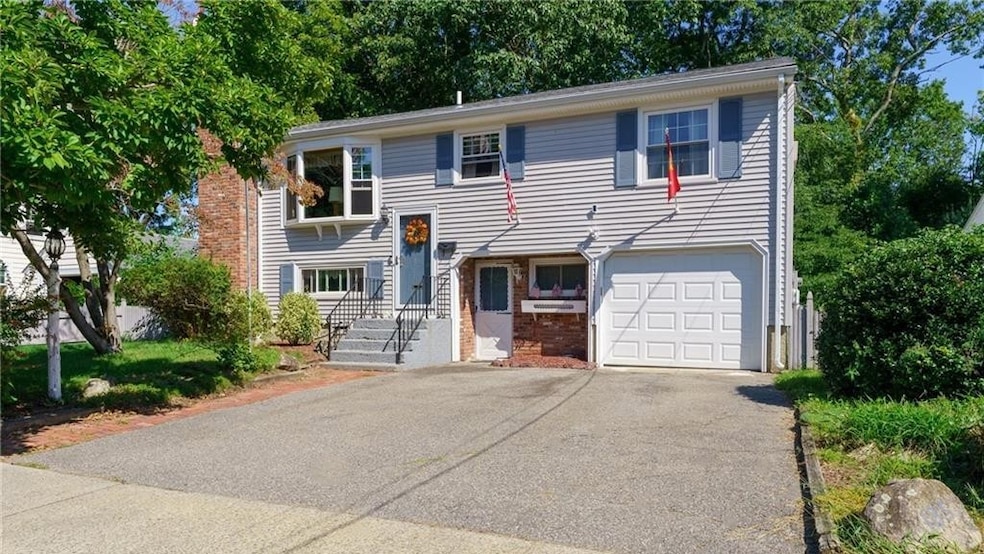
185 Parkside Ave Pawtucket, RI 02861
Darlington NeighborhoodEstimated payment $2,611/month
Highlights
- Golf Course Community
- Deck
- Wood Flooring
- River Access
- Raised Ranch Architecture
- Attic
About This Home
SOLD BEFORE PRINT.

Home Details
Home Type
- Single Family
Est. Annual Taxes
- $4,896
Year Built
- Built in 1970
Home Design
- Raised Ranch Architecture
- Vinyl Siding
- Concrete Perimeter Foundation
Interior Spaces
- 2-Story Property
- 2 Fireplaces
- Fireplace Features Masonry
- Thermal Windows
- Family Room
- Storm Doors
- Attic
Kitchen
- Oven
- Range
- Microwave
- Dishwasher
Flooring
- Wood
- Carpet
- Ceramic Tile
- Vinyl
Bedrooms and Bathrooms
- 3 Bedrooms
- 2 Full Bathrooms
- Bathtub with Shower
Laundry
- Laundry Room
- Dryer
- Washer
Partially Finished Basement
- Basement Fills Entire Space Under The House
- Interior and Exterior Basement Entry
Parking
- 2 Parking Spaces
- No Garage
- Driveway
Outdoor Features
- River Access
- Walking Distance to Water
- Deck
- Patio
- Outdoor Grill
Utilities
- Ductless Heating Or Cooling System
- Cooling System Mounted In Outer Wall Opening
- Heating System Uses Gas
- Baseboard Heating
- Hot Water Heating System
- Gas Water Heater
Additional Features
- 6,000 Sq Ft Lot
- Property near a hospital
Listing and Financial Details
- Tax Lot 0419
- Assessor Parcel Number 185PARKSIDEAVPAWT
Community Details
Overview
- Darlington / Slater Park Subdivision
Amenities
- Shops
- Restaurant
- Public Transportation
Recreation
- Golf Course Community
- Tennis Courts
- Recreation Facilities
Map
Home Values in the Area
Average Home Value in this Area
Tax History
| Year | Tax Paid | Tax Assessment Tax Assessment Total Assessment is a certain percentage of the fair market value that is determined by local assessors to be the total taxable value of land and additions on the property. | Land | Improvement |
|---|---|---|---|---|
| 2025 | $4,897 | $372,400 | $166,800 | $205,600 |
| 2024 | $4,595 | $372,400 | $166,800 | $205,600 |
| 2023 | $4,428 | $261,400 | $100,900 | $160,500 |
| 2022 | $4,334 | $261,400 | $100,900 | $160,500 |
| 2021 | $4,334 | $261,400 | $100,900 | $160,500 |
| 2020 | $4,788 | $229,200 | $103,000 | $126,200 |
| 2019 | $4,788 | $229,200 | $103,000 | $126,200 |
| 2018 | $4,614 | $229,200 | $103,000 | $126,200 |
| 2017 | $4,149 | $182,600 | $78,100 | $104,500 |
| 2016 | $3,997 | $182,600 | $78,100 | $104,500 |
| 2015 | $3,997 | $182,600 | $78,100 | $104,500 |
| 2014 | $4,211 | $182,600 | $78,100 | $104,500 |
Property History
| Date | Event | Price | List to Sale | Price per Sq Ft |
|---|---|---|---|---|
| 12/08/2025 12/08/25 | Pending | -- | -- | -- |
| 12/08/2025 12/08/25 | For Sale | $420,000 | -- | $204 / Sq Ft |
Purchase History
| Date | Type | Sale Price | Title Company |
|---|---|---|---|
| Quit Claim Deed | -- | -- | |
| Warranty Deed | $104,000 | -- | |
| Warranty Deed | $85,000 | -- |
Mortgage History
| Date | Status | Loan Amount | Loan Type |
|---|---|---|---|
| Previous Owner | $66,400 | No Value Available | |
| Previous Owner | $292,858 | No Value Available | |
| Previous Owner | $189,472 | No Value Available |
Source: State-Wide MLS
MLS Number: 1401439
APN: PAWT-000015-000000-000419
Disclaimer: Certain information contained herein is derived from information provided by parties other than Homes.com. All information provided is deemed reliable, but is not guaranteed to be accurate and should be independently verified.
![]() IDX information is provided exclusively for personal, non-commercial use, and may not be used for any purpose other than to identify prospective properties consumers may be interested in purchasing. Information is deemed reliable but not guaranteed.
IDX information is provided exclusively for personal, non-commercial use, and may not be used for any purpose other than to identify prospective properties consumers may be interested in purchasing. Information is deemed reliable but not guaranteed.
Copyright © 2025 State-Wide MLS, Inc. All rights reserved.