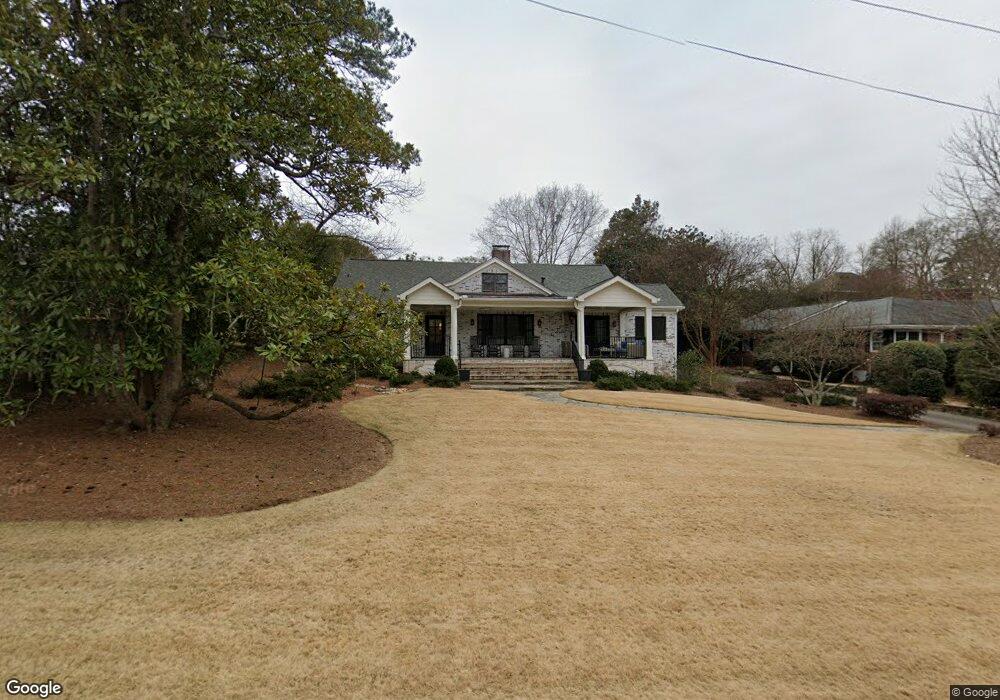
185 Rock Glenn Rd Athens, GA 30606
Five Points NeighborhoodEstimated Value: $1,214,000 - $1,403,000
--
Bed
1
Bath
3,712
Sq Ft
$349/Sq Ft
Est. Value
About This Home
This home is located at 185 Rock Glenn Rd, Athens, GA 30606 and is currently estimated at $1,294,910, approximately $348 per square foot. 185 Rock Glenn Rd is a home located in Clarke County with nearby schools including Barrow Elementary School, Clarke Middle School, and Clarke Central High School.
Ownership History
Date
Name
Owned For
Owner Type
Purchase Details
Closed on
Jun 18, 2015
Sold by
Lewis Edward Eugene
Bought by
Atkinson Lee Shafter and Atkinson Lucy R
Current Estimated Value
Home Financials for this Owner
Home Financials are based on the most recent Mortgage that was taken out on this home.
Original Mortgage
$368,880
Outstanding Balance
$286,321
Interest Rate
3.89%
Mortgage Type
New Conventional
Estimated Equity
$1,008,589
Create a Home Valuation Report for This Property
The Home Valuation Report is an in-depth analysis detailing your home's value as well as a comparison with similar homes in the area
Home Values in the Area
Average Home Value in this Area
Purchase History
| Date | Buyer | Sale Price | Title Company |
|---|---|---|---|
| Atkinson Lee Shafter | $461,100 | -- |
Source: Public Records
Mortgage History
| Date | Status | Borrower | Loan Amount |
|---|---|---|---|
| Open | Atkinson Lee Shafter | $368,880 |
Source: Public Records
Tax History Compared to Growth
Tax History
| Year | Tax Paid | Tax Assessment Tax Assessment Total Assessment is a certain percentage of the fair market value that is determined by local assessors to be the total taxable value of land and additions on the property. | Land | Improvement |
|---|---|---|---|---|
| 2025 | $17,768 | $602,787 | $80,000 | $522,787 |
| 2024 | $17,768 | $565,693 | $74,000 | $491,693 |
| 2023 | $17,179 | $496,018 | $74,000 | $422,018 |
| 2022 | $12,636 | $406,102 | $70,000 | $336,102 |
| 2021 | $11,282 | $344,787 | $70,000 | $274,787 |
| 2020 | $10,538 | $322,686 | $70,000 | $252,686 |
| 2019 | $8,139 | $249,724 | $70,000 | $179,724 |
| 2018 | $6,146 | $191,034 | $70,000 | $121,034 |
| 2017 | $5,746 | $179,260 | $70,000 | $109,260 |
| 2016 | $5,395 | $168,899 | $70,000 | $98,899 |
| 2015 | $4,501 | $142,362 | $60,000 | $82,362 |
| 2014 | $4,205 | $133,480 | $54,000 | $79,480 |
Source: Public Records
Map
Nearby Homes
- 590 Highland Ave
- 490 Mcwhorter Dr
- 589 W Lake Dr
- 104 W Lake Ct
- 495 Woodlawn Ave
- 275 Westview Dr
- 169 Fortson Cir
- 164 Plum Nelly Rd
- 577 W Cloverhurst Ave
- 2019 S Lumpkin St
- 175 Tillman Ln
- 224 Fortson Dr
- 206 Fortson Dr
- 1055 Baxter St Unit 504
- 997 S Milledge Ave Unit 2
- 997 S Milledge Ave Unit 3
- 997 S Milledge Ave Unit 1
- 997 S Milledge Ave Unit 4
- 265 Springdale St
- 338 Springdale St
- 195 Rock Glenn Rd
- 179 Rock Glenn Rd
- 175 Rock Glen Rd
- 175 Rock Glenn Rd
- 580 Milledge Cir
- 172 Rock Glen Rd
- 172 Rock Glenn Rd
- 164 Rock Glenn Rd
- 196 Rock Glenn Rd
- 160 Rock Glen Rd
- 160 Rock Glenn Rd
- 570 Milledge Cir
- 600 Milledge Cir
- 197 Rock Glen Rd
- 197 Rock Glenn Rd
- 150 Rock Glen Rd
- 150 Rock Glenn Rd
- 155 Rock Glenn Rd
- 0 Milledge Cir Unit CM916632
- 0 Milledge Cir Unit 8860359