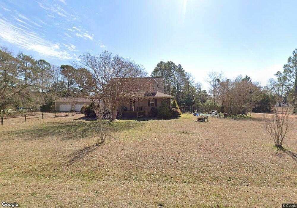
185 Tom Mann Rd Newport, NC 28570
Estimated Value: $334,000 - $462,000
3
Beds
3
Baths
1,810
Sq Ft
$207/Sq Ft
Est. Value
About This Home
This home is located at 185 Tom Mann Rd, Newport, NC 28570 and is currently estimated at $375,203, approximately $207 per square foot. 185 Tom Mann Rd is a home located in Carteret County with nearby schools including Newport Elementary School, Newport Middle School, and West Carteret High School.
Ownership History
Date
Name
Owned For
Owner Type
Purchase Details
Closed on
Jul 2, 2015
Sold by
Mailhoit Ronald J and Montgomery Linda Jean
Bought by
Mailhoit Ronald J
Current Estimated Value
Home Financials for this Owner
Home Financials are based on the most recent Mortgage that was taken out on this home.
Original Mortgage
$184,000
Interest Rate
3.89%
Mortgage Type
New Conventional
Create a Home Valuation Report for This Property
The Home Valuation Report is an in-depth analysis detailing your home's value as well as a comparison with similar homes in the area
Home Values in the Area
Average Home Value in this Area
Purchase History
| Date | Buyer | Sale Price | Title Company |
|---|---|---|---|
| Mailhoit Ronald J | -- | Wfg Lender Services |
Source: Public Records
Mortgage History
| Date | Status | Borrower | Loan Amount |
|---|---|---|---|
| Closed | Mailhoit Ronald J | $184,000 |
Source: Public Records
Tax History Compared to Growth
Tax History
| Year | Tax Paid | Tax Assessment Tax Assessment Total Assessment is a certain percentage of the fair market value that is determined by local assessors to be the total taxable value of land and additions on the property. | Land | Improvement |
|---|---|---|---|---|
| 2025 | $1,180 | $327,943 | $64,348 | $263,595 |
| 2024 | $1,133 | $215,585 | $47,250 | $168,335 |
| 2023 | $1,164 | $215,585 | $47,250 | $168,335 |
| 2022 | $1,142 | $215,585 | $47,250 | $168,335 |
| 2021 | $1,099 | $215,585 | $47,250 | $168,335 |
| 2020 | $1,107 | $215,585 | $47,250 | $168,335 |
| 2019 | $1,110 | $232,422 | $54,000 | $178,422 |
| 2017 | $1,063 | $232,422 | $54,000 | $178,422 |
| 2016 | $1,063 | $232,422 | $54,000 | $178,422 |
| 2015 | $1,040 | $232,422 | $54,000 | $178,422 |
| 2014 | $1,080 | $243,354 | $48,075 | $195,279 |
Source: Public Records
Map
Nearby Homes
- 764 Chatham St
- 757 Chatham St
- 554 Chatham St
- 223 Independence Blvd
- 251 Independence Blvd
- 258 Independence Blvd
- 262 Independence Blvd
- 102 Candace Ct
- 202 Courtyard W
- 730 Chatham St
- 2211 Park Ave
- 113 Duncan Ln
- 129 Bayberry Rd
- 8202 Highway 70
- Tyler Plan at Heritage Pointe - Carolina Series
- Bayhill Plan at Heritage Pointe - Carolina Series
- Ryan Plan at Heritage Pointe - Carolina Series
- Thornwood Plan at Heritage Pointe - Carolina Series
- Pamlico Plan at Heritage Pointe - Carolina Series
- Westin Plan at Heritage Pointe - Carolina Series
- 909 Chatham St
- 901 Chatham St
- 174 Sherwood Rd
- 182 Sherwood Rd
- 217 Tom Mann Rd
- 893 Chatham St
- 926 Chatham St
- 152 Sherwood Rd
- 891 Chatham St
- 218 Tom Mann Rd
- 152 Sherwood Dr
- 910 Chatham St
- 940 Chatham St
- 146 Sherwood Rd
- 146 Sherwood Dr
- 914 Chatham St
- 165 Sherwood Dr
- 885 Chatham St
- 185 Woodland Dr
- 138 Sherwood Dr