
Seller's Agent in 2025
Andrew Herrera II
Berkshire Hathaway-Franciscan
(415) 596-8777
6 in this area
115 Total Sales
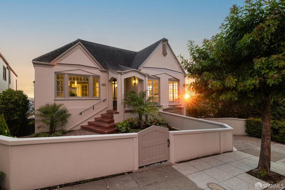


Magnificent English Tudor Pacific Ocean view home on huge, oversized lot & great block! Charming courtyard w/garden entrance leads to an open-arched portico w/notable original front door & into an impressive foyer w/coat closet. Spectacular formal living rm w/vaulted barrel ceiling & rich parquet hardwood floors boasts an imposing fireplace w/stately mantel, built-in bookshelves on either side, stylish wall sconces & large picture windows w/sweeping views from the Olympic Club to the Pacific Ocean. Splendid formal dining rm w/box moldings & striking chandelier, perfect for entertaining! Beautifully updated kitchen w/spacious six-sided breakfast rm showcases all stainless-steel appliances, incl a Jenn-Air gas range, sleek honed quartz counters, ample custom cabinetry, pantry & built-in spice rack. 3BR/2BA on the same level incl the fabulous master suite w/panoramic views of Harding Park, Lake Merced & the Pacific Ocean. Lower level incl a terrific BR en-suite & a sumptuous family rm w/wet-bar & walk-out deck w/amazing ocean views. Enormous 3 car garage w/laundry area, gym space & ample storage. Extraordinary, park-like landscaped backyard w/paver patio, walking paths, arbor, tradesman's entrance & lush mature plants & trees, incl magnolia, maple, pygmy date palms & bougainvillea!
Last Agent to Sell the Property
Berkshire Hathaway-Franciscan License #01199229 Listed on: 10/16/2025
| Date | Type | Sale Price | Title Company |
|---|---|---|---|
| Grant Deed | -- | Wfg National Title Insurance C | |
| Grant Deed | $526,000 | First American Title Co | |
| Interfamily Deed Transfer | -- | -- |
| Date | Status | Loan Amount | Loan Type |
|---|---|---|---|
| Open | $1,030,000 | New Conventional | |
| Previous Owner | $420,800 | No Value Available |
| Date | Event | Price | List to Sale | Price per Sq Ft |
|---|---|---|---|---|
| 11/06/2025 11/06/25 | Sold | $2,630,000 | +10.7% | $1,058 / Sq Ft |
| 10/23/2025 10/23/25 | Pending | -- | -- | -- |
| 10/16/2025 10/16/25 | For Sale | $2,375,000 | -- | $955 / Sq Ft |
| Year | Tax Paid | Tax Assessment Tax Assessment Total Assessment is a certain percentage of the fair market value that is determined by local assessors to be the total taxable value of land and additions on the property. | Land | Improvement |
|---|---|---|---|---|
| 2025 | $10,135 | $824,602 | $603,567 | $221,035 |
| 2024 | $10,135 | $808,434 | $591,733 | $216,701 |
| 2023 | $9,976 | $792,583 | $580,131 | $212,452 |
| 2022 | $9,777 | $777,043 | $568,756 | $208,287 |
| 2021 | $9,599 | $761,807 | $557,604 | $204,203 |
| 2020 | $9,654 | $753,997 | $551,887 | $202,110 |
| 2019 | $9,323 | $739,214 | $541,066 | $198,148 |
| 2018 | $9,008 | $724,720 | $530,457 | $194,263 |
| 2017 | $8,639 | $710,510 | $520,056 | $190,454 |
| 2016 | $8,484 | $696,579 | $509,859 | $186,720 |
| 2015 | $8,377 | $686,117 | $502,201 | $183,916 |
| 2014 | $8,155 | $672,678 | $492,364 | $180,314 |
Seller's Agent in 2025
Andrew Herrera II
Berkshire Hathaway-Franciscan
(415) 596-8777
6 in this area
115 Total Sales
Buyer's Agent in 2025
Melissa Radtke
Real Estate Experts ERA Powered
(650) 688-6125
1 in this area
33 Total Sales
Source: San Francisco Association of REALTORS®
MLS Number: 425079982
APN: 3276-023
Disclaimer: Certain information contained herein is derived from information provided by parties other than Homes.com. All information provided is deemed reliable, but is not guaranteed to be accurate and should be independently verified.
![]() IDX information is provided exclusively for personal, non-commercial use, and may not be used for any purpose other than to identify prospective properties consumers may be interested in purchasing.
IDX information is provided exclusively for personal, non-commercial use, and may not be used for any purpose other than to identify prospective properties consumers may be interested in purchasing.
Information is deemed reliable but not guaranteed.
Ask me questions while you tour the home.