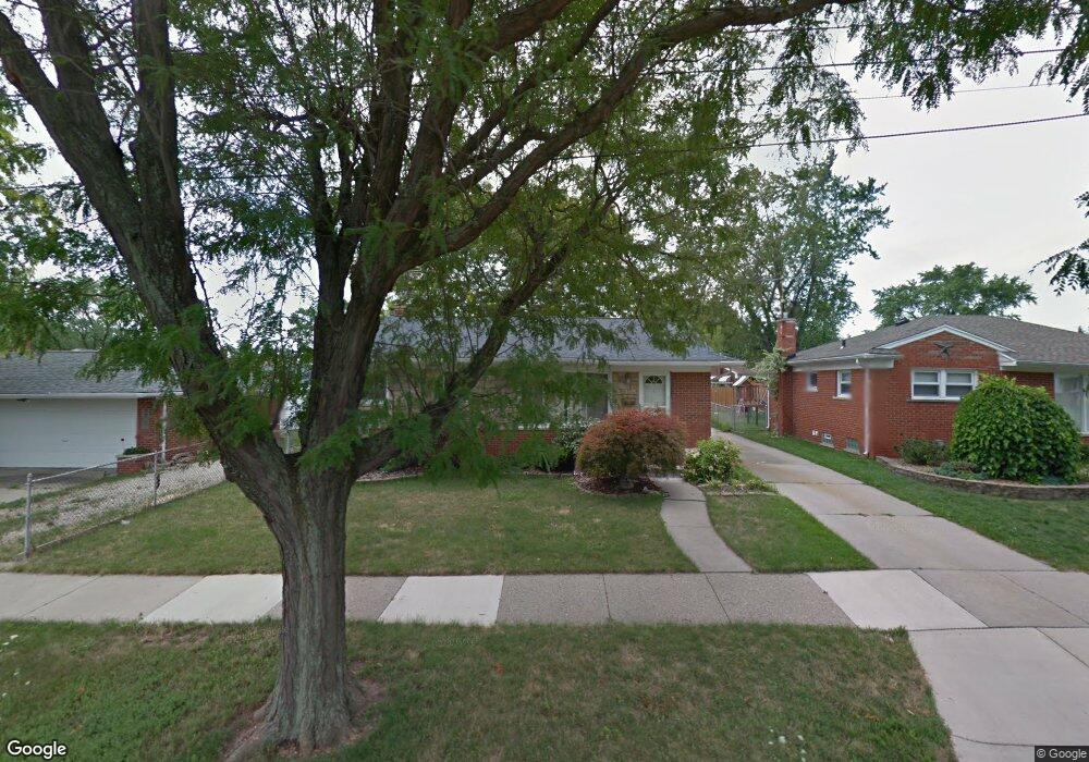
18504 Forest Ave Eastpointe, MI 48021
Estimated Value: $179,000 - $221,000
--
Bed
2
Baths
1,054
Sq Ft
$183/Sq Ft
Est. Value
About This Home
This home is located at 18504 Forest Ave, Eastpointe, MI 48021 and is currently estimated at $192,388, approximately $182 per square foot. 18504 Forest Ave is a home located in Macomb County with nearby schools including Forest Park Elementary School, Eastpointe Middle School, and Reach Charter Academy.
Ownership History
Date
Name
Owned For
Owner Type
Purchase Details
Closed on
Jul 20, 2006
Sold by
Bastianon Douglas J and Bastianon Monique
Bought by
Hubbard Lucretia R
Current Estimated Value
Create a Home Valuation Report for This Property
The Home Valuation Report is an in-depth analysis detailing your home's value as well as a comparison with similar homes in the area
Home Values in the Area
Average Home Value in this Area
Purchase History
| Date | Buyer | Sale Price | Title Company |
|---|---|---|---|
| Hubbard Lucretia R | $130,000 | Metropolitan Title Company |
Source: Public Records
Tax History Compared to Growth
Tax History
| Year | Tax Paid | Tax Assessment Tax Assessment Total Assessment is a certain percentage of the fair market value that is determined by local assessors to be the total taxable value of land and additions on the property. | Land | Improvement |
|---|---|---|---|---|
| 2025 | $3,652 | $88,000 | $0 | $0 |
| 2024 | $2,917 | $82,800 | $0 | $0 |
| 2023 | $2,650 | $74,800 | $0 | $0 |
| 2022 | $3,389 | $64,200 | $0 | $0 |
| 2021 | $3,470 | $57,800 | $0 | $0 |
| 2020 | $2,092 | $57,000 | $0 | $0 |
| 2019 | $2,805 | $46,000 | $0 | $0 |
| 2018 | $2,257 | $40,430 | $0 | $0 |
| 2017 | $1,988 | $35,620 | $3,460 | $32,160 |
| 2016 | $2,512 | $35,620 | $0 | $0 |
| 2015 | $1,877 | $31,010 | $0 | $0 |
| 2013 | $2,489 | $30,330 | $0 | $0 |
Source: Public Records
Map
Nearby Homes
- 24296 Roxana Ave
- 24301 Kelly Rd
- 24336 Warrington Ct
- 24821 Almond Ave
- 24504 Marine Ave
- 24880 Warrington Ave
- 23805 Raven Ave
- 24648 Wilmot Ave
- 24834 Raven Ave
- 24893 Raven Ave
- 23805 Johnston Ave
- 23329 Roxana Ave
- 23311 Courtland Ave
- 23785 Wilmot Ave
- 24675 Ridgecroft Ave
- 24883 Wilmot Ave
- 23785 Schroeder Ave
- 23080 Marine Ave
- 23373 Wilmot Ave
- 23038 Rosalind Ave
- 18494 Forest Ave
- 24347 Courtland Ave
- 24337 Courtland Ave
- 18484 Forest Ave
- 18505 Courtland Ct
- 24327 Courtland Ave
- 24317 Courtland Ave
- 24546 Almond Ave
- 18474 Forest Ave
- 18495 Courtland Ct
- 24565 Almond Ave
- 18525 Forest Ave
- 24566 Almond Ave
- 24346 Roxana Ave
- 18535 Forest Ave
- 24575 Almond Ave
- 24346 Courtland Ave
- 24576 Almond Ave
- 24566 Roxana Ave
- 24326 Courtland Ave