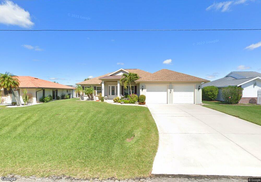
18512 Alphonse Cir Port Charlotte, FL 33948
Estimated Value: $469,000 - $641,000
--
Bed
3
Baths
2,312
Sq Ft
$225/Sq Ft
Est. Value
About This Home
This home is located at 18512 Alphonse Cir, Port Charlotte, FL 33948 and is currently estimated at $519,643, approximately $224 per square foot. 18512 Alphonse Cir is a home located in Charlotte County with nearby schools including Meadow Park Elementary School, Murdock Middle School, and Port Charlotte High School.
Ownership History
Date
Name
Owned For
Owner Type
Purchase Details
Closed on
Mar 25, 2011
Sold by
Straka Donald M and Straka Gerrie A
Bought by
Fiske Allen T and Fiske Elaine F
Current Estimated Value
Purchase Details
Closed on
Nov 3, 2008
Sold by
Straka Donald M and Straka Gerri A
Bought by
Straka Donald M and Straka Gerrie A
Purchase Details
Closed on
Feb 12, 2004
Sold by
Oconnor Ann and Confortin Edward
Bought by
Straka Donald M and Straka Gerrie A
Home Financials for this Owner
Home Financials are based on the most recent Mortgage that was taken out on this home.
Original Mortgage
$90,000
Interest Rate
5.63%
Create a Home Valuation Report for This Property
The Home Valuation Report is an in-depth analysis detailing your home's value as well as a comparison with similar homes in the area
Home Values in the Area
Average Home Value in this Area
Purchase History
| Date | Buyer | Sale Price | Title Company |
|---|---|---|---|
| Fiske Allen T | $54,900 | Suncoast One Title Inc | |
| Straka Donald M | -- | Attorney | |
| Straka Donald M | $150,000 | -- |
Source: Public Records
Mortgage History
| Date | Status | Borrower | Loan Amount |
|---|---|---|---|
| Previous Owner | Straka Donald M | $90,000 |
Source: Public Records
Tax History Compared to Growth
Tax History
| Year | Tax Paid | Tax Assessment Tax Assessment Total Assessment is a certain percentage of the fair market value that is determined by local assessors to be the total taxable value of land and additions on the property. | Land | Improvement |
|---|---|---|---|---|
| 2023 | $5,147 | $319,628 | $0 | $0 |
| 2022 | $4,987 | $310,318 | $0 | $0 |
| 2021 | $5,004 | $301,280 | $0 | $0 |
| 2020 | $4,934 | $297,120 | $0 | $0 |
| 2019 | $4,813 | $290,440 | $0 | $0 |
| 2018 | $4,469 | $285,025 | $0 | $0 |
| 2017 | $4,435 | $279,163 | $0 | $0 |
| 2016 | $4,422 | $273,421 | $0 | $0 |
| 2015 | $4,440 | $271,520 | $0 | $0 |
| 2014 | $4,405 | $269,365 | $0 | $0 |
Source: Public Records
Map
Nearby Homes
- 4225 Swensson St
- 18585 Klingler Cir
- 4240 Kilpatrick St
- 18593 Alphonse Cir
- 18576 Alphonse Cir
- 18641 Klingler Cir
- 4224 Kilpatrick St
- 4210 Day St
- 4250 Day St
- 4203 Day St
- 18537 Klingler Cir
- 18664 Klingler Cir
- 4099 Dotham St
- 4091 Dotham St
- 18538 Klingler Cir
- 18428 Ackerman Ave
- 4261 Day St
- 18854 Ackerman Ave
- 18444 Ackerman Ave
- 18149 Ackerman Ave
- 18520 Alphonse Cir
- 18528 Alphonse Cir
- 18495 Alphonse Cir
- 4208 Swensson St
- 18490 Alphonse Cir
- 18535 Alphonse Cir
- 18471 Alphonse Cir
- 4201 Swensson St
- 18478 Alphonse Cir
- 18544 Alphonse Cir
- 18593 Klingler Cir
- 18463 Alphonse Cir
- 4209 Swensson St
- 18470 Alphonse Cir
- 18601 Klingler Cir
- 4200 Swensson St
- 18552 Alphonse Cir
- 18551 Alphonse Cir
- 4217 Swensson St