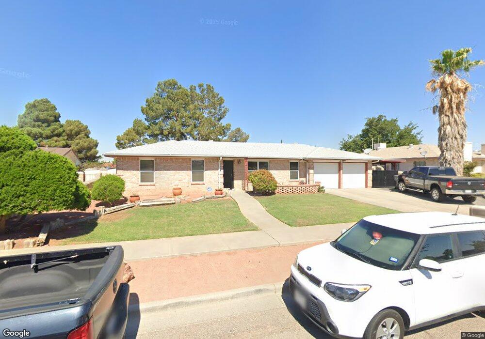
1853 Tommy Aaron Dr El Paso, TX 79936
Vista Del Sol NeighborhoodEstimated Value: $268,975 - $283,000
4
Beds
2
Baths
1,779
Sq Ft
$153/Sq Ft
Est. Value
About This Home
This home is located at 1853 Tommy Aaron Dr, El Paso, TX 79936 and is currently estimated at $272,744, approximately $153 per square foot. 1853 Tommy Aaron Dr is a home located in El Paso County with nearby schools including Tierra Del Sol Elementary School, J M Hanks High School, and EL PASO LEADERSHIP ACADEMY - MIDDLE EAST.
Ownership History
Date
Name
Owned For
Owner Type
Purchase Details
Closed on
Nov 18, 2024
Sold by
Bishop John Stephan
Bought by
Bishop John Stephan and Bishop Cecilia Lorena
Current Estimated Value
Purchase Details
Closed on
Nov 16, 2022
Sold by
Marquez Bishop Graciela
Bought by
Bishop John S
Purchase Details
Closed on
Sep 17, 2014
Sold by
Estrada Graciela M and Bishop Graciela M
Bought by
Bishop John S
Purchase Details
Closed on
Nov 3, 1994
Sold by
Estrada Jesus J
Bought by
Estrada Graciela M
Create a Home Valuation Report for This Property
The Home Valuation Report is an in-depth analysis detailing your home's value as well as a comparison with similar homes in the area
Home Values in the Area
Average Home Value in this Area
Purchase History
| Date | Buyer | Sale Price | Title Company |
|---|---|---|---|
| Bishop John Stephan | -- | None Listed On Document | |
| Bishop John Stephan | -- | None Listed On Document | |
| Bishop John S | -- | None Listed On Document | |
| Bishop John S | -- | None Available | |
| Estrada Graciela M | -- | -- |
Source: Public Records
Tax History Compared to Growth
Tax History
| Year | Tax Paid | Tax Assessment Tax Assessment Total Assessment is a certain percentage of the fair market value that is determined by local assessors to be the total taxable value of land and additions on the property. | Land | Improvement |
|---|---|---|---|---|
| 2025 | -- | $279,435 | -- | -- |
| 2024 | -- | $254,032 | -- | -- |
| 2023 | $6,721 | $230,938 | $0 | $0 |
| 2022 | $6,520 | $209,944 | $0 | $0 |
| 2021 | $6,204 | $190,858 | $31,559 | $159,299 |
| 2020 | $5,597 | $177,194 | $28,646 | $148,548 |
| 2018 | $5,339 | $171,681 | $28,646 | $143,035 |
| 2017 | $4,920 | $161,032 | $28,646 | $132,386 |
| 2016 | $4,473 | $146,322 | $28,646 | $117,676 |
| 2015 | $2,210 | $146,322 | $28,646 | $117,676 |
| 2014 | $2,210 | $147,714 | $28,646 | $119,068 |
Source: Public Records
Map
Nearby Homes
- 1868 Tom Bolt Dr
- 1913 Seagull Dr
- 1817 Hugh Royer Place
- 1901 Bobby Jones Dr
- 1804 Jerry Abbott St
- 2001 Bobby Jones Dr Unit A
- 1739 Jerry Abbott St
- 2009 Bobby Jones Dr Unit B
- 11016 Bob Stone Dr
- 11012 Bob Stone Dr
- 11013 Bob Stone Dr
- 11204 Bob Mitchell Dr
- 2604 Anise Dr
- 1703 Robert Wynn St
- 2101 E Glen Dr
- 1700 Jerry Abbott St
- 2308 Tom Watson Ct
- 1844 Jack Nicklaus Dr Unit 1846
- 1617 Tommy Aaron Dr
- 2348 Sea Side Dr
- 1849 Tommy Aaron Dr
- 1857 Tommy Aaron Dr
- 1848 Tom Bolt Dr
- 1852 Tom Bolt Dr
- 1861 Tommy Aaron Dr
- 1844 Tom Bolt Dr
- 1845 Tommy Aaron Dr
- 1856 Tom Bolt Dr
- 1840 Tom Bolt Dr
- 1865 Tommy Aaron Dr
- 1860 Tom Bolt Dr
- 1841 Tommy Aaron Dr
- 1851 Tom Bolt Dr
- 1836 Tom Bolt Dr
- 1847 Tom Bolt Dr
- 1855 Tom Bolt Dr
- 1843 Tom Bolt Dr
- 1864 Tom Bolt Dr
- 1859 Tom Bolt Dr
- 1832 Tom Bolt Dr