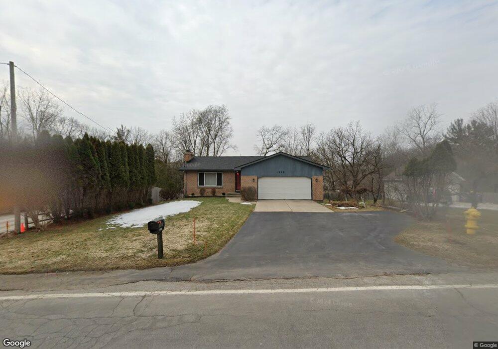
1855 Perkins Ave NE Grand Rapids, MI 49505
North East Citizens Action NeighborhoodEstimated Value: $294,682 - $365,000
2
Beds
2
Baths
1
Sq Ft
$328,421/Sq Ft
Est. Value
About This Home
This home is located at 1855 Perkins Ave NE, Grand Rapids, MI 49505 and is currently estimated at $328,421, approximately $328,421 per square foot. 1855 Perkins Ave NE is a home located in Kent County with nearby schools including Riverside Middle School, Union High School, and Lighthouse Academy - Waalkes Campus.
Ownership History
Date
Name
Owned For
Owner Type
Purchase Details
Closed on
Sep 12, 2022
Sold by
Doyle Renee C
Bought by
Doyle Renee C
Current Estimated Value
Purchase Details
Closed on
Nov 11, 1994
Sold by
Smith Smith R R and Smith Doyle P
Bought by
Doyle Phil Renee
Create a Home Valuation Report for This Property
The Home Valuation Report is an in-depth analysis detailing your home's value as well as a comparison with similar homes in the area
Home Values in the Area
Average Home Value in this Area
Purchase History
| Date | Buyer | Sale Price | Title Company |
|---|---|---|---|
| Doyle Renee C | -- | Land Title | |
| Doyle Phil Renee | $97,000 | -- |
Source: Public Records
Tax History Compared to Growth
Tax History
| Year | Tax Paid | Tax Assessment Tax Assessment Total Assessment is a certain percentage of the fair market value that is determined by local assessors to be the total taxable value of land and additions on the property. | Land | Improvement |
|---|---|---|---|---|
| 2025 | $2,328 | $127,400 | $0 | $0 |
| 2024 | $2,328 | $122,700 | $0 | $0 |
| 2023 | $2,362 | $115,600 | $0 | $0 |
| 2022 | $2,242 | $101,100 | $0 | $0 |
| 2021 | $2,192 | $96,500 | $0 | $0 |
| 2020 | $2,055 | $85,400 | $0 | $0 |
| 2019 | $2,152 | $80,000 | $0 | $0 |
| 2018 | $2,079 | $73,500 | $0 | $0 |
| 2017 | $2,024 | $64,400 | $0 | $0 |
| 2016 | $2,048 | $61,800 | $0 | $0 |
| 2015 | $1,905 | $61,800 | $0 | $0 |
| 2013 | -- | $56,600 | $0 | $0 |
Source: Public Records
Map
Nearby Homes
- 2016 Tall Meadow St NE
- 2037 Tall Meadow St NE Unit 13
- 2041 Krislin St
- 1600 Cherry Hill Dr NE
- 2058 Ken Ade St NE Unit 147
- 2324 Whimbrel Ct NE
- 2151 Chelsea Rd NE
- 1759 Briarcliff Dr NE
- 2112 Jo Dean Ct NE
- 1524 Sweet St NE
- 1739 Waldorn Ave NE
- 1455 Ball Ave NE
- 1336 Banbury Ave NE
- 1444 Sweet St NE
- 1410 Rothbury Dr NE
- 2353 Midvale St NE
- 1666 Carlton Ave NE
- 1261 Banbury Ave NE
- 1250 Walwood Dr NE
- 2098 Cranbrook Dr NE Unit 51
- 1845 Perkins Ave NE
- 1865 Perkins Ave NE
- 1846 Brookmoor Ct NE
- 1840 Brookmoor Ct NE
- 1810 Perkins Ave NE
- 1919 Brookmoor Dr NE
- 1885 Perkins Ave NE
- 1850 Brookmoor Ct NE
- 1874 Perkins Ave NE
- 1834 Brookmoor Ct NE
- 1949 Brookmoor Dr NE
- 1888 Perkins Ave NE
- 1909 Perkins Ave NE
- 1826 Brookmoor Ct NE
- 1847 Brookmoor Ct NE
- 1839 Brookmoor Ct NE
- 1812 Brookmoor Ct NE
- 1920 Perkins Ave NE
- 1925 Perkins Ave NE
- 1847 Forland Ct NE