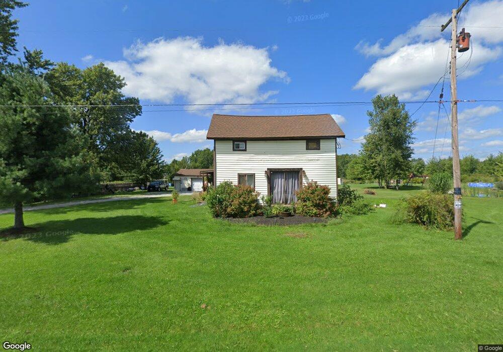
18578 State Route 511 Wellington, OH 44090
Estimated Value: $230,000 - $299,000
2
Beds
2
Baths
1,427
Sq Ft
$179/Sq Ft
Est. Value
About This Home
This home is located at 18578 State Route 511, Wellington, OH 44090 and is currently estimated at $255,749, approximately $179 per square foot. 18578 State Route 511 is a home located in Lorain County with nearby schools including Firelands Elementary School, Firelands Middle School, and Firelands High School.
Ownership History
Date
Name
Owned For
Owner Type
Purchase Details
Closed on
Mar 8, 2002
Sold by
Preston Jeff A and Preston Brenda L
Bought by
Pierce Matthew J
Current Estimated Value
Home Financials for this Owner
Home Financials are based on the most recent Mortgage that was taken out on this home.
Original Mortgage
$89,725
Interest Rate
6.87%
Purchase Details
Closed on
Apr 13, 1999
Sold by
Contimortgage Corp
Bought by
Preston Jeff A and Preston Brenda L
Home Financials for this Owner
Home Financials are based on the most recent Mortgage that was taken out on this home.
Original Mortgage
$60,000
Interest Rate
10.75%
Purchase Details
Closed on
Sep 11, 1998
Sold by
Pocock Kenneth W and Pocock Bonnie E
Bought by
Contimortgage Corp
Create a Home Valuation Report for This Property
The Home Valuation Report is an in-depth analysis detailing your home's value as well as a comparison with similar homes in the area
Home Values in the Area
Average Home Value in this Area
Purchase History
| Date | Buyer | Sale Price | Title Company |
|---|---|---|---|
| Pierce Matthew J | $92,500 | Resource Title Agency Inc | |
| Preston Jeff A | $75,000 | Lorain County Title Co Inc | |
| Contimortgage Corp | $60,000 | -- |
Source: Public Records
Mortgage History
| Date | Status | Borrower | Loan Amount |
|---|---|---|---|
| Previous Owner | Pierce Matthew J | $89,725 | |
| Previous Owner | Preston Jeff A | $60,000 |
Source: Public Records
Tax History Compared to Growth
Tax History
| Year | Tax Paid | Tax Assessment Tax Assessment Total Assessment is a certain percentage of the fair market value that is determined by local assessors to be the total taxable value of land and additions on the property. | Land | Improvement |
|---|---|---|---|---|
| 2024 | $2,976 | $66,301 | $19,793 | $46,508 |
| 2023 | $2,298 | $46,466 | $17,168 | $29,299 |
| 2022 | $2,220 | $46,466 | $17,168 | $29,299 |
| 2021 | $2,217 | $46,466 | $17,168 | $29,299 |
| 2020 | $1,955 | $39,320 | $14,530 | $24,790 |
| 2019 | $1,941 | $39,320 | $14,530 | $24,790 |
| 2018 | $1,894 | $39,320 | $14,530 | $24,790 |
| 2017 | $1,800 | $36,550 | $10,820 | $25,730 |
| 2016 | $1,824 | $36,550 | $10,820 | $25,730 |
| 2015 | $1,825 | $36,550 | $10,820 | $25,730 |
| 2014 | $1,535 | $30,150 | $10,820 | $19,330 |
| 2013 | $1,471 | $28,870 | $10,820 | $18,050 |
Source: Public Records
Map
Nearby Homes
- 18315 Gifford Rd
- 52025 Betts Rd
- 20011 Gore Orphanage Rd
- 20303 Mosher Rd
- 48685 Ohio 303
- 18233 Quarry Rd
- 15806 State Route 511
- 20765 Quarry Rd
- 22697 Gore Orphanage Rd
- 41 Court St
- 16873 Pitts Rd
- 16815 Pitts Rd
- 21251 Pitts Rd
- 0 Ohio 303
- 0 Peck Wadsworth Rd
- 0 Butler Rd N
- 5810 U S 20 Unit 47
- 5810 U S 20 Unit 17
- 5810 U S 20 Unit 72
- 5810 U S 20 Unit 98
- 18610 State Route 511
- 50893 Betts Rd
- 50961 Betts Rd
- 18471 State Route 511
- 51001 E Betts
- 51001 Betts Rd
- 18460 State Route 511
- 51005 Betts Rd
- 18430 State Route 511
- 51187 Betts Rd
- 18836 State Route 511
- 18836 Ohio 511
- 18336 State Route 511
- 51102 Betts Rd
- 51257 Betts Rd
- 51257 Betts Rd
- 18953 State Route 511
- 51279 Betts Rd
- 51264 Betts Rd
- 51315 Betts Rd