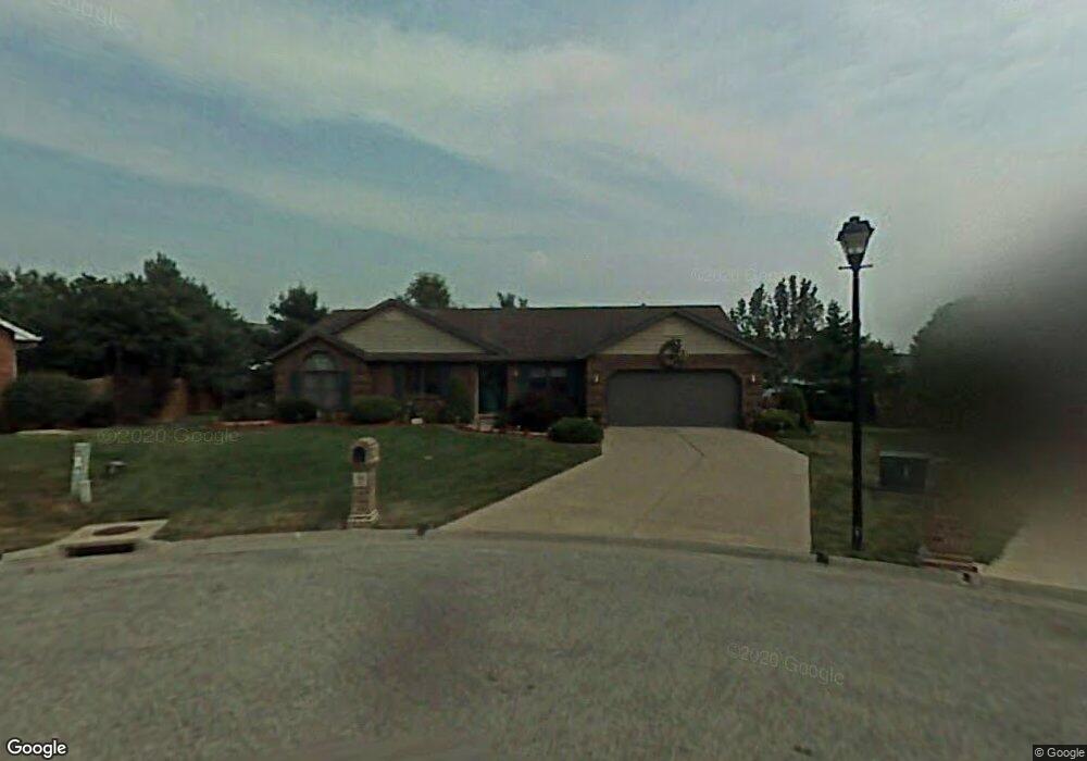
186 Calais Ct Belleville, IL 62226
Estimated Value: $277,000 - $301,000
--
Bed
--
Bath
2,020
Sq Ft
$144/Sq Ft
Est. Value
About This Home
This home is located at 186 Calais Ct, Belleville, IL 62226 and is currently estimated at $290,057, approximately $143 per square foot. 186 Calais Ct is a home located in St. Clair County with nearby schools including Wolf Branch Elementary School, Wolf Branch Middle School, and Elite Scholars STEAM Academy.
Ownership History
Date
Name
Owned For
Owner Type
Purchase Details
Closed on
Feb 20, 2014
Sold by
Lewis Ray and Lewis Bobbie
Bought by
Lewis Bobbie
Current Estimated Value
Purchase Details
Closed on
Jun 30, 2004
Sold by
Servos John J and Servos Teresa M
Bought by
Lewis Ray and Lewis Bobbie R
Home Financials for this Owner
Home Financials are based on the most recent Mortgage that was taken out on this home.
Original Mortgage
$140,720
Outstanding Balance
$71,082
Interest Rate
6.39%
Mortgage Type
Purchase Money Mortgage
Estimated Equity
$218,975
Purchase Details
Closed on
Jan 28, 2002
Sold by
Servos John J and Servos Teresa M
Bought by
Servos John J and Servos Teresa M
Home Financials for this Owner
Home Financials are based on the most recent Mortgage that was taken out on this home.
Original Mortgage
$122,000
Interest Rate
7.16%
Mortgage Type
Purchase Money Mortgage
Create a Home Valuation Report for This Property
The Home Valuation Report is an in-depth analysis detailing your home's value as well as a comparison with similar homes in the area
Home Values in the Area
Average Home Value in this Area
Purchase History
| Date | Buyer | Sale Price | Title Company |
|---|---|---|---|
| Lewis Bobbie | -- | None Available | |
| Lewis Ray | $176,000 | Chicago Title | |
| Servos John J | -- | Nations Title Agency Inc |
Source: Public Records
Mortgage History
| Date | Status | Borrower | Loan Amount |
|---|---|---|---|
| Open | Lewis Ray | $140,720 | |
| Previous Owner | Servos John J | $122,000 | |
| Closed | Lewis Ray | $26,385 |
Source: Public Records
Tax History Compared to Growth
Tax History
| Year | Tax Paid | Tax Assessment Tax Assessment Total Assessment is a certain percentage of the fair market value that is determined by local assessors to be the total taxable value of land and additions on the property. | Land | Improvement |
|---|---|---|---|---|
| 2024 | $3,474 | $74,853 | $12,959 | $61,894 |
| 2023 | $3,507 | $71,092 | $12,781 | $58,311 |
| 2022 | $4,489 | $64,747 | $11,640 | $53,107 |
| 2021 | $3,681 | $62,089 | $11,162 | $50,927 |
| 2020 | $3,732 | $57,823 | $10,395 | $47,428 |
| 2019 | $3,751 | $56,736 | $10,810 | $45,926 |
| 2018 | $3,846 | $55,287 | $10,534 | $44,753 |
| 2017 | $1,879 | $53,814 | $10,253 | $43,561 |
| 2016 | $3,697 | $51,959 | $9,900 | $42,059 |
| 2014 | $1,902 | $58,950 | $15,451 | $43,499 |
| 2013 | $3,941 | $58,950 | $15,451 | $43,499 |
Source: Public Records
Map
Nearby Homes
- 109 Bourdelais Dr
- 3944 Appaloosa Dr
- 3920 Michael John Dr
- 505 Thistle Ln
- 3857 Appaloosa Dr
- 525 Big Bend Blvd
- 1709 Old Park Ln
- 1705 Old Park Ln
- 1737 Old Park Ln
- 4906 Lawrence Dr
- 1745 Old Park Ln
- 3928 Red Bird Ln
- 3924 Red Bird Ln
- 1749 Old Park Ln
- 1753 Old Park Ln
- 3920 Red Bird Ln
- 1757 Old Park Ln
- 3916 Red Bird Ln
- 1878 Old Park Ln
- 3912 Red Bird Ln
- 190 Calais Ct
- 183 Calais Ct
- 153 Saint Sabre Dr
- 181 St Sabre
- 181 Saint Sabre Dr
- 151 Saint Sabre Dr
- 165 Saint Sabre Dr
- 179 Saint Sabre Dr
- 185 Saint Sabre Dr
- 194 Calais Ct
- 147 Saint Sabre Dr
- 187 Calais Ct
- 191 Saint Sabre Dr
- 191 Calais Ct
- 141 Saint Sabre Dr
- 198 Calais Ct
- 195 Saint Sabre Dr
- 195 Calais Ct
- 154 Saint Sabre Dr
- 182 Saint Sabre Dr