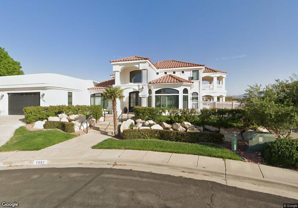
1861 E 970 South Cir Saint George, UT 84790
Estimated Value: $806,000 - $850,559
4
Beds
3
Baths
2,865
Sq Ft
$290/Sq Ft
Est. Value
About This Home
This home is located at 1861 E 970 South Cir, Saint George, UT 84790 and is currently estimated at $830,890, approximately $290 per square foot. 1861 E 970 South Cir is a home located in Washington County with nearby schools including Heritage School, Dixie Middle School, and Dixie Intermediate School.
Ownership History
Date
Name
Owned For
Owner Type
Purchase Details
Closed on
Jun 25, 2021
Sold by
Blake Bradley W
Bought by
Blake Bradley W and Blake Samantha L
Current Estimated Value
Purchase Details
Closed on
Dec 20, 2019
Sold by
Something Of Worth Inc
Bought by
Gardner Brent Ellsworth and Gardner Kristine Turley
Purchase Details
Closed on
Aug 7, 2013
Sold by
Khune Larry N and Khune Julia E
Bought by
Bosen Douglas R and Bosen Teresa
Home Financials for this Owner
Home Financials are based on the most recent Mortgage that was taken out on this home.
Original Mortgage
$230,000
Interest Rate
4.51%
Mortgage Type
Purchase Money Mortgage
Create a Home Valuation Report for This Property
The Home Valuation Report is an in-depth analysis detailing your home's value as well as a comparison with similar homes in the area
Home Values in the Area
Average Home Value in this Area
Purchase History
| Date | Buyer | Sale Price | Title Company |
|---|---|---|---|
| Blake Bradley W | -- | None Available | |
| Gardner Brent Ellsworth | -- | Southern Utah Title Co | |
| Bosen Douglas R | -- | Southern Utah Title |
Source: Public Records
Mortgage History
| Date | Status | Borrower | Loan Amount |
|---|---|---|---|
| Previous Owner | Bosen Douglas R | $230,000 |
Source: Public Records
Tax History Compared to Growth
Tax History
| Year | Tax Paid | Tax Assessment Tax Assessment Total Assessment is a certain percentage of the fair market value that is determined by local assessors to be the total taxable value of land and additions on the property. | Land | Improvement |
|---|---|---|---|---|
| 2025 | $3,101 | $465,080 | $110,000 | $355,080 |
| 2023 | $2,981 | $445,390 | $115,500 | $329,890 |
| 2022 | $3,155 | $443,300 | $112,750 | $330,550 |
| 2021 | $2,764 | $579,100 | $115,000 | $464,100 |
| 2020 | $2,527 | $498,800 | $115,000 | $383,800 |
| 2019 | $2,576 | $496,700 | $115,000 | $381,700 |
| 2018 | $2,538 | $245,245 | $0 | $0 |
| 2017 | $2,375 | $229,515 | $0 | $0 |
| 2016 | $2,371 | $211,915 | $0 | $0 |
| 2015 | $2,336 | $200,310 | $0 | $0 |
| 2014 | $2,133 | $184,030 | $0 | $0 |
Source: Public Records
Map
Nearby Homes
- 929 S Golda Dr
- 1031 S 1740 E
- 1031 S 1740 E Unit 3
- 994 S 1740 E
- 1051 S High Mesa Cir
- 71 Rocky Point Way Unit 71
- 1924 E 1220 S
- 0 Paisley Way Unit 24-253758
- 0 Tagans Way Unit 24-253776
- 0 Tagans Way Unit 24-253774
- 0 Tagans Way Unit 24-253755
- 0 Tagans Way Unit 24-253754
- 1804 E 580 Cir S
- 805 S River Rd Unit 21
- 805 S River Rd Unit 51
- 805 S River Rd Unit 31
- 1305 E Riverside Dr Unit 1
- 1664 E Boulder Springs Cir
- 1556 E Boulder Springs Cir
- 1501 Boulder Mountain Rd
- 1861 E 970 Cir S
- 925 S 5 Sisters Dr
- 925 S Five Sisters Dr
- 1873 E 970 S
- 1873 E 970 South Cir
- 1835 E 970 S
- 1854 E 970 S
- 1854 E 970 South Cir
- 0 Foremaster Ridge Unit 17-182140
- 0 Foremaster Ridge Unit 16-179620
- 0 Foremaster Ridge Unit 16-178393
- 0 Foremaster Ridge Unit 16-172630
- 0 Foremaster Ridge Unit 7-84193
- 0 Foremaster Ridge Unit 16-179606
- 0 Foremaster Ridge Unit 16-179621
- 0 Foremaster Ridge Unit 18-191249
- 0 Foremaster Ridge Unit 17-190107
- 0 Foremaster Ridge Unit 17-182141
- 0 Foremaster Ridge Unit 16-179618
- 0 Foremaster Ridge Unit 16-173128