
Seller's Agent in 2018
Alicia Chovan
Shorewest Realtors, Inc.
(262) 945-3166
2 in this area
74 Total Sales
Estimated Value: $528,000 - $676,000
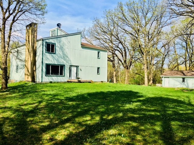
Live LARGE in this fantastic 4 bedroom 4 bath home on 4.45 acres in Bristol. The home has been well maintained-it has newer windows, exterior siding, roof /flashing and gutters - and the interior is freshly painted (with knock down texture) and clean carpet. Lower level is finished as well and has a walk-out door to patio. Enjoy the best of county and lake area living on the huge back deck or a quick walk down the street to Lake George. See all sorts of birds and wildlife, enjoy the sounds of the creek and summer night bonfires all in your own back yard. One year HSA warranty included.
Last Agent to Sell the Property
Shorewest Realtors, Inc. Brokerage Email: PropertyInfo@shorewest.com License #53563-90 Listed on: 04/20/2018
| Date | Buyer | Sale Price | Title Company |
|---|---|---|---|
| Wichman Edmund F | $345,000 | None Available |
| Date | Status | Borrower | Loan Amount |
|---|---|---|---|
| Open | Wichman Edmund F | $327,750 |
| Date | Event | Price | List to Sale | Price per Sq Ft |
|---|---|---|---|---|
| 10/06/2023 10/06/23 | Off Market | $345,000 | -- | -- |
| 09/20/2023 09/20/23 | For Sale | $139,900 | -59.4% | $37 / Sq Ft |
| 07/06/2018 07/06/18 | Sold | $345,000 | -- | $92 / Sq Ft |
| Year | Tax Paid | Tax Assessment Tax Assessment Total Assessment is a certain percentage of the fair market value that is determined by local assessors to be the total taxable value of land and additions on the property. | Land | Improvement |
|---|---|---|---|---|
| 2024 | $6,264 | $318,300 | $102,700 | $215,600 |
| 2023 | $5,375 | $318,300 | $102,700 | $215,600 |
| 2022 | $5,394 | $318,300 | $102,700 | $215,600 |
| 2021 | $5,252 | $318,300 | $102,700 | $215,600 |
| 2020 | $5,379 | $318,300 | $102,700 | $215,600 |
| 2019 | $5,120 | $320,900 | $105,300 | $215,600 |
| 2018 | $5,909 | $303,900 | $81,000 | $222,900 |
| 2017 | $6,206 | $303,900 | $81,000 | $222,900 |
| 2016 | $6,091 | $303,900 | $81,000 | $222,900 |
| 2015 | $5,674 | $303,900 | $81,000 | $222,900 |
| 2014 | -- | $303,900 | $81,000 | $222,900 |
Seller's Agent in 2018
Alicia Chovan
Shorewest Realtors, Inc.
(262) 945-3166
2 in this area
74 Total Sales
Buyer's Agent in 2018
Felicia Pavlica
RE/MAX
(262) 909-5008
1 in this area
35 Total Sales
Source: Metro MLS
MLS Number: 1576985
APN: 37-4-121-204-0140
Disclaimer: Certain information contained herein is derived from information provided by parties other than Homes.com. All information provided is deemed reliable, but is not guaranteed to be accurate and should be independently verified.
![]() IDX information is provided exclusively for personal, non-commercial use, and may not be used for any purpose other than to identify prospective properties consumers may be interested in purchasing.
IDX information is provided exclusively for personal, non-commercial use, and may not be used for any purpose other than to identify prospective properties consumers may be interested in purchasing.
IDX listing data provided by Multiple Listing Service, Inc. Information is supplied by seller and other third parties and has not been verified.
Copyright 2025 – Multiple Listing Service, Inc. – All Rights Reserved.