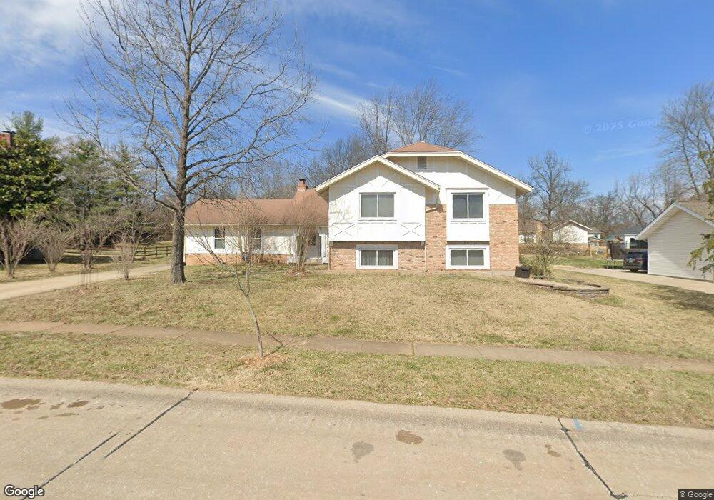
1863 Buckington Dr Chesterfield, MO 63017
Estimated Value: $552,000 - $668,000
4
Beds
3
Baths
3,038
Sq Ft
$201/Sq Ft
Est. Value
About This Home
This home is located at 1863 Buckington Dr, Chesterfield, MO 63017 and is currently estimated at $611,746, approximately $201 per square foot. 1863 Buckington Dr is a home located in St. Louis County with nearby schools including Henry Elementary School, Parkway West Middle School, and Parkway West High School.
Ownership History
Date
Name
Owned For
Owner Type
Purchase Details
Closed on
Sep 29, 2015
Sold by
Gray John C and Gray Xiao Bin
Bought by
Gray John C
Current Estimated Value
Purchase Details
Closed on
Jun 29, 2001
Sold by
Wade Linda L
Bought by
Gray John L and Gray Xiao Bin
Home Financials for this Owner
Home Financials are based on the most recent Mortgage that was taken out on this home.
Original Mortgage
$150,000
Outstanding Balance
$56,549
Interest Rate
7.16%
Estimated Equity
$555,197
Create a Home Valuation Report for This Property
The Home Valuation Report is an in-depth analysis detailing your home's value as well as a comparison with similar homes in the area
Home Values in the Area
Average Home Value in this Area
Purchase History
| Date | Buyer | Sale Price | Title Company |
|---|---|---|---|
| Gray John C | -- | None Available | |
| Gray John L | $188,000 | -- |
Source: Public Records
Mortgage History
| Date | Status | Borrower | Loan Amount |
|---|---|---|---|
| Open | Gray John L | $150,000 |
Source: Public Records
Tax History Compared to Growth
Tax History
| Year | Tax Paid | Tax Assessment Tax Assessment Total Assessment is a certain percentage of the fair market value that is determined by local assessors to be the total taxable value of land and additions on the property. | Land | Improvement |
|---|---|---|---|---|
| 2025 | $4,976 | $118,560 | $40,070 | $78,490 |
| 2024 | $4,976 | $75,200 | $28,060 | $47,140 |
| 2023 | $4,976 | $75,200 | $28,060 | $47,140 |
| 2022 | $4,998 | $71,690 | $24,040 | $47,650 |
| 2021 | $4,978 | $71,690 | $24,040 | $47,650 |
| 2020 | $4,672 | $64,600 | $23,390 | $41,210 |
| 2019 | $4,570 | $64,600 | $23,390 | $41,210 |
| 2018 | $5,220 | $68,480 | $23,390 | $45,090 |
| 2017 | $5,077 | $68,480 | $23,390 | $45,090 |
| 2016 | $4,814 | $61,690 | $18,050 | $43,640 |
| 2015 | $5,047 | $61,690 | $18,050 | $43,640 |
| 2014 | $4,133 | $53,960 | $11,780 | $42,180 |
Source: Public Records
Map
Nearby Homes
- 1870 Buckington Dr
- 1685 Ansonborough Dr
- 1620 Chalmers Dr
- 2317 Hank's Close Unit 186 STB
- 605 Aspen Ridge Ct
- 2168 Bantry Ct
- 14628 Big Timber Ln
- 731 Kraffel Ln
- 14443 Bantry Ln Unit 1
- 14260 Cedar Springs Dr
- 2021 Brook Hill Ct
- 2237 Ole Castle Ct
- 1505 Timberbluff Ct
- 2 Willow at Woods Mill Crossing
- 1519 Mallard Landing Ct
- 14422 Rue de Gascony Ct
- 719 Clayton Corners Dr
- 14300 Conway Meadows Ct E Unit 302
- 14300 Conway Meadows Ct E Unit 101
- 14316 E Conway Meadows Ct Unit 202
- 1869 Buckington Dr
- 1857 Buckington Dr
- 14482 Brittania Dr
- 14476 Brittania Dr
- 14488 Brittania Dr
- 1862 Buckington Dr
- 1875 Buckington Dr
- 1845 Buckington Dr
- 14470 Brittania Dr
- 1846 Oxborough Ct
- 1855 Braumton Ct
- 1852 Oxborough Ct
- 14494 Brittania Dr
- 1883 Buckington Dr
- 1882 Buckington Dr
- 1833 Buckington Dr
- 14479 Brittania Dr
- 14485 Brittania Dr
- 1858 Oxborough Ct
- 1869 Braumton Ct