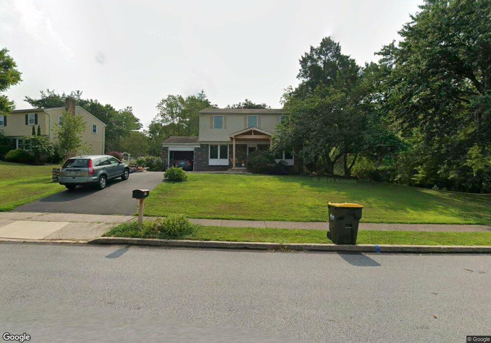
1864 Rampart Ln Lansdale, PA 19446
Estimated Value: $513,158 - $529,000
4
Beds
2
Baths
1,666
Sq Ft
$313/Sq Ft
Est. Value
About This Home
This home is located at 1864 Rampart Ln, Lansdale, PA 19446 and is currently estimated at $521,040, approximately $312 per square foot. 1864 Rampart Ln is a home located in Montgomery County with nearby schools including General Nash El School, Pennfield Middle School, and North Penn Senior High School.
Ownership History
Date
Name
Owned For
Owner Type
Purchase Details
Closed on
Mar 27, 1998
Sold by
Bank Of America Illinois
Bought by
Burns Thomas F and Burns Kathleen C
Current Estimated Value
Purchase Details
Closed on
Jul 24, 1997
Sold by
Lalley Francis P
Bought by
Bank Of America Illinois Tr
Purchase Details
Closed on
Jan 20, 1994
Sold by
Dibee Jack M and Dibee Elaine H
Bought by
Turner Robert J and Turner Margaret J
Create a Home Valuation Report for This Property
The Home Valuation Report is an in-depth analysis detailing your home's value as well as a comparison with similar homes in the area
Home Values in the Area
Average Home Value in this Area
Purchase History
| Date | Buyer | Sale Price | Title Company |
|---|---|---|---|
| Burns Thomas F | $143,000 | -- | |
| Bank Of America Illinois Tr | $1,899 | -- | |
| Turner Robert J | $164,900 | -- |
Source: Public Records
Tax History Compared to Growth
Tax History
| Year | Tax Paid | Tax Assessment Tax Assessment Total Assessment is a certain percentage of the fair market value that is determined by local assessors to be the total taxable value of land and additions on the property. | Land | Improvement |
|---|---|---|---|---|
| 2025 | $5,773 | $142,520 | $55,130 | $87,390 |
| 2024 | $5,773 | $142,520 | $55,130 | $87,390 |
| 2023 | $5,529 | $142,520 | $55,130 | $87,390 |
| 2022 | $5,189 | $142,520 | $55,130 | $87,390 |
| 2021 | $5,039 | $142,520 | $55,130 | $87,390 |
| 2020 | $4,810 | $142,520 | $55,130 | $87,390 |
| 2019 | $4,727 | $142,520 | $55,130 | $87,390 |
| 2018 | $920 | $142,520 | $55,130 | $87,390 |
| 2017 | $4,539 | $142,520 | $55,130 | $87,390 |
| 2016 | $4,483 | $142,520 | $55,130 | $87,390 |
| 2015 | $4,296 | $142,520 | $55,130 | $87,390 |
| 2014 | $4,296 | $142,520 | $55,130 | $87,390 |
Source: Public Records
Map
Nearby Homes
- 1825 Flintlock Cir
- 557 Broxton Ct
- 592 Blackmoor Ct
- 1653 Bridle Path Dr
- 128 Wellington Terrace
- 1116 Dogwood Ct
- 30 Greenbriar Ct
- 210 Berwick Place Unit 20E
- 205 Green Bank Way
- 19 Wildbriar Ct
- 912B Stockton Ct
- 1217A Crosshill Ct
- 3053 Sunny Ayre Dr
- 506 Clarella Ct
- 10 Bentwood Ct W
- 803 Poplar Ct
- 25 Chestnut Ct E
- 1017 Winfield Ct
- 1625 Clearbrook Rd
- 11 Elder Ct
- 1866 Rampart Ln
- 1847 Rampart Ln
- 1868 Rampart Ln
- 1845 Rampart Ln
- 1880 Rampart Ln
- 1878 Rampart Ln
- 1849 Rampart Ln
- 1870 Rampart Ln
- 1851 Rampart Ln
- 1876 Rampart Ln
- 1843 Rampart Ln
- 1853 Rampart Ln
- 1873 Rampart Ln
- 1872 Rampart Ln
- 1855 Rampart Ln
- 1874 Rampart Ln
- 1841 Rampart Ln
- 1871 Rampart Ln
- 2129 Pheasant Hill Rd
- 1801 Beth Ln