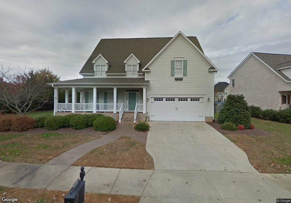
1867 Buxton Way Burlington, NC 27215
Southwest Burlington NeighborhoodEstimated Value: $517,000 - $588,000
4
Beds
3
Baths
2,760
Sq Ft
$198/Sq Ft
Est. Value
About This Home
This home is located at 1867 Buxton Way, Burlington, NC 27215 and is currently estimated at $546,246, approximately $197 per square foot. 1867 Buxton Way is a home located in Alamance County with nearby schools including Highland Elementary School, Turrentine Middle School, and Walter M. Williams High School.
Ownership History
Date
Name
Owned For
Owner Type
Purchase Details
Closed on
Oct 20, 2006
Sold by
Don Smith General Contrac
Bought by
Bogues Terrance D
Current Estimated Value
Home Financials for this Owner
Home Financials are based on the most recent Mortgage that was taken out on this home.
Original Mortgage
$332,025
Outstanding Balance
$196,478
Interest Rate
6.31%
Mortgage Type
New Conventional
Estimated Equity
$349,768
Create a Home Valuation Report for This Property
The Home Valuation Report is an in-depth analysis detailing your home's value as well as a comparison with similar homes in the area
Home Values in the Area
Average Home Value in this Area
Purchase History
| Date | Buyer | Sale Price | Title Company |
|---|---|---|---|
| Bogues Terrance D | $350,000 | -- |
Source: Public Records
Mortgage History
| Date | Status | Borrower | Loan Amount |
|---|---|---|---|
| Open | Bogues Terrance D | $332,025 |
Source: Public Records
Tax History Compared to Growth
Tax History
| Year | Tax Paid | Tax Assessment Tax Assessment Total Assessment is a certain percentage of the fair market value that is determined by local assessors to be the total taxable value of land and additions on the property. | Land | Improvement |
|---|---|---|---|---|
| 2025 | $2,640 | $534,389 | $60,000 | $474,389 |
| 2024 | $2,506 | $534,389 | $60,000 | $474,389 |
| 2023 | $4,868 | $534,389 | $60,000 | $474,389 |
| 2022 | $3,866 | $311,477 | $40,000 | $271,477 |
| 2021 | $3,897 | $311,477 | $40,000 | $271,477 |
| 2020 | $3,928 | $311,477 | $40,000 | $271,477 |
| 2019 | $3,938 | $311,477 | $40,000 | $271,477 |
| 2018 | $1,851 | $311,477 | $40,000 | $271,477 |
| 2017 | $3,667 | $311,477 | $40,000 | $271,477 |
| 2016 | $4,469 | $385,217 | $65,000 | $320,217 |
| 2015 | $2,223 | $385,217 | $65,000 | $320,217 |
| 2014 | $2,031 | $385,217 | $65,000 | $320,217 |
Source: Public Records
Map
Nearby Homes
- 4032 Comrie Ln
- 1947 Huntley Way
- 3935 Kincade Dr
- 2346 Campbell Loop Unit 32
- 2320 Campbell Loop
- 2207 Campbell Loop
- The Somerset 3 Plan at Mackintosh on the Lake - Birkdale
- 1936 Sinclair Trace
- 3248 Castlerock Dr
- 1966 Glenkirk Dr
- 1056 Kelso Ln
- 4005 Kinsley Trace
- 1064 Kelso Ln Unit 10
- 1096 Kelso Ln Unit 18
- 4110 Argyle Trail
- 1144 Kenross Dr
- 1159 Kenross Dr
- 4091 Hansel Trace
- 1254 Salters St
- 1861 Buxton Way
- 3986 Kincade Dr
- 1857 Buxton Way
- 3978 Kincade Dr
- 1864 Buxton Way
- 1870 Buxton Way
- 1860 Buxton Way Unit 3
- 1860 Buxton Way
- 1819 Huntley Way
- 1811 Huntley Way
- 1825 Huntley Way
- 1853 Buxton Way
- 1831 Huntley Way
- 1856 Buxton Way
- 3970 Kincade Dr
- 1906 Huntley Way
- 1910 Huntley Way
- 1845 Huntley Way
- 1918 Huntley Way
- 1852 Buxton Way