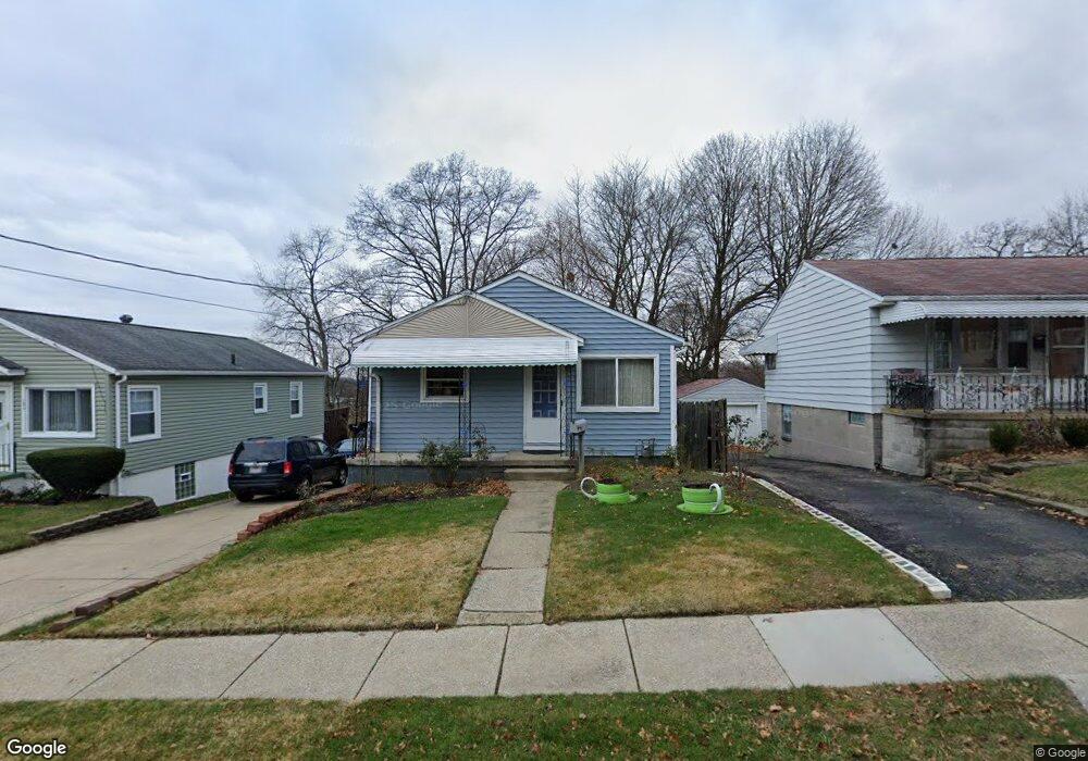
1868 9th St SW Akron, OH 44314
Kenmore NeighborhoodEstimated Value: $101,000 - $124,000
3
Beds
1
Bath
912
Sq Ft
$120/Sq Ft
Est. Value
About This Home
This home is located at 1868 9th St SW, Akron, OH 44314 and is currently estimated at $109,799, approximately $120 per square foot. 1868 9th St SW is a home located in Summit County with nearby schools including Pfeiffer Elementary School, Kenmore Garfield Community Learning Center, and Emmanuel Christian Academy.
Ownership History
Date
Name
Owned For
Owner Type
Purchase Details
Closed on
Oct 7, 2025
Sold by
Copen Ronald G and Copen Karysa J
Bought by
Copen Family Trust and Copen
Current Estimated Value
Purchase Details
Closed on
Jun 17, 2002
Sold by
Hitt Judy K and Hitt Judy K
Bought by
Copen Ronald G and Copen Karysa J
Home Financials for this Owner
Home Financials are based on the most recent Mortgage that was taken out on this home.
Original Mortgage
$73,950
Interest Rate
6.87%
Mortgage Type
VA
Create a Home Valuation Report for This Property
The Home Valuation Report is an in-depth analysis detailing your home's value as well as a comparison with similar homes in the area
Home Values in the Area
Average Home Value in this Area
Purchase History
| Date | Buyer | Sale Price | Title Company |
|---|---|---|---|
| Copen Family Trust | -- | None Listed On Document | |
| Copen Ronald G | $72,500 | Exchange Place Title Agency |
Source: Public Records
Mortgage History
| Date | Status | Borrower | Loan Amount |
|---|---|---|---|
| Previous Owner | Copen Ronald G | $73,950 |
Source: Public Records
Tax History
| Year | Tax Paid | Tax Assessment Tax Assessment Total Assessment is a certain percentage of the fair market value that is determined by local assessors to be the total taxable value of land and additions on the property. | Land | Improvement |
|---|---|---|---|---|
| 2025 | $1,504 | $27,682 | $6,612 | $21,070 |
| 2024 | $1,504 | $27,682 | $6,612 | $21,070 |
| 2023 | $1,504 | $27,682 | $6,612 | $21,070 |
| 2022 | $1,320 | $18,928 | $4,347 | $14,581 |
| 2021 | $1,321 | $18,928 | $4,347 | $14,581 |
| 2020 | $1,302 | $18,930 | $4,350 | $14,580 |
| 2019 | $1,432 | $19,040 | $4,120 | $14,920 |
| 2018 | $1,413 | $19,040 | $4,120 | $14,920 |
| 2017 | $1,647 | $19,040 | $4,120 | $14,920 |
| 2016 | $1,648 | $22,040 | $4,780 | $17,260 |
| 2015 | $1,647 | $22,040 | $4,780 | $17,260 |
| 2014 | $1,634 | $22,040 | $4,780 | $17,260 |
| 2013 | $1,598 | $21,990 | $4,780 | $17,210 |
Source: Public Records
Map
Nearby Homes
- 1865 9th St SW
- 788 Saxon Ave
- 780 Silvercrest Ave
- 1797 13th St SW Unit 1799
- 603 Indian Trail
- 896 Indian Trail
- 1655 Manchester Rd
- 1556 Overlook Dr
- 764 Harrison Ave
- 1725 Manchester Rd
- 546 Thelma Ave
- 545 Thelma Ave
- 543 Thelma Ave
- 539 Thelma Ave
- 534 Thelma Ave
- 1899 16th St SW
- 530 Thelma Ave
- 710 Clearview Ave
- 721 Polk Ave
- 2041 13th St SW
- 1872 9th St SW
- 1864 9th St SW
- 1856 9th St SW
- 1869 10th St SW
- 1882 9th St SW
- 1875 10th St SW
- 1854 9th St SW
- 1861 10th St SW
- 1861 9th St SW
- 1871 9th St SW
- 767 Witner Ave
- 1875 9th St SW
- 1853 10th St SW
- 1855 9th St SW
- 1850 9th St SW
- 1881 9th St SW
- 1849 10th St SW
- 756 Witner Ave
- 1845 9th St SW
- 1860 10th St SW
Your Personal Tour Guide
Ask me questions while you tour the home.