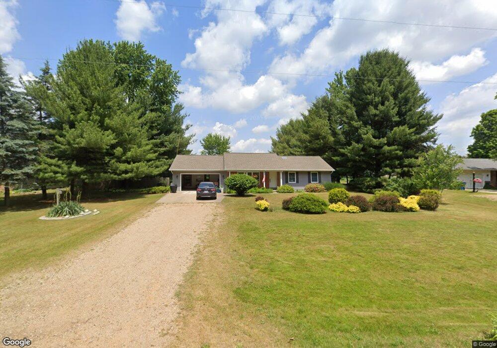
1869 104th Ave Otsego, MI 49078
Estimated Value: $267,267 - $321,000
3
Beds
3
Baths
1,556
Sq Ft
$188/Sq Ft
Est. Value
About This Home
This home is located at 1869 104th Ave, Otsego, MI 49078 and is currently estimated at $292,317, approximately $187 per square foot. 1869 104th Ave is a home located in Allegan County with nearby schools including Otsego High School, St. Margaret School, and Otsego Christian Academy.
Ownership History
Date
Name
Owned For
Owner Type
Purchase Details
Closed on
Dec 15, 2008
Sold by
Chase Bank Usa Na
Bought by
Us Bank National Association
Current Estimated Value
Home Financials for this Owner
Home Financials are based on the most recent Mortgage that was taken out on this home.
Original Mortgage
$118,320
Outstanding Balance
$78,826
Interest Rate
6.3%
Mortgage Type
Purchase Money Mortgage
Estimated Equity
$213,491
Purchase Details
Closed on
Apr 3, 2008
Sold by
Krill Donald P
Bought by
Chase Bank Usa Na
Purchase Details
Closed on
Jul 1, 1997
Sold by
Rogers Dale
Bought by
Krill Donald and Krill Maxine
Create a Home Valuation Report for This Property
The Home Valuation Report is an in-depth analysis detailing your home's value as well as a comparison with similar homes in the area
Home Values in the Area
Average Home Value in this Area
Purchase History
| Date | Buyer | Sale Price | Title Company |
|---|---|---|---|
| Us Bank National Association | -- | First American Title Ins Co | |
| Chase Bank Usa Na | $114,613 | None Available | |
| Krill Donald | $76,000 | -- |
Source: Public Records
Mortgage History
| Date | Status | Borrower | Loan Amount |
|---|---|---|---|
| Open | Us Bank National Association | $118,320 |
Source: Public Records
Tax History Compared to Growth
Tax History
| Year | Tax Paid | Tax Assessment Tax Assessment Total Assessment is a certain percentage of the fair market value that is determined by local assessors to be the total taxable value of land and additions on the property. | Land | Improvement |
|---|---|---|---|---|
| 2025 | $2,429 | $101,600 | $10,200 | $91,400 |
| 2024 | $1,957 | $97,800 | $8,600 | $89,200 |
| 2023 | $1,992 | $83,600 | $8,600 | $75,000 |
| 2022 | $1,957 | $79,000 | $8,300 | $70,700 |
| 2021 | $1,847 | $77,100 | $10,200 | $66,900 |
| 2020 | $1,826 | $68,500 | $8,000 | $60,500 |
| 2019 | $1,764 | $65,900 | $8,000 | $57,900 |
| 2018 | $1,727 | $61,600 | $7,700 | $53,900 |
| 2017 | $0 | $64,500 | $12,400 | $52,100 |
| 2016 | $0 | $56,500 | $7,400 | $49,100 |
| 2015 | -- | $56,500 | $7,400 | $49,100 |
| 2014 | $1,588 | $52,900 | $6,200 | $46,700 |
| 2013 | $1,588 | $58,200 | $8,100 | $50,100 |
Source: Public Records
Map
Nearby Homes
- 0 Briarwood St Unit 25002251
- 602 Lincoln Rd
- 552 19th St
- 624 Nicholson St
- 589 Lincoln Rd
- 1651 Aspen Trail
- 1643 Aspen Trail
- 1647 Aspen Trail
- 365 W Orleans St
- 1635 Aspen Trail
- 233 W Hammond St
- 346 W Orleans St
- Elements 1870 Plan at Southpointe Trails
- Integrity 1605 Plan at Southpointe Trails
- Elements 2070 Plan at Southpointe Trails
- Integrity 2000 Plan at Southpointe Trails
- Elements 1680 Plan at Southpointe Trails
- integrity 2280 Plan at Southpointe Trails
- Integrity 1910 Plan at Southpointe Trails
- integrity 1800 Plan at Southpointe Trails