187 Mishaum Point Rd South Dartmouth, MA 02748
Cow Yard/Nonquitt NeighborhoodEstimated Value: $3,828,000 - $17,771,766
3
Beds
4
Baths
4,044
Sq Ft
$2,671/Sq Ft
Est. Value
About This Home
This home is located at 187 Mishaum Point Rd, South Dartmouth, MA 02748 and is currently estimated at $10,799,883, approximately $2,670 per square foot. 187 Mishaum Point Rd is a home located in Bristol County with nearby schools including Dartmouth High School.
Ownership History
Date
Name
Owned For
Owner Type
Purchase Details
Closed on
Feb 5, 2020
Sold by
Seapoint Nt
Bought by
Dartmouth Seapoint Llc
Current Estimated Value
Purchase Details
Closed on
Aug 14, 2017
Sold by
Jordan Gerald R and Jordan Darlene L
Bought by
Seapoint Nt
Purchase Details
Closed on
Jun 14, 1996
Sold by
Perkins Richard S
Bought by
Jordan Gerald R
Create a Home Valuation Report for This Property
The Home Valuation Report is an in-depth analysis detailing your home's value as well as a comparison with similar homes in the area
Home Values in the Area
Average Home Value in this Area
Purchase History
| Date | Buyer | Sale Price | Title Company |
|---|---|---|---|
| Dartmouth Seapoint Llc | -- | None Available | |
| Seapoint Nt | $10,939,243 | -- | |
| Jordan Gerald R | $625,000 | -- |
Source: Public Records
Tax History Compared to Growth
Tax History
| Year | Tax Paid | Tax Assessment Tax Assessment Total Assessment is a certain percentage of the fair market value that is determined by local assessors to be the total taxable value of land and additions on the property. | Land | Improvement |
|---|---|---|---|---|
| 2025 | $35,087 | $4,075,200 | $2,562,900 | $1,512,300 |
| 2024 | $33,502 | $3,855,200 | $2,382,400 | $1,472,800 |
| 2023 | $31,123 | $3,394,000 | $2,019,800 | $1,374,200 |
| 2022 | $30,966 | $3,127,900 | $2,019,800 | $1,108,100 |
| 2021 | $31,269 | $3,018,200 | $1,972,000 | $1,046,200 |
| 2020 | $32,594 | $3,140,100 | $2,101,800 | $1,038,300 |
| 2019 | $34,422 | $3,309,800 | $2,155,500 | $1,154,300 |
| 2018 | $35,044 | $3,377,800 | $2,253,000 | $1,124,800 |
| 2017 | $32,475 | $3,241,000 | $2,141,200 | $1,099,800 |
| 2016 | $30,798 | $3,031,300 | $1,944,600 | $1,086,700 |
| 2015 | $33,821 | $3,335,400 | $2,237,100 | $1,098,300 |
| 2014 | $31,986 | $3,132,800 | $2,061,400 | $1,071,400 |
Source: Public Records
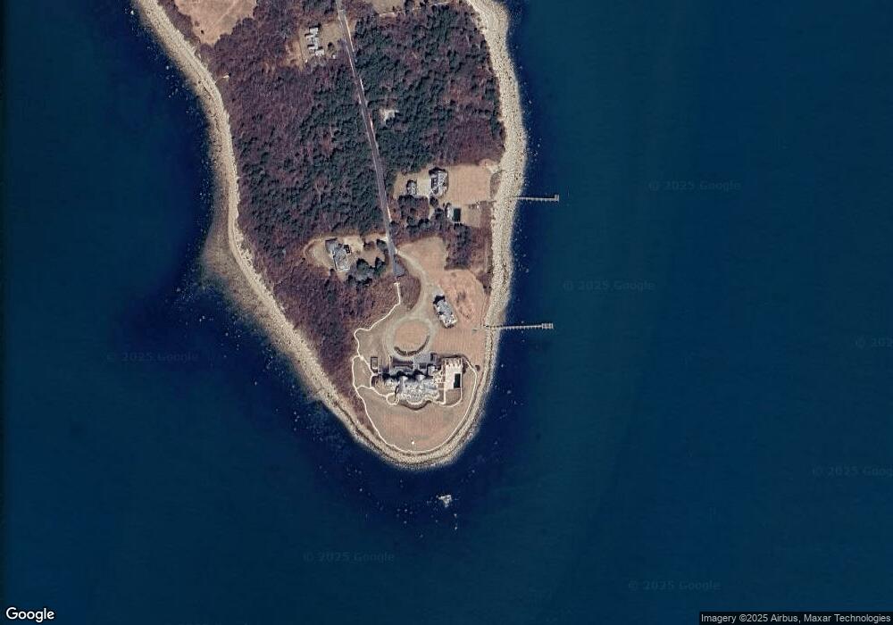
Map
Nearby Homes
- 158 Little River Rd
- 12 Meadow Shores Rd
- 24 Eagle Dr
- 62 Hetty Green St Unit 62
- 48 N Shore Dr Unit 3&7
- 48 N Shore Dr Unit 8
- 482 Smith Neck Rd
- Lot 1 Rafael Rd
- 24 White Alder Way
- 105 Rock Odundee Rd
- 61 Pardon Hill Rd
- Lot 2 Horseneck Rd
- 738 Smith Neck Rd
- Lot 2E Horseneck Rd
- 238-242 E Beach Rd
- 248 Bakerville Rd
- 23 High St
- 1150 Russells Mills Rd
- 40 School St
- 0 Stoneledge Rd
- 192 Mishaum Point Rd
- 192 Mishaum Point Rd
- 185 Mishaum Point Rd
- 188 Mishaum Point Rd
- 172 Mishaum Point Rd
- 169 Mishaum Point Rd
- 164 Mishaum Point Rd
- 163 Mishaum Point Rd
- 165 Mishaum Point Rd
- 165 Mishaum Point Rd Unit 1
- 160 Mishaum Point Rd
- 155 Mishaum Point Rd
- 156 Mishaum Point Rd
- 152 Mishaum Point Rd
- 147 Mishaum Point Rd
- 148 Mishaum Point Rd
- 144 Mishaum Point Rd
- 128 Mishaum Point Rd
- 124 Mishaum Point Rd
- 123 Mishaum Point Rd