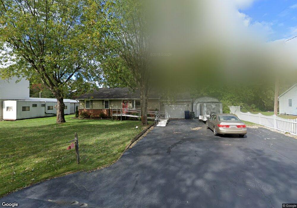
187 Sharp Rd Williamstown, NJ 08094
Monroe Township Gloucester NeighborhoodEstimated Value: $283,215 - $430,000
Studio
--
Bath
1,400
Sq Ft
$251/Sq Ft
Est. Value
About This Home
This home is located at 187 Sharp Rd, Williamstown, NJ 08094 and is currently estimated at $351,304, approximately $250 per square foot. 187 Sharp Rd is a home located in Gloucester County with nearby schools including Williamstown High School and Finest of the Wheat Christian.
Ownership History
Date
Name
Owned For
Owner Type
Purchase Details
Closed on
Jun 23, 2023
Sold by
Monroe Tool & Die Inc
Bought by
Monroe Tool & Die Inc
Current Estimated Value
Purchase Details
Closed on
Jun 20, 2023
Sold by
Kennedy Holly Lynn
Bought by
Monroe Tool & Die Inc
Purchase Details
Closed on
Jun 15, 2023
Sold by
Kennedy Holly Lynn
Bought by
Kennedy Holly Lynn
Purchase Details
Closed on
Nov 9, 2020
Sold by
Gingrich Robert W and Strulson Leslie Joan
Bought by
Kennedy Holly Lynn
Create a Home Valuation Report for This Property
The Home Valuation Report is an in-depth analysis detailing your home's value as well as a comparison with similar homes in the area
Home Values in the Area
Average Home Value in this Area
Purchase History
| Date | Buyer | Sale Price | Title Company |
|---|---|---|---|
| Monroe Tool & Die Inc | -- | None Listed On Document | |
| Monroe Tool & Die Inc | -- | None Listed On Document | |
| Kennedy Holly Lynn | -- | None Listed On Document | |
| Kennedy Holly Lynn | -- | None Listed On Document | |
| Kennedy Holly Lynn | -- | None Listed On Document | |
| Kennedy Holly Lynn | -- | None Listed On Document |
Source: Public Records
Tax History
| Year | Tax Paid | Tax Assessment Tax Assessment Total Assessment is a certain percentage of the fair market value that is determined by local assessors to be the total taxable value of land and additions on the property. | Land | Improvement |
|---|---|---|---|---|
| 2025 | $6,394 | $174,600 | $49,300 | $125,300 |
| 2024 | $6,372 | $174,600 | $49,300 | $125,300 |
| 2023 | $6,372 | $175,300 | $50,000 | $125,300 |
| 2022 | $6,342 | $175,300 | $50,000 | $125,300 |
| 2021 | $6,383 | $175,300 | $50,000 | $125,300 |
| 2020 | $6,376 | $175,300 | $50,000 | $125,300 |
| 2019 | $6,337 | $175,300 | $50,000 | $125,300 |
| 2018 | $6,234 | $175,300 | $50,000 | $125,300 |
| 2017 | $6,227 | $175,800 | $43,900 | $131,900 |
| 2016 | $5,898 | $175,800 | $43,900 | $131,900 |
| 2015 | $5,722 | $175,800 | $43,900 | $131,900 |
| 2014 | $5,548 | $175,800 | $43,900 | $131,900 |
Source: Public Records
Map
Nearby Homes
- 0 Old Black Horse Park
- 3908 Jackson Rd
- 4440 S Black Horse Pike
- 3109 Jackson Rd
- 0 W Ave
- 3042 S Black Horse Pike
- 2954 S Black Horse Pike
- 0 Cains Mill Rd Unit 598493
- 0 Cains Mill Rd Unit NJAC2018898
- 121 Delwyn Ln
- 107 Delwyn Ln
- 002 Castleton Dr
- 0 Whitehall Rd Unit NJGL2067450
- 003 Castleton Dr
- 004 Castleton Dr
- 723 Bayberry Ln
- 105 Delwyn Ln
- 347 Orange Ln
- 710 Whitehall Rd
- 167 New Hope Ln
Your Personal Tour Guide
Ask me questions while you tour the home.