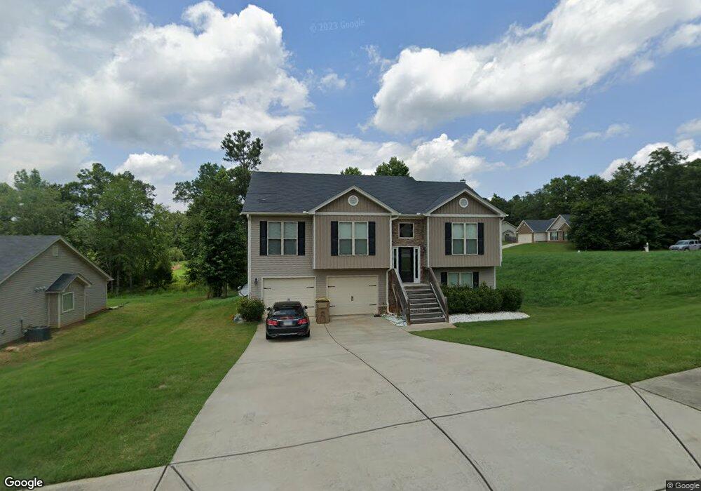
1871 Keri Ln Unit 50 Winder, GA 30680
Estimated Value: $379,000 - $441,000
4
Beds
3
Baths
2,200
Sq Ft
$183/Sq Ft
Est. Value
About This Home
This home is located at 1871 Keri Ln Unit 50, Winder, GA 30680 and is currently estimated at $402,342, approximately $182 per square foot. 1871 Keri Ln Unit 50 is a home located in Barrow County with nearby schools including Statham Elementary School, Bear Creek Middle School, and Winder-Barrow High School.
Ownership History
Date
Name
Owned For
Owner Type
Purchase Details
Closed on
Feb 3, 2017
Sold by
Southfork Homes Llc
Bought by
Callaway Tony
Current Estimated Value
Home Financials for this Owner
Home Financials are based on the most recent Mortgage that was taken out on this home.
Original Mortgage
$179,696
Outstanding Balance
$147,703
Interest Rate
4.2%
Mortgage Type
New Conventional
Estimated Equity
$254,639
Purchase Details
Closed on
Oct 17, 2016
Sold by
Sugarloaf East Llc
Bought by
Southfork Homs Llc
Purchase Details
Closed on
Dec 22, 2010
Sold by
State Bank & Trust Co
Bought by
Sugarloaf East Llc
Purchase Details
Closed on
Dec 7, 2009
Sold by
Lcs Llc
Bought by
State Bank & Trust Co
Purchase Details
Closed on
Aug 2, 2006
Sold by
Reece Deborah P
Bought by
Lcs Llc
Create a Home Valuation Report for This Property
The Home Valuation Report is an in-depth analysis detailing your home's value as well as a comparison with similar homes in the area
Home Values in the Area
Average Home Value in this Area
Purchase History
We collect this data history from publicly available records. To have your information removed, we recommend requesting removal directly through your county’s website.
| Date | Buyer | Sale Price | Title Company |
|---|---|---|---|
| Callaway Tony | $177,900 | -- | |
| Southfork Homs Llc | $147,000 | -- | |
| Sugarloaf East Llc | $3,700 | -- | |
| State Bank & Trust Co | -- | -- | |
| Lcs Llc | -- | -- |
Source: Public Records
Mortgage History
We collect this data history from publicly available records. To have your information removed, we recommend requesting removal directly through your county’s website.
| Date | Status | Borrower | Loan Amount |
|---|---|---|---|
| Open | Callaway Tony | $179,696 |
Source: Public Records
Tax History
| Year | Tax Paid | Tax Assessment Tax Assessment Total Assessment is a certain percentage of the fair market value that is determined by local assessors to be the total taxable value of land and additions on the property. | Land | Improvement |
|---|---|---|---|---|
| 2025 | $2,834 | $121,496 | $19,200 | $102,296 |
| 2024 | $2,933 | $118,570 | $19,200 | $99,370 |
| 2023 | $2,523 | $118,970 | $19,200 | $99,770 |
| 2022 | $3,073 | $104,922 | $19,200 | $85,722 |
| 2021 | $2,797 | $89,686 | $19,200 | $70,486 |
| 2020 | $2,528 | $80,392 | $16,000 | $64,392 |
| 2019 | $2,572 | $80,392 | $16,000 | $64,392 |
| 2018 | $2,358 | $74,144 | $12,800 | $61,344 |
| 2017 | $1,215 | $41,740 | $16,000 | $25,740 |
| 2016 | $323 | $7,680 | $7,680 | $0 |
| 2015 | $233 | $7,680 | $7,680 | $0 |
| 2014 | $82 | $2,600 | $2,600 | $0 |
| 2013 | -- | $2,600 | $2,600 | $0 |
Source: Public Records
Map
Nearby Homes
- 1948 Paynes Point
- 2333 Springside Dr
- 1295 Double Bridges Rd
- 1201 Bridge Crest Dr
- 207 Cedar Grove Church Rd
- 33 Cedar Grove Church Rd
- 1703 Bismarck Cir
- 1221 Bridge Crest Dr
- 0
- 47 Cedar Grove Church Rd
- 53 Cedar Grove Church Rd
- 15 Cedar Grove Church Rd
- 55 Cedar Grove Church Rd
- 41 Cedar Grove Church Rd
- 51 Cedar Grove Church Rd
- 21 Cedar Grove Church Rd
- 25 Cedar Grove Church Rd
- 45 Cedar Grove Church Rd
- 37 Cedar Grove Church Rd
- 9 Cedar Grove Church Rd
- 1871 Keri Ln
- 1873 Keri Ln Unit 49
- 1873 Keri Ln
- 1875 Keri Ln Unit 48
- 1875 Keri Ln
- 1740 Gresham Place Unit 51
- 1740 Gresham Place
- 1742 Gresham Place Unit 52
- 1742 Gresham Place Unit 11
- 1742 Gresham Place
- 1959 Paynes Point Unit 64
- 1959 Paynes Point
- 1957 Paynes Point Unit 65
- 1957 Paynes Point Unit 60
- 1957 Paynes Point
- 1870 Keri Ln Unit 42
- 1870 Keri Ln
- 1961 Paynes Point Unit 63
- 1961 Paynes Point
- 1872 Keri Ln Unit 43
Your Personal Tour Guide
Ask me questions while you tour the home.