Estimated Value: $386,000 - $543,000
3
Beds
2
Baths
1,798
Sq Ft
$252/Sq Ft
Est. Value
About This Home
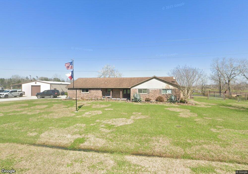
This home is located at 1874 County Road 936b, Alvin, TX 77511 and is currently estimated at $453,351, approximately $252 per square foot. 1874 County Road 936b is a home located in Brazoria County with nearby schools including Hood-Case Elementary School, G.W. Harby Junior High School, and Alvin High School.
Ownership History
Date
Name
Owned For
Owner Type
Purchase Details
Closed on
Nov 21, 2007
Sold by
Perry Helen
Bought by
Clark Charles D
Current Estimated Value
Home Financials for this Owner
Home Financials are based on the most recent Mortgage that was taken out on this home.
Original Mortgage
$180,000
Outstanding Balance
$114,123
Interest Rate
6.42%
Mortgage Type
Purchase Money Mortgage
Estimated Equity
$339,228
Purchase Details
Closed on
Aug 23, 2006
Sold by
Cruikshank Kenneth M and Cruikshank Kenneth
Bought by
Perry Helen
Create a Home Valuation Report for This Property
The Home Valuation Report is an in-depth analysis detailing your home's value as well as a comparison with similar homes in the area
Home Values in the Area
Average Home Value in this Area
Purchase History
| Date | Buyer | Sale Price | Title Company |
|---|---|---|---|
| Clark Charles D | -- | Texas American Title Company | |
| Perry Helen | -- | Stewart Title Brazoria |
Source: Public Records
Mortgage History
| Date | Status | Borrower | Loan Amount |
|---|---|---|---|
| Open | Clark Charles D | $180,000 |
Source: Public Records
Tax History Compared to Growth
Tax History
| Year | Tax Paid | Tax Assessment Tax Assessment Total Assessment is a certain percentage of the fair market value that is determined by local assessors to be the total taxable value of land and additions on the property. | Land | Improvement |
|---|---|---|---|---|
| 2025 | $4,533 | $413,610 | $185,760 | $227,850 |
| 2023 | $4,533 | $293,616 | $219,510 | $260,050 |
| 2022 | $5,640 | $264,696 | $199,670 | $204,070 |
| 2021 | $5,340 | $264,790 | $45,530 | $219,260 |
| 2020 | $4,919 | $221,660 | $30,350 | $191,310 |
| 2019 | $4,604 | $198,870 | $30,350 | $168,520 |
| 2018 | $4,357 | $187,710 | $30,350 | $157,360 |
| 2017 | $4,028 | $171,470 | $30,350 | $141,120 |
| 2016 | $4,634 | $197,250 | $39,460 | $157,790 |
| 2014 | $3,961 | $186,620 | $30,350 | $156,270 |
Source: Public Records
Map
Nearby Homes
- 1816 County Road 936b
- 1871 County Road 936
- 3046 County Road 529
- 1688 County Road 144
- 1690 County Road 965
- 1695 County Road 965
- 2257 County Road 529
- 2052 County Road 540
- 1950 County Road 540
- 000 Herring at Cr 144 Rd
- 1236 County Road 634
- 0 County Road 540
- 4738 Alluvial Cir
- 726 Rim Water Dr
- 4724 Alluvial Cir
- 4706 Alluvial Cir
- 1259 County Road 147
- 349 Lake Line Dr
- 432 Kendall Crest Dr
- 415 Kendall Crest Dr
- 936B County Road 936b
- 1885 County Road 936b
- 2891 County Road 936c
- 2874 County Road 936a
- 2889 County Road 936a
- 2889 County Road 936a
- 2873 County Road 936c
- 2862 County Road 936a
- 1802 County Road 936c
- 2877 County Road 936a
- 0 County Road 936a
- 2865 County Road 936a
- 2896 County Road 936c
- 2847 County Road 936c
- 2874 County Road 936c
- 2834 County Road 936a
- 2839 County Road 936c
- 529 County Road 529
- 2833 County Road 936a
- 936C County Road 936c