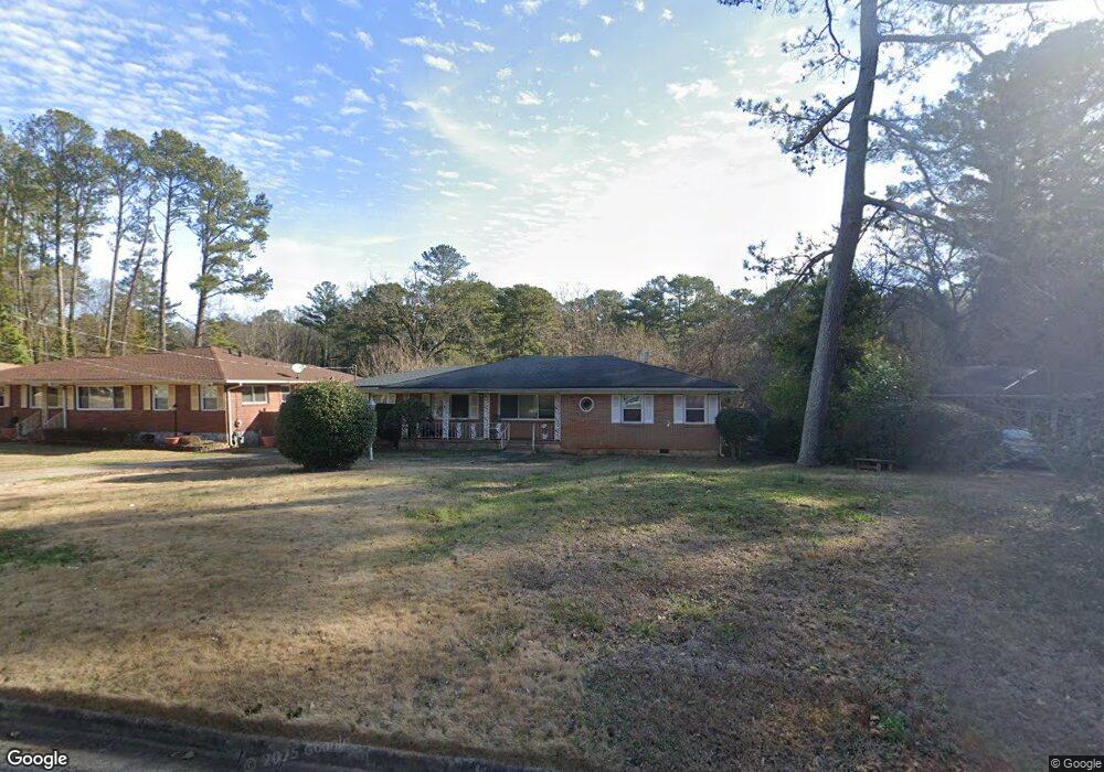
1874 Shepherd Cir SW Atlanta, GA 30311
Estimated Value: $237,840 - $344,000
4
Beds
2
Baths
1,560
Sq Ft
$188/Sq Ft
Est. Value
About This Home
This home is located at 1874 Shepherd Cir SW, Atlanta, GA 30311 and is currently estimated at $293,960, approximately $188 per square foot. 1874 Shepherd Cir SW is a home located in Fulton County with nearby schools including Tuskegee Airman Global Academy, Herman J. Russell West End Academy, and Booker T. Washington High School.
Ownership History
Date
Name
Owned For
Owner Type
Purchase Details
Closed on
Jul 13, 2010
Sold by
Long Beach Trust 2004 & 1
Bought by
Scsj Investments Llc
Current Estimated Value
Purchase Details
Closed on
Jan 5, 2010
Sold by
Martin Darren and Martin Laura
Bought by
Long Beach Trust 2004 & 1
Purchase Details
Closed on
Jun 25, 2003
Sold by
Smith Mary F E
Bought by
Martin Darren
Home Financials for this Owner
Home Financials are based on the most recent Mortgage that was taken out on this home.
Original Mortgage
$92,000
Interest Rate
5.29%
Create a Home Valuation Report for This Property
The Home Valuation Report is an in-depth analysis detailing your home's value as well as a comparison with similar homes in the area
Home Values in the Area
Average Home Value in this Area
Purchase History
| Date | Buyer | Sale Price | Title Company |
|---|---|---|---|
| Scsj Investments Llc | $45,000 | -- | |
| Long Beach Trust 2004 & 1 | $51,000 | -- | |
| Martin Darren | $97,000 | -- |
Source: Public Records
Mortgage History
| Date | Status | Borrower | Loan Amount |
|---|---|---|---|
| Previous Owner | Martin Darren | $92,000 |
Source: Public Records
Tax History Compared to Growth
Tax History
| Year | Tax Paid | Tax Assessment Tax Assessment Total Assessment is a certain percentage of the fair market value that is determined by local assessors to be the total taxable value of land and additions on the property. | Land | Improvement |
|---|---|---|---|---|
| 2025 | $2,498 | $88,680 | $23,240 | $65,440 |
| 2023 | $3,242 | $78,320 | $22,880 | $55,440 |
| 2022 | $2,020 | $78,320 | $22,880 | $55,440 |
| 2021 | $2,022 | $49,920 | $10,880 | $39,040 |
| 2020 | $2,020 | $49,320 | $10,760 | $38,560 |
| 2019 | $491 | $20,320 | $4,520 | $15,800 |
| 2018 | $823 | $19,880 | $4,440 | $15,440 |
| 2017 | $489 | $11,320 | $3,120 | $8,200 |
| 2016 | $490 | $11,320 | $3,120 | $8,200 |
| 2015 | $983 | $11,320 | $3,120 | $8,200 |
| 2014 | $513 | $11,320 | $3,120 | $8,200 |
Source: Public Records
Map
Nearby Homes
- 1905 Fort Valley Dr SW
- 1806 Fort Valley Dr SW
- 2357 Bayrose Cir Unit 57B
- 3002 Bayrose Cir
- 1826 Bayrose Cir
- 1829 Bayrose Cir
- 3111 Bayrose Cir
- 3111 Bayrose Cir Unit 109B
- 1723 Fort Valley Dr SW
- 6034 Bayrose Cir
- 1925 Campbellton Rd SW
- 1762 Hadlock St SW
- 1735 Carter Cir
- 1780 Delowe Dr SW
- 1005 Bayrose Cir
- 2028 Dewberry Ln
- 1724 Leslie Ave SW
- 1882 Shepherd Cir SW Unit 1
- 1868 Shepherd Cir SW
- 1890 Shepherd Cir SW Unit 1
- 1860 Shepherd Cir SW
- 1877 Fort Valley Dr SW
- 1869 Fort Valley Dr SW
- 1861 Fort Valley Dr SW
- 1898 Shepherd Cir SW
- 1875 Shepherd Cir SW
- 1852 Shepherd Cir SW
- 1869 Shepherd Cir SW
- 1891 Fort Valley Dr SW
- 1883 Shepherd Cir SW
- 0 Fort Valley Dr SW Unit 8645817
- 0 Fort Valley Dr SW Unit 8580055
- 0 Fort Valley Dr SW Unit 8456907
- 0 Fort Valley Dr SW Unit 8373752
- 0 Fort Valley Dr SW Unit 8237340
- 0 Fort Valley Dr SW Unit 8134459
- 0 Fort Valley Dr SW Unit 7573521