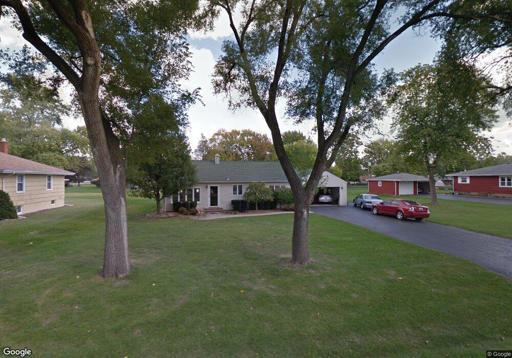
18743 Walter St Lansing, IL 60438
Estimated Value: $164,269 - $209,000
2
Beds
1
Bath
1,176
Sq Ft
$158/Sq Ft
Est. Value
About This Home
This home is located at 18743 Walter St, Lansing, IL 60438 and is currently estimated at $186,317, approximately $158 per square foot. 18743 Walter St is a home located in Cook County with nearby schools including Nathan Hale Elementary School, Heritage Middle School, and Thornton Fractnl So High School.
Ownership History
Date
Name
Owned For
Owner Type
Purchase Details
Closed on
Aug 10, 2017
Sold by
Gunty Amanda and Gunty Justin
Bought by
Gall David J and Ward Julie M
Current Estimated Value
Home Financials for this Owner
Home Financials are based on the most recent Mortgage that was taken out on this home.
Original Mortgage
$100,152
Outstanding Balance
$84,449
Interest Rate
4.62%
Mortgage Type
FHA
Estimated Equity
$101,868
Purchase Details
Closed on
May 6, 2010
Sold by
Brennan Denis D and Brennan Laurie A
Bought by
Carter Amanda
Home Financials for this Owner
Home Financials are based on the most recent Mortgage that was taken out on this home.
Original Mortgage
$103,098
Interest Rate
5.25%
Mortgage Type
FHA
Purchase Details
Closed on
Jan 29, 2008
Sold by
Brennan Denis D and Brennan Laurie A
Bought by
Brennan Denis D and Brennan Laurie A
Purchase Details
Closed on
Jun 10, 1994
Sold by
Lynch Daniel T and Lynch Janet M
Bought by
Brennan Denis D
Home Financials for this Owner
Home Financials are based on the most recent Mortgage that was taken out on this home.
Original Mortgage
$85,000
Interest Rate
8.58%
Create a Home Valuation Report for This Property
The Home Valuation Report is an in-depth analysis detailing your home's value as well as a comparison with similar homes in the area
Home Values in the Area
Average Home Value in this Area
Purchase History
| Date | Buyer | Sale Price | Title Company |
|---|---|---|---|
| Gall David J | $102,000 | Attorney | |
| Carter Amanda | $105,000 | Ticor Title Insurance Co | |
| Brennan Denis D | -- | None Available | |
| Brennan Denis D | $90,000 | -- |
Source: Public Records
Mortgage History
| Date | Status | Borrower | Loan Amount |
|---|---|---|---|
| Open | Gall David J | $100,152 | |
| Previous Owner | Carter Amanda | $103,098 | |
| Previous Owner | Brennan Denis D | $85,000 |
Source: Public Records
Tax History
| Year | Tax Paid | Tax Assessment Tax Assessment Total Assessment is a certain percentage of the fair market value that is determined by local assessors to be the total taxable value of land and additions on the property. | Land | Improvement |
|---|---|---|---|---|
| 2025 | $3,129 | $10,651 | $4,017 | $6,634 |
| 2024 | $3,129 | $10,651 | $4,017 | $6,634 |
| 2023 | $2,717 | $10,651 | $4,017 | $6,634 |
| 2022 | $2,717 | $8,050 | $6,026 | $2,024 |
| 2021 | $2,670 | $8,048 | $6,025 | $2,023 |
| 2020 | $2,619 | $8,048 | $6,025 | $2,023 |
| 2019 | $5,308 | $10,266 | $5,523 | $4,743 |
| 2018 | $5,162 | $10,266 | $5,523 | $4,743 |
| 2017 | $3,392 | $10,266 | $5,523 | $4,743 |
| 2016 | $3,238 | $9,253 | $5,021 | $4,232 |
| 2015 | $3,080 | $9,253 | $5,021 | $4,232 |
| 2014 | $3,033 | $9,253 | $5,021 | $4,232 |
| 2013 | $3,275 | $10,584 | $5,021 | $5,563 |
Source: Public Records
Map
Nearby Homes
- 3225 Otto St
- 18747 Sherman St
- 3310 186th St
- 18855 Burnham Ave Unit 234
- 18828 Greenbay Ave
- 3240 N Manor Dr Unit 216
- 3240 N Manor Dr Unit 130
- 18634 Bernadine St
- 18864 Greenbay Ave
- 3235 S Manor Dr Unit 104
- 3363 S Manor Dr
- 3518 S Manor Dr
- 3316 Ann St
- 18905 Park Ave
- 18504 Wentworth Ave
- 3320 191st St
- 3620 186th St Unit 405
- 3034 190th St
- 3640 186th St Unit 101
- 18324 Roy St
Your Personal Tour Guide
Ask me questions while you tour the home.