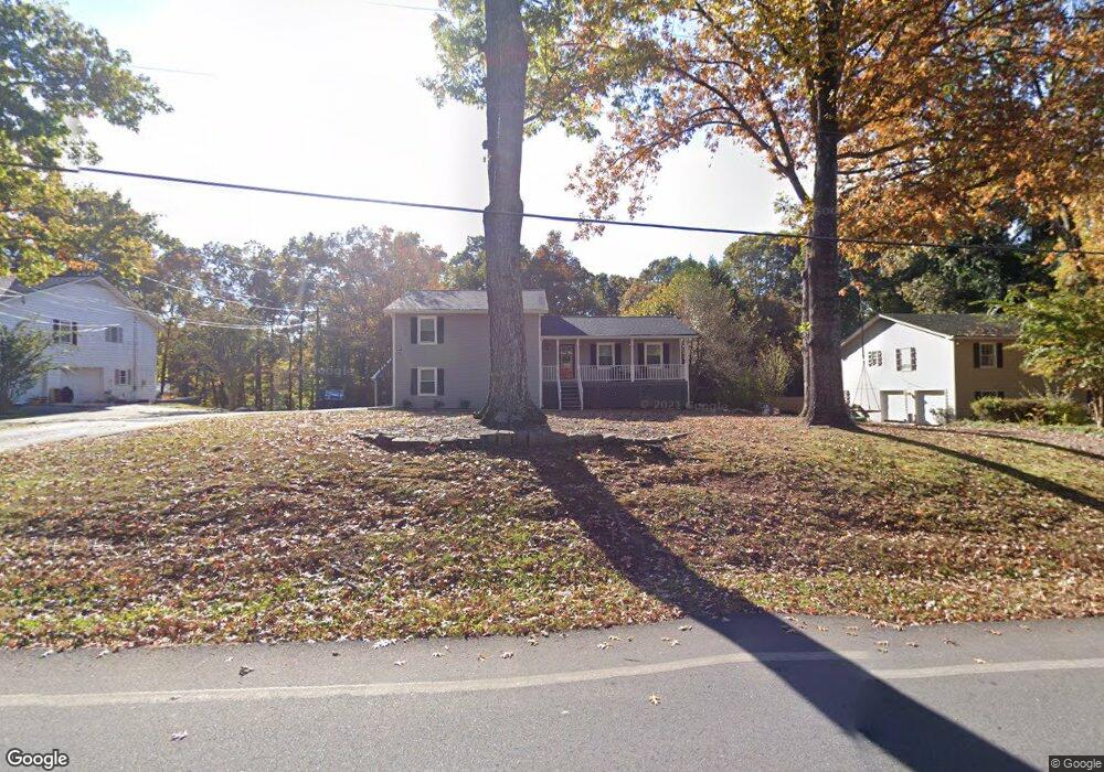
1875 Britt Dr Snellville, GA 30078
Estimated Value: $328,994 - $405,000
3
Beds
3
Baths
1,582
Sq Ft
$232/Sq Ft
Est. Value
About This Home
This home is located at 1875 Britt Dr, Snellville, GA 30078 and is currently estimated at $366,749, approximately $231 per square foot. 1875 Britt Dr is a home located in Gwinnett County with nearby schools including Head Elementary School, Five Forks Middle School, and Brookwood High School.
Ownership History
Date
Name
Owned For
Owner Type
Purchase Details
Closed on
May 24, 2017
Sold by
Thomas Anita
Bought by
Gates Kelli A
Current Estimated Value
Home Financials for this Owner
Home Financials are based on the most recent Mortgage that was taken out on this home.
Original Mortgage
$176,739
Outstanding Balance
$147,713
Interest Rate
4.37%
Mortgage Type
FHA
Estimated Equity
$219,036
Create a Home Valuation Report for This Property
The Home Valuation Report is an in-depth analysis detailing your home's value as well as a comparison with similar homes in the area
Home Values in the Area
Average Home Value in this Area
Purchase History
| Date | Buyer | Sale Price | Title Company |
|---|---|---|---|
| Gates Kelli A | $180,000 | -- |
Source: Public Records
Mortgage History
| Date | Status | Borrower | Loan Amount |
|---|---|---|---|
| Open | Gates Kelli A | $176,739 |
Source: Public Records
Tax History Compared to Growth
Tax History
| Year | Tax Paid | Tax Assessment Tax Assessment Total Assessment is a certain percentage of the fair market value that is determined by local assessors to be the total taxable value of land and additions on the property. | Land | Improvement |
|---|---|---|---|---|
| 2025 | $3,688 | $105,680 | $24,000 | $81,680 |
| 2024 | $3,786 | $105,680 | $24,000 | $81,680 |
| 2023 | $3,786 | $105,680 | $24,000 | $81,680 |
| 2022 | $3,496 | $93,520 | $12,000 | $81,520 |
| 2021 | $3,543 | $93,520 | $12,000 | $81,520 |
| 2020 | $3,786 | $93,520 | $12,000 | $81,520 |
| 2019 | $2,710 | $66,560 | $10,000 | $56,560 |
| 2018 | $2,709 | $66,560 | $10,000 | $56,560 |
| 2016 | $2,726 | $66,560 | $10,000 | $56,560 |
| 2015 | $2,354 | $55,160 | $8,000 | $47,160 |
| 2014 | $2,365 | $55,160 | $8,000 | $47,160 |
Source: Public Records
Map
Nearby Homes
- 1904 Britt Dr
- 1721 Bruckner Ct
- 1795 Elmwood Cir
- 2350 Action Way
- 3207 Aspen Cir SW
- 2034 Britt Dr
- 2167 Foley Park St
- 2286 Foley Park St
- 1893 Hedgestone Ct
- 3594 Hedgestone Ln
- 3063 Bruckner Blvd
- 1845 Lisa Springs Dr
- 3588 Kelin Ct SW
- 1916 Oakwood Grove Dr Unit 1
- 3728 Kelin Ct SW
- Kenwood Plan at Watson Park
- Stockbridge Plan at Watson Park
- Aiken Plan at Watson Park
- Lawrence Plan at Watson Park
- Easton Plan at Watson Park
- 1865 Britt Dr
- 1885 Britt Dr
- 1855 Britt Dr
- 3309 Maple Dr
- 3323 Crossing Dr Unit 2
- 3339 Maple Dr
- 3362 Crossing Dr SW
- 3313 Crossing Dr
- 3362 Crossing Dr Unit 2
- 3302 Cottonwood Ln Unit 1
- 3312 Cottonwood Ln Unit 1
- 3303 Crossing Dr
- 3322 Cottonwood Ln Unit 1
- 3293 Crossing Dr Unit 2
- 3352 Crossing Dr
- 3349 Maple Dr
- 3310 Maple Dr Unit A
- 3310 Maple Dr
- 3283 Crossing Dr
- 1835 Britt Dr