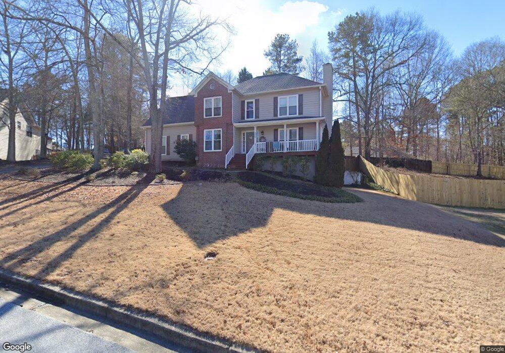
1878 Brookhill Way Snellville, GA 30078
Estimated Value: $350,000 - $407,000
3
Beds
3
Baths
2,053
Sq Ft
$186/Sq Ft
Est. Value
About This Home
This home is located at 1878 Brookhill Way, Snellville, GA 30078 and is currently estimated at $381,645, approximately $185 per square foot. 1878 Brookhill Way is a home located in Gwinnett County with nearby schools including Britt Elementary School, Snellville Middle School, and South Gwinnett High School.
Ownership History
Date
Name
Owned For
Owner Type
Purchase Details
Closed on
Dec 15, 1997
Sold by
Wakenigg Richard D and Wakenigg Laura D
Bought by
Kempf Jay D and Kempf Patricia N
Current Estimated Value
Home Financials for this Owner
Home Financials are based on the most recent Mortgage that was taken out on this home.
Original Mortgage
$128,000
Outstanding Balance
$20,169
Interest Rate
7.23%
Mortgage Type
VA
Estimated Equity
$361,476
Create a Home Valuation Report for This Property
The Home Valuation Report is an in-depth analysis detailing your home's value as well as a comparison with similar homes in the area
Home Values in the Area
Average Home Value in this Area
Purchase History
| Date | Buyer | Sale Price | Title Company |
|---|---|---|---|
| Kempf Jay D | $128,000 | -- |
Source: Public Records
Mortgage History
| Date | Status | Borrower | Loan Amount |
|---|---|---|---|
| Open | Kempf Jay D | $128,000 |
Source: Public Records
Tax History Compared to Growth
Tax History
| Year | Tax Paid | Tax Assessment Tax Assessment Total Assessment is a certain percentage of the fair market value that is determined by local assessors to be the total taxable value of land and additions on the property. | Land | Improvement |
|---|---|---|---|---|
| 2025 | $489 | $156,800 | $30,000 | $126,800 |
| 2024 | $3,470 | $148,760 | $30,000 | $118,760 |
| 2023 | $3,470 | $153,720 | $29,680 | $124,040 |
| 2022 | $3,225 | $136,200 | $20,000 | $116,200 |
| 2021 | $2,520 | $98,800 | $14,000 | $84,800 |
| 2020 | $2,664 | $84,400 | $12,000 | $72,400 |
| 2019 | $2,660 | $84,400 | $12,000 | $72,400 |
| 2018 | $2,489 | $77,440 | $10,000 | $67,440 |
| 2016 | $2,151 | $64,520 | $10,000 | $54,520 |
| 2015 | $1,867 | $53,760 | $8,000 | $45,760 |
| 2014 | -- | $53,760 | $8,000 | $45,760 |
Source: Public Records
Map
Nearby Homes
- 2655 Lake Commons Ct
- Atlas Plan at Oak Grove Glen
- Travis Plan at Oak Grove Glen
- Harding Plan at Oak Grove Glen
- 2009 Brookhill Way
- 2019 Brookhill Way
- 2029 Brookhill Way
- 2020 Jayson Way
- 2039 Brookhill Way
- 2049 Brookhill Way
- 2059 Brookhill Way
- 2922 Sunrise Ridge Rd
- 2069 Brookhill Way
- 1601 Rockdale Cir
- 2078 Brookhill Way SW
- 2079 Brookhill Way
- 2862 Sunrise Ridge Rd
- 2862 Sunrise Ridge Rd Unit LOT 29
- 2852 Sunrise Ridge Rd Unit LOT 30
- 2852 Sunrise Ridge Rd
- 1888 Brookhill Way Unit 2
- 1868 Brookhill Way
- 2900 Splitwood Dr Unit 1
- 2920 Splitwood Dr
- 1859 Brookhill Way
- 1879 Brookhill Way
- 2905 Splitwood Dr Unit 1
- 1898 Brookhill Way
- 2930 Splitwood Dr
- 1869 Brookhill Way
- 1899 Brookhill Way
- 1882 Commons View Cir
- 1800 Rockside Ln
- 2915 Splitwood Dr Unit 276
- 2915 Splitwood Dr Unit I
- 2915 Splitwood Dr Unit 1
- 1908 Brookhill Way
- 2940 Splitwood Dr
- 1892 Commons View Cir
- 2935 Splitwood Dr