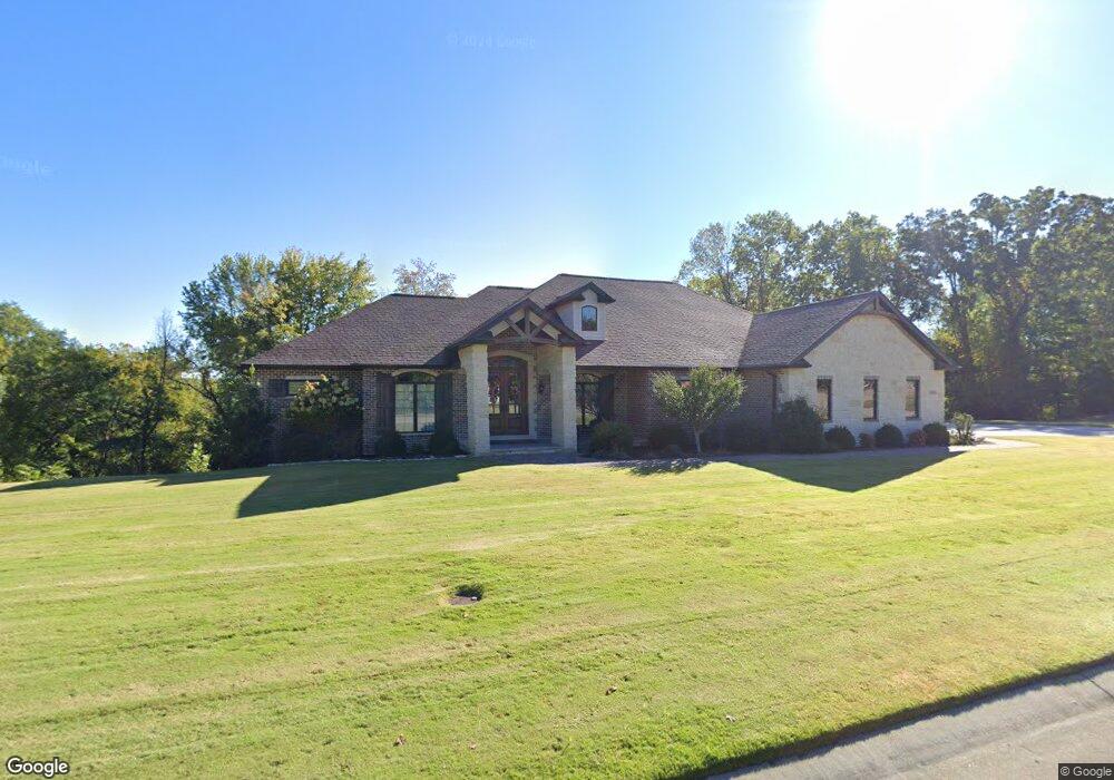
1878 Silverthorne Trail Cape Girardeau, MO 63701
Estimated Value: $515,000 - $975,000
5
Beds
3
Baths
3,728
Sq Ft
$210/Sq Ft
Est. Value
About This Home
This home is located at 1878 Silverthorne Trail, Cape Girardeau, MO 63701 and is currently estimated at $781,876, approximately $209 per square foot. 1878 Silverthorne Trail is a home located in Cape Girardeau County with nearby schools including Clippard Elementary School, Central Middle School, and Central Junior High School.
Ownership History
Date
Name
Owned For
Owner Type
Purchase Details
Closed on
Mar 14, 2024
Sold by
Beckham Qualified Spousal Trust
Bought by
Tinsley Trust
Current Estimated Value
Purchase Details
Closed on
Apr 1, 2020
Sold by
Blank Robert Scott
Bought by
Beckham Donald D and Beckham Qualified Spousal Trust
Home Financials for this Owner
Home Financials are based on the most recent Mortgage that was taken out on this home.
Original Mortgage
$425,000
Interest Rate
3.2%
Mortgage Type
Commercial
Create a Home Valuation Report for This Property
The Home Valuation Report is an in-depth analysis detailing your home's value as well as a comparison with similar homes in the area
Home Values in the Area
Average Home Value in this Area
Purchase History
| Date | Buyer | Sale Price | Title Company |
|---|---|---|---|
| Tinsley Trust | -- | None Listed On Document | |
| Beckham Donald D | -- | None Available | |
| Beckham Donald D | -- | None Available |
Source: Public Records
Mortgage History
| Date | Status | Borrower | Loan Amount |
|---|---|---|---|
| Previous Owner | Beckham Donald D | $425,000 |
Source: Public Records
Tax History Compared to Growth
Tax History
| Year | Tax Paid | Tax Assessment Tax Assessment Total Assessment is a certain percentage of the fair market value that is determined by local assessors to be the total taxable value of land and additions on the property. | Land | Improvement |
|---|---|---|---|---|
| 2025 | $58 | $118,060 | $27,100 | $90,960 |
| 2024 | $58 | $112,430 | $25,810 | $86,620 |
| 2023 | $5,843 | $112,430 | $25,810 | $86,620 |
| 2022 | $5,389 | $103,630 | $23,790 | $79,840 |
| 2021 | $5,388 | $103,630 | $23,790 | $79,840 |
| 2020 | $5,404 | $103,630 | $23,790 | $79,840 |
| 2019 | $5,396 | $103,630 | $0 | $0 |
| 2018 | $5,385 | $103,630 | $0 | $0 |
| 2017 | $5,398 | $103,630 | $0 | $0 |
| 2016 | $5,195 | $100,130 | $0 | $0 |
| 2015 | $765 | $14,740 | $0 | $0 |
| 2014 | $769 | $14,740 | $0 | $0 |
Source: Public Records
Map
Nearby Homes
- 1800 Silverthorne Trail
- 1969 Silverthorne Trail
- 1989 Silverthorne Trail
- 2236 Boulder Crest Dr
- 3814 Carolewood Dr
- 1356 Holly Dr
- 3046 Beavercreek Dr
- 3022 Beavercreek Dr
- 2923 Pine Hill Spur
- 2929 Pine Hill Spur
- 2161 Esker Trail
- 2153 Esker Trail
- 2325 Brister Hill Dr
- 2253 Heywood Meadows
- 3036 Keystone Dr
- 2640 Walden Blvd
- 3466 Hopper Rd
- 2224 Heywood Meadows
- 2975 Pine Hill Spur
- 2960 Pine Hill Spur
- 1855 Silverthorne Trail
- 1881 Silverthorne Trail
- 1957 Silverthorne Trail
- 1840 Silverthorne Trail
- 1833 Silverthorne Trail
- 1823 Silverthorne Trail
- 1923 Silverthorne Trail
- 1927 N Kingshighway St
- 12Lot Silverthorne Trail
- 1330 Kenwood Dr
- 1810 Silverthorne Trail
- 1326 Kenwood Dr
- 1804 Silverthorne Trail
- 1325 Kenwood Dr
- 1322 Kenwood Dr
- 1342 Ashland Hills Dr
- 1321 Kenwood Dr
- 3212 Kage Hill Dr
- 1938 Silverthorne Trail
- 1338 Ashland Hills Dr