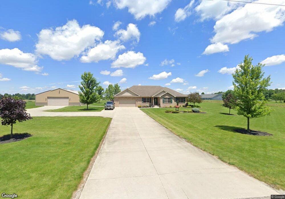
1880 Cisco Rd Sidney, OH 45365
Estimated Value: $417,000 - $466,000
3
Beds
2
Baths
2,941
Sq Ft
$150/Sq Ft
Est. Value
About This Home
This home is located at 1880 Cisco Rd, Sidney, OH 45365 and is currently estimated at $440,226, approximately $149 per square foot. 1880 Cisco Rd is a home located in Shelby County with nearby schools including Sidney High School, Holy Angels Catholic School, and Christian Academy Schools.
Ownership History
Date
Name
Owned For
Owner Type
Purchase Details
Closed on
Apr 25, 2017
Sold by
Hensley Anthony S and Hensley Krista L
Bought by
Green John B and Green Shanda L
Current Estimated Value
Home Financials for this Owner
Home Financials are based on the most recent Mortgage that was taken out on this home.
Original Mortgage
$264,127
Outstanding Balance
$216,969
Interest Rate
3.75%
Mortgage Type
FHA
Estimated Equity
$223,257
Purchase Details
Closed on
May 21, 2002
Sold by
Mc Dev Ltd
Bought by
Hensley Anthony and Hensley Krista L
Home Financials for this Owner
Home Financials are based on the most recent Mortgage that was taken out on this home.
Original Mortgage
$129,500
Interest Rate
7.16%
Mortgage Type
New Conventional
Purchase Details
Closed on
Aug 3, 2001
Sold by
Helman Ronald G
Bought by
Mc Development Ltd
Create a Home Valuation Report for This Property
The Home Valuation Report is an in-depth analysis detailing your home's value as well as a comparison with similar homes in the area
Home Values in the Area
Average Home Value in this Area
Purchase History
| Date | Buyer | Sale Price | Title Company |
|---|---|---|---|
| Green John B | $269,000 | Attorney | |
| Hensley Anthony | $161,900 | -- | |
| Mc Development Ltd | $50,000 | -- |
Source: Public Records
Mortgage History
| Date | Status | Borrower | Loan Amount |
|---|---|---|---|
| Open | Green John B | $264,127 | |
| Previous Owner | Hensley Anthony | $129,500 |
Source: Public Records
Tax History Compared to Growth
Tax History
| Year | Tax Paid | Tax Assessment Tax Assessment Total Assessment is a certain percentage of the fair market value that is determined by local assessors to be the total taxable value of land and additions on the property. | Land | Improvement |
|---|---|---|---|---|
| 2024 | $4,313 | $124,110 | $13,590 | $110,520 |
| 2023 | $4,313 | $124,110 | $13,590 | $110,520 |
| 2022 | $3,776 | $94,580 | $11,010 | $83,570 |
| 2021 | $3,814 | $94,580 | $11,010 | $83,570 |
| 2020 | $3,814 | $94,580 | $11,010 | $83,570 |
| 2019 | $3,352 | $84,240 | $9,030 | $75,210 |
| 2018 | $3,287 | $84,240 | $9,030 | $75,210 |
| 2017 | $3,307 | $84,240 | $9,030 | $75,210 |
| 2016 | $2,816 | $72,310 | $7,400 | $64,910 |
| 2015 | $2,733 | $69,980 | $7,400 | $62,580 |
| 2014 | $2,733 | $69,980 | $7,400 | $62,580 |
| 2013 | $3,195 | $75,420 | $7,400 | $68,020 |
Source: Public Records
Map
Nearby Homes
- 615 Addy Ave
- 634 Addy Ave
- 662 Addy Ave
- 676 Addy Ave
- 648 Addy Ave
- 1556 Knights Way
- 1560 Target Dr
- Spruce w/ Full Basement Plan at Burr Oak Mill
- Elder w/ Full Basement Plan at Burr Oak Mill
- Cedar w/ Full Basement Plan at Burr Oak Mill
- Birch w/ Full Basement Plan at Burr Oak Mill
- Aspen Plan at Burr Oak Mill
- 1355 Gray Oak Dr
- 1414 Gray Oak Dr
- 1514 Knights Way
- 0 Windsor Park
- 2360 Wapakoneta Ave Unit 106
- 0 Sunshine Dr
- 1624 Holly Place
- 128 Village Green Dr
- 1900 Cisco Rd
- 1840 Cisco Rd
- 1841 Cisco Rd
- 1820 Cisco Rd
- 2785 State Route 29 N
- 2785 Ohio 29
- 1897 Cisco Rd
- 1881 Cisco Rd
- 2613 State Route 29 N
- 2815 State Route 29 N
- 2784 State Route 29 N
- 2599 State Route 29 N
- 2672 State Route 29 N
- 2814 State Route 29 N
- 2848 State Route 29 N
- 2848 Ohio 29
- 2845 State Route 29 N
- 2845 St Rt 29 W
- 2845 Ohio 29
- 2616 State Route 29 N