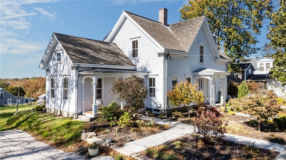
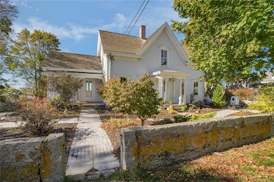

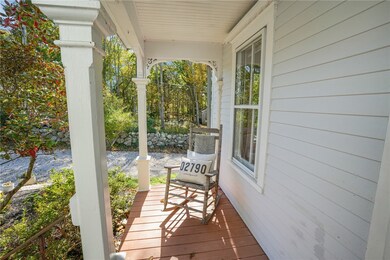
1881 Main Rd Westport, MA 02790
Westport Point NeighborhoodEstimated payment $9,096/month
Highlights
- Marina
- Golf Course Community
- Wood Flooring
- Water Views
- Antique Architecture
- Attic
About This Home
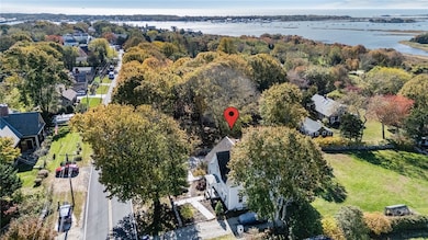
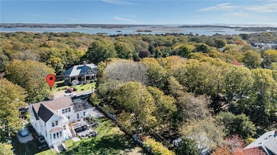
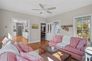
Located in the highly desirable Westport Point area, The Tripp-Sowle House seamlessly combines classic New England architecture with modern luxury. Listed on the National Register of Historic Places, this distinguished home has been fully restored with contemporary amenities while preserving its timeless character. The stunning kitchen features marble countertops, custom Belmont cabinetry, a convection wall oven, and a spacious walk-in pantry ideal for the modern entertainer. Wide-plank white oak floors, renovated bathrooms, and central A/C ensure year-round comfort. Behind its historic fa ade, all major systems have been thoughtfully updated, including a newer septic (2020), new electrical service, well pump, water purification system, and Buderus boiler. The serene primary suite opens to a private balcony with distant water views and gorgeous sunsets. Enjoy an outdoor shower after a day at the beach and take in the serenity of this coveted coastal community. Surrounded by classic cut granite walls and the beauty of Westport Point's most picturesque enclave, this home embodies refined luxury living at its finest.Just over an hour from Boston and minutes to the area's pristine beaches & restaurants. The perfect home for year round living or a seasonal serene escape.
Home Details
Home Type
- Single Family
Est. Annual Taxes
- $8,280
Year Built
- Built in 1820
Lot Details
- 0.5 Acre Lot
Home Design
- Antique Architecture
- Stone Foundation
- Wood Siding
- Concrete Perimeter Foundation
- Clapboard
- Plaster
Interior Spaces
- 2,600 Sq Ft Home
- 2-Story Property
- Central Vacuum
- Thermal Windows
- Workshop
- Storage Room
- Utility Room
- Wood Flooring
- Water Views
- Attic
Kitchen
- Walk-In Pantry
- Convection Oven
- Range with Range Hood
- Microwave
- Dishwasher
Bedrooms and Bathrooms
- 4 Bedrooms
- 3 Full Bathrooms
- Bathtub with Shower
Laundry
- Dryer
- Washer
Unfinished Basement
- Basement Fills Entire Space Under The House
- Interior and Exterior Basement Entry
Home Security
- Storm Windows
- Storm Doors
Parking
- 4 Parking Spaces
- No Garage
Outdoor Features
- Walking Distance to Water
- Porch
Utilities
- Zoned Heating and Cooling System
- Heating System Uses Gas
- 200+ Amp Service
- Private Water Source
- Well
- Gas Water Heater
- Septic Tank
- Cable TV Available
Listing and Financial Details
- Tax Lot 66
- Assessor Parcel Number 1881MAINRDWPOT
Community Details
Overview
- Westport Point Subdivision
Amenities
- Shops
- Restaurant
Recreation
- Marina
- Golf Course Community
- Tennis Courts
- Recreation Facilities
Map
Home Values in the Area
Average Home Value in this Area
Tax History
| Year | Tax Paid | Tax Assessment Tax Assessment Total Assessment is a certain percentage of the fair market value that is determined by local assessors to be the total taxable value of land and additions on the property. | Land | Improvement |
|---|---|---|---|---|
| 2025 | $8,279 | $1,111,300 | $643,400 | $467,900 |
| 2024 | $8,197 | $1,060,400 | $596,100 | $464,300 |
| 2023 | $7,785 | $954,000 | $549,000 | $405,000 |
| 2022 | $6,542 | $771,500 | $499,100 | $272,400 |
| 2021 | $5,544 | $643,100 | $419,700 | $223,400 |
| 2020 | $4,728 | $560,800 | $402,900 | $157,900 |
| 2019 | $5,088 | $615,200 | $457,300 | $157,900 |
| 2018 | $4,814 | $589,200 | $432,800 | $156,400 |
| 2017 | $4,662 | $584,900 | $432,800 | $152,100 |
| 2016 | $4,491 | $567,800 | $432,800 | $135,000 |
| 2015 | $4,423 | $557,700 | $444,500 | $113,200 |
Property History
| Date | Event | Price | List to Sale | Price per Sq Ft |
|---|---|---|---|---|
| 11/11/2025 11/11/25 | Pending | -- | -- | -- |
| 10/27/2025 10/27/25 | For Sale | $1,595,000 | -- | $613 / Sq Ft |
Purchase History
| Date | Type | Sale Price | Title Company |
|---|---|---|---|
| Deed | -- | -- | |
| Quit Claim Deed | -- | -- | |
| Deed | $250,000 | -- |
Mortgage History
| Date | Status | Loan Amount | Loan Type |
|---|---|---|---|
| Previous Owner | $417,000 | No Value Available |
Source: State-Wide MLS
MLS Number: 1398691
APN: WPOR-000083-000000-000066
Disclaimer: Certain information contained herein is derived from information provided by parties other than Homes.com. All information provided is deemed reliable, but is not guaranteed to be accurate and should be independently verified.
![]() IDX information is provided exclusively for personal, non-commercial use, and may not be used for any purpose other than to identify prospective properties consumers may be interested in purchasing. Information is deemed reliable but not guaranteed.
IDX information is provided exclusively for personal, non-commercial use, and may not be used for any purpose other than to identify prospective properties consumers may be interested in purchasing. Information is deemed reliable but not guaranteed.
Copyright © 2025 State-Wide MLS, Inc. All rights reserved.
- 96 Masquesatch Rd
- 1749 Main Rd
- 1702J Drift Rd
- 1702 Drift Rd
- 7 Taber Ln
- 1580 Main Rd
- 1346 Main Rd Unit B
- 19 Seabury Ln
- 99 Sylvia Ln
- 177 Howland Rd
- 1069 Horseneck Rd
- 189 Brayton Point Rd
- 238-242 E Beach Rd
- 304 Brayton Point Rd
- 255 John Dyer Rd
- 225 Hixbridge Rd
- Lot 2 Horseneck Rd
- 245 John Dyer Rd
- 920 Drift Rd
- 17 Quail Trail
