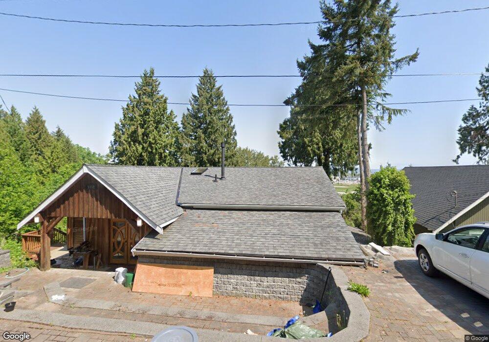
1882 Cliff Rd Point Roberts, WA 98281
Estimated Value: $595,622 - $657,000
2
Beds
3
Baths
1,807
Sq Ft
$340/Sq Ft
Est. Value
About This Home
This home is located at 1882 Cliff Rd, Point Roberts, WA 98281 and is currently estimated at $615,156, approximately $340 per square foot. 1882 Cliff Rd is a home located in Whatcom County with nearby schools including Point Roberts Primary School, Blaine Middle School, and Blaine High School.
Ownership History
Date
Name
Owned For
Owner Type
Purchase Details
Closed on
Aug 24, 2021
Sold by
Fleming Kim and Moat Ralph
Bought by
Orr Robert and Kellogg Anna
Current Estimated Value
Home Financials for this Owner
Home Financials are based on the most recent Mortgage that was taken out on this home.
Original Mortgage
$479,750
Outstanding Balance
$435,584
Interest Rate
2.8%
Mortgage Type
New Conventional
Estimated Equity
$179,572
Purchase Details
Closed on
Jun 16, 2015
Sold by
Meire Cary William
Bought by
Fleming Kim and Moat Ralph
Purchase Details
Closed on
Mar 22, 2004
Sold by
Wolfe Terrence E and Dixon Marlene
Bought by
Meire Cary William
Create a Home Valuation Report for This Property
The Home Valuation Report is an in-depth analysis detailing your home's value as well as a comparison with similar homes in the area
Home Values in the Area
Average Home Value in this Area
Purchase History
| Date | Buyer | Sale Price | Title Company |
|---|---|---|---|
| Orr Robert | $505,000 | Chicago Title Company | |
| Fleming Kim | $162,000 | None Available | |
| Meire Cary William | -- | Whatcom Land Title |
Source: Public Records
Mortgage History
| Date | Status | Borrower | Loan Amount |
|---|---|---|---|
| Open | Orr Robert | $479,750 |
Source: Public Records
Tax History Compared to Growth
Tax History
| Year | Tax Paid | Tax Assessment Tax Assessment Total Assessment is a certain percentage of the fair market value that is determined by local assessors to be the total taxable value of land and additions on the property. | Land | Improvement |
|---|---|---|---|---|
| 2024 | $4,473 | $569,312 | $162,608 | $406,704 |
| 2023 | $4,473 | $554,529 | $147,825 | $406,704 |
| 2022 | $2,750 | $506,419 | $135,000 | $371,419 |
| 2021 | $2,738 | $275,698 | $53,504 | $222,194 |
| 2020 | $2,726 | $255,272 | $49,540 | $205,732 |
| 2019 | $2,527 | $244,863 | $47,520 | $197,343 |
| 2018 | $2,421 | $220,130 | $42,720 | $177,410 |
| 2017 | $2,099 | $210,236 | $40,800 | $169,436 |
| 2016 | $2,111 | $206,114 | $40,000 | $166,114 |
| 2015 | -- | $201,522 | $40,576 | $160,946 |
| 2014 | -- | $210,675 | $42,420 | $168,255 |
| 2013 | -- | $201,301 | $40,740 | $160,561 |
Source: Public Records
Map
Nearby Homes
- 1931 Sanders Ct Unit 11
- 1871 Johnson Rd
- 25 Roosevelt Way
- 0 3 73 Acres Derby Ave
- 1 Mill Rd
- 2 Mill Rd
- 245 Shady Glen Ave
- 125 Park Dr
- 103 Goodman Rd
- 2145 Fir St
- 8 Heather Way
- 17 Lot Massey Way
- 2 Benson Rd
- 1521 Roosevelt Way
- 2138 Benson Rd
- 251 Elizabeth Dr
- 0 6 39 Acres South Beach Rd
- Lot 2 Greenwood Dr
- 168 Tyee Dr
- 1518 #10 Churchill Dr
- 1888 Cliff Rd
- 1894 Cliff Rd
- 65 Calgary Way
- 1898 Cliff Rd
- 1881 Cliff Rd
- 404 Sunset Dr Unit HIGH
- 17 Alberta Way
- 1900 Cliff Rd
- 1873 Roosevelt Way
- 1893 Cliff Rd
- 75 Calgary Way
- 1897 Cliff Rd
- 76 Calgary Way
- 161 Ronald Dr
- 161 Ronald Dr
- 70 Victoria Way
- 1887 Roosevelt Way
- 1856 Cliff Rd
- 51 Alberta Way
- 83 Calgary Way