Estimated Value: $490,000 - $554,000
3
Beds
2
Baths
1,048
Sq Ft
$505/Sq Ft
Est. Value
About This Home
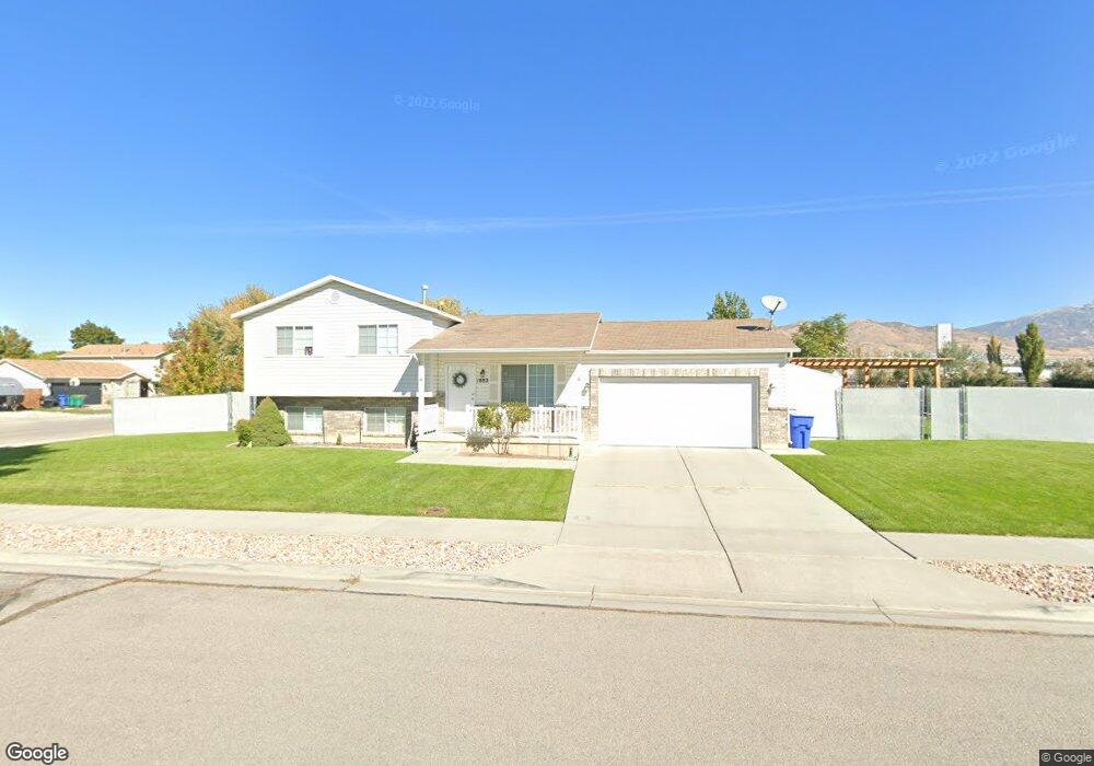
This home is located at 1882 W 1600 N, Lehi, UT 84043 and is currently estimated at $529,668, approximately $505 per square foot. 1882 W 1600 N is a home located in Utah County with nearby schools including North Point Elementary School, Willowcreek Middle School, and Lehi High School.
Ownership History
Date
Name
Owned For
Owner Type
Purchase Details
Closed on
Mar 29, 2004
Sold by
Bean Robert and Bean Michelle
Bought by
Bean Robert L and Bean Michelle W
Current Estimated Value
Home Financials for this Owner
Home Financials are based on the most recent Mortgage that was taken out on this home.
Original Mortgage
$141,000
Outstanding Balance
$53,922
Interest Rate
3%
Mortgage Type
New Conventional
Estimated Equity
$475,746
Purchase Details
Closed on
Oct 24, 2000
Sold by
Bean Robert L
Bought by
Bean Robert L and Bean Michelle W
Home Financials for this Owner
Home Financials are based on the most recent Mortgage that was taken out on this home.
Original Mortgage
$17,000
Interest Rate
7.89%
Purchase Details
Closed on
Jan 28, 1999
Sold by
Salisbury Development Lc
Bought by
Bean Robert L
Home Financials for this Owner
Home Financials are based on the most recent Mortgage that was taken out on this home.
Original Mortgage
$123,006
Interest Rate
6.63%
Mortgage Type
VA
Create a Home Valuation Report for This Property
The Home Valuation Report is an in-depth analysis detailing your home's value as well as a comparison with similar homes in the area
Home Values in the Area
Average Home Value in this Area
Purchase History
| Date | Buyer | Sale Price | Title Company |
|---|---|---|---|
| Bean Robert L | -- | Mountain West Title Co | |
| Bean Robert | -- | Mountain West Title Co | |
| Bean Robert L | -- | Mountain West Title Co | |
| Bean Robert L | -- | Provo Land Title Company |
Source: Public Records
Mortgage History
| Date | Status | Borrower | Loan Amount |
|---|---|---|---|
| Open | Bean Robert | $141,000 | |
| Closed | Bean Robert L | $17,000 | |
| Closed | Bean Robert L | $123,006 |
Source: Public Records
Tax History Compared to Growth
Tax History
| Year | Tax Paid | Tax Assessment Tax Assessment Total Assessment is a certain percentage of the fair market value that is determined by local assessors to be the total taxable value of land and additions on the property. | Land | Improvement |
|---|---|---|---|---|
| 2025 | $1,984 | $259,325 | $207,800 | $263,700 |
| 2024 | $1,820 | $232,155 | $0 | $0 |
| 2023 | $24 | $231,220 | $0 | $0 |
| 2022 | $24 | $250,525 | $0 | $0 |
| 2021 | $1,797 | $334,700 | $120,200 | $214,500 |
| 2020 | $1,497 | $311,800 | $111,300 | $200,500 |
| 2019 | $1,497 | $286,400 | $111,300 | $175,100 |
| 2018 | $1,407 | $254,600 | $99,300 | $155,300 |
| 2017 | $1,361 | $130,900 | $0 | $0 |
| 2016 | -- | $117,975 | $0 | $0 |
| 2015 | $1,301 | $110,165 | $0 | $0 |
| 2014 | -- | $99,110 | $0 | $0 |
Source: Public Records
Map
Nearby Homes
- 1648 N 1900 W
- 1542 N 1900 W
- 1908 N 2230 W
- 1896 N 2230 W
- 1870 N 2230 W
- 1970 N 2090 St W
- 1659 W Boxwood Dr Unit 109
- 1627 W Boxwood Dr Unit 110
- Huntington Plan at Pioneer Meadows
- Silver Lake Plan at Pioneer Meadows
- Summit Plan at Pioneer Meadows
- Palisade Plan at Pioneer Meadows
- 1332 W 1500 N
- 2012 N 2040 W
- 1969 N 2040 St W
- 1968 N 2040 W
- 2013 N 2040 W
- 1990 N 2040 W
- 1898 W Pointe Meadow Loop
- 5312 N Springview Ct Unit 106