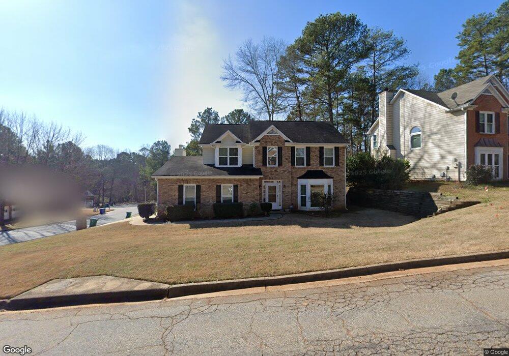
1883 Fairpointe Trace Stone Mountain, GA 30088
Estimated Value: $287,569 - $337,000
4
Beds
3
Baths
2,341
Sq Ft
$129/Sq Ft
Est. Value
About This Home
This home is located at 1883 Fairpointe Trace, Stone Mountain, GA 30088 and is currently estimated at $302,392, approximately $129 per square foot. 1883 Fairpointe Trace is a home located in DeKalb County with nearby schools including Woodridge Elementary School, Miller Grove Middle School, and Miller Grove High School.
Ownership History
Date
Name
Owned For
Owner Type
Purchase Details
Closed on
Sep 3, 2010
Sold by
Atlanta Nbrhd Dev Ptshp Inc
Bought by
Sanders Arlene
Current Estimated Value
Home Financials for this Owner
Home Financials are based on the most recent Mortgage that was taken out on this home.
Original Mortgage
$106,340
Interest Rate
4.75%
Mortgage Type
FHA
Purchase Details
Closed on
Feb 2, 2010
Sold by
Sutton Jeffrey
Bought by
Brand Banking Co
Purchase Details
Closed on
Sep 2, 2008
Sold by
Sutton Jeffrey
Bought by
Brand Mtg Grp Llc
Home Financials for this Owner
Home Financials are based on the most recent Mortgage that was taken out on this home.
Original Mortgage
$166,500
Interest Rate
6.61%
Mortgage Type
New Conventional
Create a Home Valuation Report for This Property
The Home Valuation Report is an in-depth analysis detailing your home's value as well as a comparison with similar homes in the area
Home Values in the Area
Average Home Value in this Area
Purchase History
| Date | Buyer | Sale Price | Title Company |
|---|---|---|---|
| Sanders Arlene | $125,000 | -- | |
| Brand Banking Co | $165,336 | -- | |
| Brand Mtg Grp Llc | $165,336 | -- | |
| Sutton Jeffrey | $185,000 | -- |
Source: Public Records
Mortgage History
| Date | Status | Borrower | Loan Amount |
|---|---|---|---|
| Previous Owner | Sanders Arlene | $106,340 | |
| Previous Owner | Sutton Jeffrey | $166,500 |
Source: Public Records
Tax History
| Year | Tax Paid | Tax Assessment Tax Assessment Total Assessment is a certain percentage of the fair market value that is determined by local assessors to be the total taxable value of land and additions on the property. | Land | Improvement |
|---|---|---|---|---|
| 2025 | $3,268 | $111,280 | $13,354 | $97,926 |
| 2024 | $3,377 | $112,080 | $14,000 | $98,080 |
| 2023 | $3,377 | $120,560 | $14,000 | $106,560 |
Source: Public Records
Map
Nearby Homes
- 4945 Penscot Way
- 1966 S Hidden Hills Pkwy
- 1955 Wynhurst Crossing Unit 16B
- 2020 S Hidden Hills Pkwy
- 5035 Villas Terrace
- 4626 Biffle Rd
- 4889 Wedgewood Way
- 2631 Young Rd
- 4933 Clubgreen Summit
- 2062 Crossing Rd
- 2064 Crossing Rd
- 2066 Crossing Rd
- 2068 Crossing Rd
- 5013 Oakwood Rd
- 5007 Oakwood Rd
- 5015 Oakwood Rd
- 5011 Oakwood Rd
- 5009 Oakwood Rd
- 2070 Crossing Rd
- 2072 Crossing Rd
- 5009 Greenwyck Path
- 1893 Fairpointe Trace Unit 15
- 1869 Fairpointe Trace
- 1882 Fairpointe Trace Unit 15
- 1888 Fairpointe Trace
- 1874 Fairpointe Trace Unit 15
- 1896 Fairpointe Trace
- 1857 Fairpointe Trace
- 4988 Wynhurst Way
- 5007 Penscot Way Unit 16C
- 1849 Fairpointe Trace Unit 15
- 1900 Fairpointe Trace
- 1866 Fairpointe Trace Unit 15
- 5003 Penscot Way
- 4989 Wynhurst Way
- 4982 Wynhurst Way
- 5006 Penscot Way
- 1862 Fairpointe Trace
- 4983 Wynhurst Way Unit 16A
- 1845 Fairpointe Trace Unit 15
Your Personal Tour Guide
Ask me questions while you tour the home.