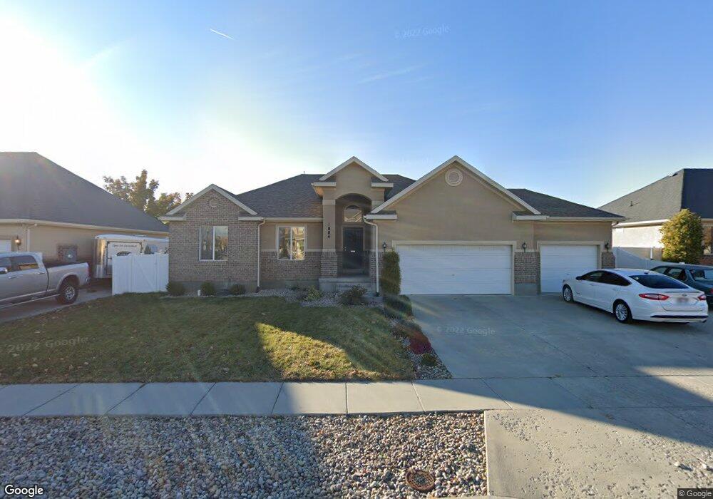
1884 Bluff Ridge Dr Syracuse, UT 84075
Estimated Value: $600,000 - $639,000
4
Beds
4
Baths
3,379
Sq Ft
$184/Sq Ft
Est. Value
About This Home
This home is located at 1884 Bluff Ridge Dr, Syracuse, UT 84075 and is currently estimated at $622,868, approximately $184 per square foot. 1884 Bluff Ridge Dr is a home located in Davis County with nearby schools including Bluff Ridge Elementary, Legacy Junior High School, and Clearfield High School.
Ownership History
Date
Name
Owned For
Owner Type
Purchase Details
Closed on
Jun 12, 2006
Sold by
Richmond American Homes Of Utah Inc
Bought by
Hunt Kevin and Hunt Lissette
Current Estimated Value
Create a Home Valuation Report for This Property
The Home Valuation Report is an in-depth analysis detailing your home's value as well as a comparison with similar homes in the area
Home Values in the Area
Average Home Value in this Area
Purchase History
| Date | Buyer | Sale Price | Title Company |
|---|---|---|---|
| Hunt Kevin | -- | First American Title |
Source: Public Records
Tax History Compared to Growth
Tax History
| Year | Tax Paid | Tax Assessment Tax Assessment Total Assessment is a certain percentage of the fair market value that is determined by local assessors to be the total taxable value of land and additions on the property. | Land | Improvement |
|---|---|---|---|---|
| 2025 | $3,438 | $331,650 | $119,915 | $211,735 |
| 2024 | $3,278 | $318,449 | $94,582 | $223,867 |
| 2023 | $3,158 | $307,450 | $72,625 | $234,824 |
| 2022 | $3,384 | $597,000 | $139,330 | $457,670 |
| 2021 | $2,916 | $438,000 | $112,730 | $325,270 |
| 2020 | $359 | $398,000 | $100,492 | $297,508 |
| 2019 | $311 | $384,000 | $95,433 | $288,567 |
| 2018 | $180 | $357,000 | $93,659 | $263,341 |
| 2016 | $217 | $168,190 | $36,051 | $132,139 |
| 2015 | $1,999 | $142,285 | $36,051 | $106,234 |
| 2014 | $1,882 | $136,497 | $36,051 | $100,446 |
| 2013 | -- | $141,798 | $32,907 | $108,891 |
Source: Public Records
Map
Nearby Homes
- 877 W 1920 S Unit C
- 891 W 1840 S Unit A
- 891 W 1920 S Unit C
- 929 W 1920 S Unit A
- 1913 S 525 W
- 992 W 1910 S
- 936 W 2225 S
- 1153 W 1875 S
- 1079 W 2050 S
- Everglade Plan at Wilcox Farms
- Echo Plan at Wilcox Farms
- Granite Plan at Wilcox Farms
- 1553 S 900 W Unit 139
- 1622 S 1000 W
- 904 W 2300 S
- 1142 W 2050 S
- 1148 W 2050 S
- 2232 S 1000 W
- Stetson Plan at Wilcox Farms
- Caldwell Plan at Wilcox Farms
- 1870 Bluff Ridge Dr
- 1898 Bluff Ridge Dr
- 1887 Bluff Ridge Dr
- 1873 S 830 W Unit B
- 1873 Bluff Ridge Dr
- 1856 Bluff Ridge Dr
- 1914 Bluff Ridge Dr
- 1842 Bluff Ridge Dr
- 731 W 1900 S
- 1897 S 830 W Unit D
- 718 W 1900 S
- 1849 S 830 W Unit B
- 1849 S 830 W Unit A
- 717 W 1850 S
- 1919 S 830 W Unit D
- 1919 S 830 W Unit D
- 733 W 1850 S
- 732 W 1850 S
- 715 W 1900 S
- 1930 Bluff Ridge Dr