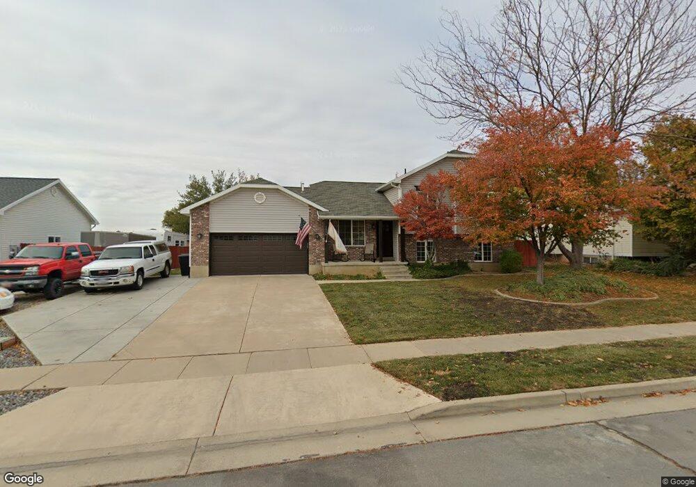
1886 Dahl Ln Syracuse, UT 84075
Estimated Value: $475,000 - $588,000
5
Beds
2
Baths
2,200
Sq Ft
$235/Sq Ft
Est. Value
About This Home
This home is located at 1886 Dahl Ln, Syracuse, UT 84075 and is currently estimated at $517,298, approximately $235 per square foot. 1886 Dahl Ln is a home located in Davis County with nearby schools including Cook School, Syracuse Junior High School, and Syracuse High School.
Ownership History
Date
Name
Owned For
Owner Type
Purchase Details
Closed on
Jun 28, 2018
Sold by
Green Landon G and Green Jihye K
Bought by
Hassell Robert A and Hassell Brigitte D
Current Estimated Value
Home Financials for this Owner
Home Financials are based on the most recent Mortgage that was taken out on this home.
Original Mortgage
$281,100
Outstanding Balance
$243,104
Interest Rate
4.5%
Mortgage Type
VA
Estimated Equity
$274,194
Purchase Details
Closed on
Mar 14, 2014
Sold by
Shupe Robert and Shupe Marleigh
Bought by
Shupe Robert B and Shupe Marleigh
Home Financials for this Owner
Home Financials are based on the most recent Mortgage that was taken out on this home.
Original Mortgage
$196,200
Interest Rate
3.29%
Mortgage Type
New Conventional
Purchase Details
Closed on
Feb 27, 2008
Sold by
Shupe Robert and Shupe Marleigh
Bought by
Shupe Robert and Shupe Marleigh
Home Financials for this Owner
Home Financials are based on the most recent Mortgage that was taken out on this home.
Original Mortgage
$210,600
Interest Rate
5.64%
Mortgage Type
New Conventional
Purchase Details
Closed on
Aug 22, 2007
Sold by
Lowe Albert F
Bought by
Shupe Robert and Coleman Marleigh
Home Financials for this Owner
Home Financials are based on the most recent Mortgage that was taken out on this home.
Original Mortgage
$51,600
Interest Rate
6.73%
Mortgage Type
Unknown
Purchase Details
Closed on
Apr 3, 2003
Sold by
Mcclure Mark A and Mcclure Karen E
Bought by
Lowe Albert F
Home Financials for this Owner
Home Financials are based on the most recent Mortgage that was taken out on this home.
Original Mortgage
$138,720
Interest Rate
5.54%
Mortgage Type
VA
Purchase Details
Closed on
Dec 27, 1996
Sold by
Watt Residential Partners
Bought by
Mcclure Mark A and Mcclure Karen E
Home Financials for this Owner
Home Financials are based on the most recent Mortgage that was taken out on this home.
Original Mortgage
$129,651
Interest Rate
7.59%
Mortgage Type
VA
Create a Home Valuation Report for This Property
The Home Valuation Report is an in-depth analysis detailing your home's value as well as a comparison with similar homes in the area
Home Values in the Area
Average Home Value in this Area
Purchase History
| Date | Buyer | Sale Price | Title Company |
|---|---|---|---|
| Hassell Robert A | -- | First American Title | |
| Shupe Robert B | -- | Hickman Land Title Co | |
| Shupe Robert | -- | Lincoln Title Ins Agency | |
| Shupe Robert | -- | First American Title | |
| Lowe Albert F | -- | First American Title Co | |
| Mcclure Mark A | -- | First American Title Co |
Source: Public Records
Mortgage History
| Date | Status | Borrower | Loan Amount |
|---|---|---|---|
| Open | Hassell Robert A | $281,100 | |
| Previous Owner | Shupe Robert B | $196,200 | |
| Previous Owner | Shupe Robert | $210,600 | |
| Previous Owner | Shupe Robert | $51,600 | |
| Previous Owner | Shupe Robert | $154,800 | |
| Previous Owner | Lowe Albert F | $138,720 | |
| Previous Owner | Mcclure Mark A | $129,651 |
Source: Public Records
Tax History Compared to Growth
Tax History
| Year | Tax Paid | Tax Assessment Tax Assessment Total Assessment is a certain percentage of the fair market value that is determined by local assessors to be the total taxable value of land and additions on the property. | Land | Improvement |
|---|---|---|---|---|
| 2025 | $1,581 | $256,850 | $123,707 | $133,143 |
| 2024 | $1,513 | $248,050 | $101,129 | $146,921 |
| 2023 | $1,377 | $418,000 | $140,978 | $277,022 |
| 2022 | $1,960 | $246,950 | $81,315 | $165,635 |
| 2021 | $1,623 | $344,000 | $120,031 | $223,969 |
| 2020 | $1,363 | $297,000 | $105,154 | $191,846 |
| 2019 | $1,303 | $284,000 | $102,057 | $181,943 |
| 2018 | $1,684 | $240,000 | $98,955 | $141,045 |
| 2016 | $1,518 | $113,465 | $38,008 | $75,457 |
| 2015 | $1,458 | $103,730 | $38,008 | $65,722 |
| 2014 | $1,391 | $100,905 | $38,008 | $62,897 |
| 2013 | -- | $96,787 | $32,054 | $64,733 |
Source: Public Records
Map
Nearby Homes