
Seller's Agent in 2025
Yannis Arbis
First Western Properties
(847) 858-6569
1 in this area
13 Total Sales
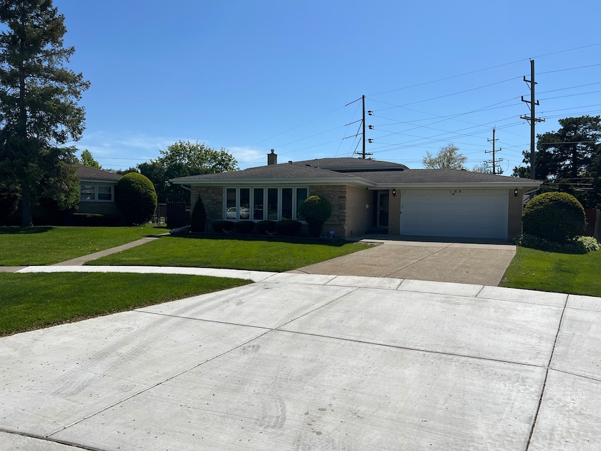


Welcome to your future home, tucked away in a quiet cul-de-sac and move-in ready with fresh, neutral decor throughout. This spacious split-level features an attached two-car garage, providing sheltered access in all weather. Step out back to a large concrete patio-perfect for entertaining-and a fully fenced yard where kids and pets can play freely. Inside, the open-concept layout centers around a modern kitchen with a large island that flows into the living and dining areas. Upgrades include porcelain tile, sleek cabinetry, stone countertops, and stainless steel appliances. Remodeled bathrooms offer custom tile showers and contemporary finishes. Light-stained hardwood floors run through the living and dining rooms, staircase, hallway, and all bedrooms, adding warmth and continuity. Additional highlights include updated mechanical systems, a concrete crawl space for extra storage, and exterior improvements such as a newer asphalt roof, vinyl windows and siding, and aluminum soffits, fascia, and gutters. Ideally located near elementary, middle, and high schools, with quick access to Highways 90, 290, and 53, Metra, Woodfield Mall, and major shopping destinations.
Last Agent to Sell the Property
First Western Properties License #475142723 Listed on: 07/13/2025
| Date | Type | Sale Price | Title Company |
|---|---|---|---|
| Warranty Deed | $465,500 | None Listed On Document | |
| Joint Tenancy Deed | $120,666 | -- |
| Date | Status | Loan Amount | Loan Type |
|---|---|---|---|
| Previous Owner | $40,000 | No Value Available |
| Date | Event | Price | List to Sale | Price per Sq Ft |
|---|---|---|---|---|
| 09/23/2025 09/23/25 | Sold | $465,101 | -0.8% | $255 / Sq Ft |
| 09/01/2025 09/01/25 | Pending | -- | -- | -- |
| 08/29/2025 08/29/25 | Price Changed | $469,000 | -6.0% | $257 / Sq Ft |
| 07/13/2025 07/13/25 | For Sale | $499,000 | -- | $274 / Sq Ft |
| Year | Tax Paid | Tax Assessment Tax Assessment Total Assessment is a certain percentage of the fair market value that is determined by local assessors to be the total taxable value of land and additions on the property. | Land | Improvement |
|---|---|---|---|---|
| 2025 | $3,991 | $38,000 | $9,079 | $28,921 |
| 2024 | $3,991 | $34,000 | $7,782 | $26,218 |
| 2023 | $3,936 | $34,000 | $7,782 | $26,218 |
| 2022 | $3,936 | $34,000 | $7,782 | $26,218 |
| 2021 | $4,211 | $21,816 | $5,188 | $16,628 |
| 2020 | $4,069 | $21,816 | $5,188 | $16,628 |
| 2019 | $4,092 | $24,241 | $5,188 | $19,053 |
| 2018 | $4,442 | $22,765 | $4,323 | $18,442 |
| 2017 | $4,394 | $22,765 | $4,323 | $18,442 |
| 2016 | $5,288 | $24,766 | $4,323 | $20,443 |
| 2015 | $4,565 | $21,063 | $3,891 | $17,172 |
| 2014 | $5,201 | $23,491 | $3,891 | $19,600 |
| 2013 | $5,063 | $23,491 | $3,891 | $19,600 |
Seller's Agent in 2025
Yannis Arbis
First Western Properties
(847) 858-6569
1 in this area
13 Total Sales
Buyer's Agent in 2025
Rajendra Shah
Century 21 Circle
(847) 809-5730
4 in this area
68 Total Sales
Source: Midwest Real Estate Data (MRED)
MLS Number: 12418692
APN: 08-13-408-056-0000
Disclaimer: Certain information contained herein is derived from information provided by parties other than Homes.com. All information provided is deemed reliable, but is not guaranteed to be accurate and should be independently verified.
![]() Based on information submitted to the MLS GRID. All data is obtained from various sources and may not have been verified by broker or MLS GRID. Supplied Open House Information is subject to change without notice. All information should be independently reviewed and verified for accuracy. Properties may or may not be listed by the office/agent presenting the information. Some IDX listings have been excluded from this website.
Based on information submitted to the MLS GRID. All data is obtained from various sources and may not have been verified by broker or MLS GRID. Supplied Open House Information is subject to change without notice. All information should be independently reviewed and verified for accuracy. Properties may or may not be listed by the office/agent presenting the information. Some IDX listings have been excluded from this website.
Based on information submitted to the MLS GRID
Ask me questions while you tour the home.