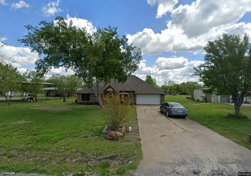
189 Choctaw Est Cir Sherman, TX 75092
Estimated Value: $400,000 - $494,000
3
Beds
2
Baths
2,125
Sq Ft
$205/Sq Ft
Est. Value
About This Home
This home is located at 189 Choctaw Est Cir, Sherman, TX 75092 and is currently estimated at $434,804, approximately $204 per square foot. 189 Choctaw Est Cir is a home located in Grayson County with nearby schools including S&S Consolidated Elementary School, S&S Consolidated Middle School, and S. & S. Cons H.S..
Ownership History
Date
Name
Owned For
Owner Type
Purchase Details
Closed on
Nov 8, 2019
Sold by
Brookshire Carl W and Brookshire Sharon K
Bought by
Hodge Glen
Current Estimated Value
Purchase Details
Closed on
Nov 16, 2011
Sold by
Marr Dennis M and Marr Rose M
Bought by
Brookshire Carl W and Brookshire Sharon K
Home Financials for this Owner
Home Financials are based on the most recent Mortgage that was taken out on this home.
Original Mortgage
$109,000
Interest Rate
3.32%
Mortgage Type
New Conventional
Create a Home Valuation Report for This Property
The Home Valuation Report is an in-depth analysis detailing your home's value as well as a comparison with similar homes in the area
Home Values in the Area
Average Home Value in this Area
Purchase History
| Date | Buyer | Sale Price | Title Company |
|---|---|---|---|
| Hodge Glen | -- | Red River Title Co | |
| Brookshire Carl W | -- | Red River Title Co |
Source: Public Records
Mortgage History
| Date | Status | Borrower | Loan Amount |
|---|---|---|---|
| Previous Owner | Brookshire Carl W | $109,000 |
Source: Public Records
Tax History Compared to Growth
Tax History
| Year | Tax Paid | Tax Assessment Tax Assessment Total Assessment is a certain percentage of the fair market value that is determined by local assessors to be the total taxable value of land and additions on the property. | Land | Improvement |
|---|---|---|---|---|
| 2025 | $3,064 | $331,766 | -- | -- |
| 2024 | $4,503 | $301,605 | $0 | $0 |
| 2023 | $2,801 | $274,186 | $0 | $0 |
| 2022 | $4,192 | $249,260 | $0 | $0 |
| 2021 | $4,310 | $239,880 | $32,000 | $207,880 |
| 2020 | $4,041 | $206,000 | $32,000 | $174,000 |
| 2019 | $3,668 | $214,316 | $32,000 | $182,316 |
| 2018 | $3,054 | $159,925 | $32,000 | $127,925 |
| 2017 | $2,796 | $146,002 | $32,000 | $114,002 |
| 2016 | $2,542 | $129,591 | $27,000 | $102,591 |
| 2015 | $2,214 | $135,011 | $21,000 | $114,011 |
| 2014 | $2,327 | $134,246 | $21,000 | $113,246 |
Source: Public Records
Map
Nearby Homes
- 6514 Joyce Ln
- 1171 Rockport Rd
- 586 Pleasant Home Rd
- 2615 Rolling Hills Dr
- 3356 Old Dorchester Rd
- 00 Primrose Ln
- 1401 Cimmaron Trail
- 1404 Tejas Dr
- 1426 S Raven Dr
- 1407 Swan Ridge Dr
- 4501 Hawk Ln
- 4507 Falcon Dr
- 6935 S Farm To Market Road 1417
- 1415 Mallard Dr
- 2134 Peggeys Cove
- 1412 Ascot Ave
- 3508 Ballam St
- 10.96 Acres Wible Rd
- 750 Wible Rd
- TBD Wible Rd
- 157 Choctaw Est Cir
- 200 Choctaw Est Cir
- 255 Choctaw Est Cir
- 256 Choctaw Est Cir
- 565 Choctaw Est Cir
- 645 Choctaw Estate Cir
- 112 Choctaw Est Cir
- 351 Choctaw Est Cir
- 351 Choctaw Est Cir
- 517 Choctaw Est Cir
- 17 Lot Choctaw Estates Cir
- 663 Choctaw Est Cir
- 284 Choctaw Est Cir
- 284 Choctaw Est Cir Unit LAND
- 284 Choctaw Est Cir
- 82 Choctaw Est Cir
- 320 Choctaw Est Cir
- 198 Rockport Rd
- 176 Rockport Rd
- 220 Rockport Rd