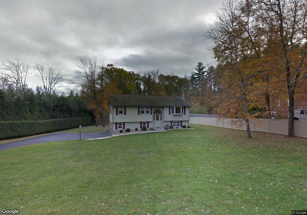
189 Laurel St West Boylston, MA 01583
Estimated Value: $435,000 - $607,000
3
Beds
2
Baths
1,138
Sq Ft
$473/Sq Ft
Est. Value
About This Home
This home is located at 189 Laurel St, West Boylston, MA 01583 and is currently estimated at $537,794, approximately $472 per square foot. 189 Laurel St is a home located in Worcester County with nearby schools including Major Edwards Elementary School and West Boylston Junior/Senior High School.
Ownership History
Date
Name
Owned For
Owner Type
Purchase Details
Closed on
Jul 30, 2015
Sold by
Kennedy Wendi L
Bought by
Wendi L Kennedy T
Current Estimated Value
Purchase Details
Closed on
Sep 17, 2013
Sold by
Kennedy Thomas F and Kennedy Wendi L
Bought by
Kennedy Wendi L
Purchase Details
Closed on
Mar 31, 1998
Sold by
Roehrig Donna S
Bought by
Kennedy Thomas F and Kennedy Wendi L
Home Financials for this Owner
Home Financials are based on the most recent Mortgage that was taken out on this home.
Original Mortgage
$80,000
Interest Rate
6.96%
Mortgage Type
Purchase Money Mortgage
Create a Home Valuation Report for This Property
The Home Valuation Report is an in-depth analysis detailing your home's value as well as a comparison with similar homes in the area
Home Values in the Area
Average Home Value in this Area
Purchase History
| Date | Buyer | Sale Price | Title Company |
|---|---|---|---|
| Wendi L Kennedy T | -- | -- | |
| Kennedy Wendi L | -- | -- | |
| Kennedy Thomas F | $100,000 | -- |
Source: Public Records
Mortgage History
| Date | Status | Borrower | Loan Amount |
|---|---|---|---|
| Previous Owner | Kennedy Thomas F | $80,000 |
Source: Public Records
Tax History Compared to Growth
Tax History
| Year | Tax Paid | Tax Assessment Tax Assessment Total Assessment is a certain percentage of the fair market value that is determined by local assessors to be the total taxable value of land and additions on the property. | Land | Improvement |
|---|---|---|---|---|
| 2025 | $73 | $524,100 | $127,800 | $396,300 |
| 2024 | $6,849 | $463,400 | $128,700 | $334,700 |
| 2023 | $6,520 | $418,500 | $126,600 | $291,900 |
| 2022 | $6,379 | $360,800 | $126,600 | $234,200 |
| 2021 | $6,073 | $329,000 | $108,000 | $221,000 |
| 2020 | $6,024 | $324,200 | $108,000 | $216,200 |
| 2019 | $5,889 | $312,400 | $108,000 | $204,400 |
| 2018 | $5,438 | $290,500 | $108,000 | $182,500 |
| 2017 | $5,057 | $269,000 | $108,000 | $161,000 |
| 2016 | $4,585 | $248,500 | $100,500 | $148,000 |
| 2015 | $4,453 | $242,800 | $99,700 | $143,100 |
Source: Public Records
Map
Nearby Homes
- 287 Laurel St
- 16 N Main St
- 0 North St
- 26 Townsend Dr
- Lot 1 Manning St
- 20 Winthrop St
- 136 Sterling St Unit A3
- 0 Boutelle Rd
- 156 Prospect St
- 61 Boutelle Rd
- 223 Worcester Rd
- 2 Lakeview Ave
- 751 Mason Rd
- 18 Laurel Ave
- 21 Myrtle Ave
- 152 Worcester St Unit 8
- 54 Maple St
- 62 Maple St
- 47 Preservation Ln
- 4 Jewett Rd Unit B