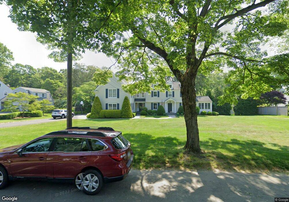
189 N Cedar Rd Fairfield, CT 06824
University NeighborhoodEstimated Value: $1,929,000 - $2,259,000
5
Beds
5
Baths
4,148
Sq Ft
$490/Sq Ft
Est. Value
About This Home
This home is located at 189 N Cedar Rd, Fairfield, CT 06824 and is currently estimated at $2,030,662, approximately $489 per square foot. 189 N Cedar Rd is a home located in Fairfield County with nearby schools including Dwight Elementary School, Roger Ludlowe Middle School, and Fairfield Ludlowe High School.
Ownership History
Date
Name
Owned For
Owner Type
Purchase Details
Closed on
Jun 30, 2009
Sold by
Kanaga Amanda P
Bought by
Kelleher 3Rd William J and Kelleher Margaret M
Current Estimated Value
Purchase Details
Closed on
Jul 16, 2004
Sold by
Keane Teale F
Bought by
Kanaga Amanda P
Create a Home Valuation Report for This Property
The Home Valuation Report is an in-depth analysis detailing your home's value as well as a comparison with similar homes in the area
Home Values in the Area
Average Home Value in this Area
Purchase History
| Date | Buyer | Sale Price | Title Company |
|---|---|---|---|
| Kelleher 3Rd William J | $1,350,000 | -- | |
| Kelleher 3Rd William J | $1,350,000 | -- | |
| Kanaga Amanda P | $919,500 | -- | |
| Kanaga Amanda P | $919,500 | -- |
Source: Public Records
Mortgage History
| Date | Status | Borrower | Loan Amount |
|---|---|---|---|
| Open | Kanaga Amanda P | $495,000 | |
| Closed | Kanaga Amanda P | $200,000 |
Source: Public Records
Tax History Compared to Growth
Tax History
| Year | Tax Paid | Tax Assessment Tax Assessment Total Assessment is a certain percentage of the fair market value that is determined by local assessors to be the total taxable value of land and additions on the property. | Land | Improvement |
|---|---|---|---|---|
| 2025 | $22,059 | $777,000 | $478,870 | $298,130 |
| 2024 | $21,678 | $777,000 | $478,870 | $298,130 |
| 2023 | $21,375 | $777,000 | $478,870 | $298,130 |
| 2022 | $21,165 | $777,000 | $478,870 | $298,130 |
| 2021 | $20,963 | $777,000 | $478,870 | $298,130 |
| 2020 | $23,792 | $888,090 | $474,110 | $413,980 |
| 2019 | $23,792 | $888,090 | $474,110 | $413,980 |
| 2018 | $23,410 | $888,090 | $474,110 | $413,980 |
| 2017 | $22,699 | $879,130 | $474,110 | $405,020 |
| 2016 | $22,374 | $879,130 | $474,110 | $405,020 |
| 2015 | $21,745 | $877,170 | $497,000 | $380,170 |
| 2014 | $21,403 | $877,170 | $497,000 | $380,170 |
Source: Public Records
Map
Nearby Homes
- 254 Sherwood Farm Rd
- 11 Twin Brooks Ln
- 160 Hunter Rd
- 232 Pell Meadow Dr
- 1135 Mill Hill Rd
- 175 Alma Dr
- 1477 Mill Plain Rd
- 83 Pell Meadow Dr
- 2683 Bronson Rd
- 214 Henry St
- 93 Millspaugh Dr
- 46 Middlebrook Dr
- 52 Glover St
- 245 Taunton Rd
- 172 Sycamore Ln
- 276 Carroll Rd
- 647 Bronson Rd
- 688 Hulls Farm Rd
- 844 Mill Hill Terrace
- 83 Mailands Rd
- 217 N Cedar Rd
- 208 N Cedar Rd
- 245 N Cedar Rd
- 245 N Cedar Rd
- 159 N Cedar Rd
- 172 N Cedar Rd
- 172 N Cedar Rd
- 275 N Cedar Rd
- 240 N Cedar Rd
- 272 N Cedar Rd
- 130 N Cedar Rd
- 90 N Cedar Rd
- 310 N Cedar Rd
- 305 N Cedar Rd
- 1728 Bronson Rd
- 601 Hill Farm Rd
- 1780 Bronson Rd
- 58 N Cedar Rd
- 343 N Cedar Rd
- 1660 Bronson Rd