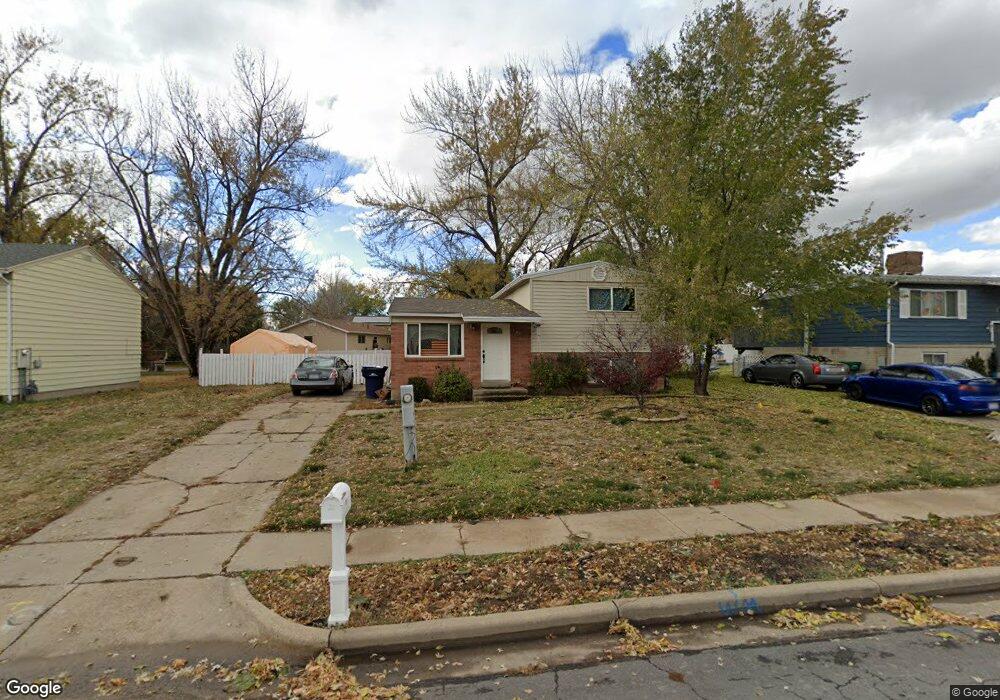
189 N Cook Dr Layton, UT 84041
Estimated Value: $378,000 - $420,000
3
Beds
2
Baths
1,180
Sq Ft
$345/Sq Ft
Est. Value
About This Home
This home is located at 189 N Cook Dr, Layton, UT 84041 and is currently estimated at $407,228, approximately $345 per square foot. 189 N Cook Dr is a home located in Davis County with nearby schools including Layton Elementary School, Fairfield Junior High School, and Layton High School.
Ownership History
Date
Name
Owned For
Owner Type
Purchase Details
Closed on
Apr 6, 2022
Sold by
Opendoor Property Trust
Bought by
Williamson Christopher A and Williamson Mary J
Current Estimated Value
Home Financials for this Owner
Home Financials are based on the most recent Mortgage that was taken out on this home.
Original Mortgage
$353,000
Interest Rate
5.81%
Mortgage Type
VA
Purchase Details
Closed on
Nov 22, 2021
Sold by
Johnson Britney
Bought by
Opendoor Property Trust I
Purchase Details
Closed on
Oct 4, 2013
Sold by
Zetino Manuel
Bought by
Jpmorgan Chase Bank Na
Purchase Details
Closed on
Jul 31, 2006
Sold by
Webb Thomas F and Webb Nancy E
Bought by
Zetino Manuel
Create a Home Valuation Report for This Property
The Home Valuation Report is an in-depth analysis detailing your home's value as well as a comparison with similar homes in the area
Home Values in the Area
Average Home Value in this Area
Purchase History
| Date | Buyer | Sale Price | Title Company |
|---|---|---|---|
| Williamson Christopher A | -- | Cottonwood Title | |
| Opendoor Property Trust I | -- | Cottonwood Title | |
| Opendoor Property Trust | -- | Cottonwood Title | |
| Jpmorgan Chase Bank Na | $97,750 | Title Insurance Age | |
| Zetino Manuel | -- | Equity Title Ins Agency Inc |
Source: Public Records
Mortgage History
| Date | Status | Borrower | Loan Amount |
|---|---|---|---|
| Previous Owner | Williamson Christopher A | $353,000 |
Source: Public Records
Tax History Compared to Growth
Tax History
| Year | Tax Paid | Tax Assessment Tax Assessment Total Assessment is a certain percentage of the fair market value that is determined by local assessors to be the total taxable value of land and additions on the property. | Land | Improvement |
|---|---|---|---|---|
| 2025 | -- | $200,200 | $107,584 | $92,616 |
| 2024 | -- | $197,450 | $119,689 | $77,761 |
| 2023 | -- | $339,000 | $117,073 | $221,927 |
| 2022 | $1,590 | $312,000 | $134,788 | $177,212 |
| 2021 | $1,590 | $240,000 | $111,232 | $128,768 |
| 2020 | $1,429 | $207,000 | $93,301 | $113,699 |
| 2019 | $1,389 | $197,000 | $96,582 | $100,418 |
| 2018 | $1,243 | $177,000 | $84,614 | $92,386 |
| 2016 | $1,034 | $75,955 | $32,811 | $43,144 |
| 2015 | $935 | $65,230 | $32,811 | $32,419 |
| 2014 | $883 | $62,959 | $32,811 | $30,148 |
| 2013 | -- | $68,616 | $18,612 | $50,004 |
Source: Public Records
Map
Nearby Homes
- 485 W 100 N
- 356 W 25 N
- 750 W Gentile St
- 355 W Gentile St
- 6 Grover St
- 65 Ronald Ave
- 526 King St Unit 2
- 933 W Gentile St
- 267 S Melody St
- 480 Spurlock St
- 296 S 950 W
- 441 Church St
- 362 S 950 W
- 142 Green Dr
- 562 S 850 W
- 1677 N 1600 W Unit 134
- 298 Amber Ln
- 316 Amber Ln
- Browning Plan at Amber Fields
- Rhapsody Plan at Amber Fields