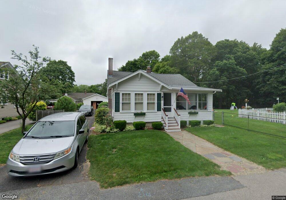
189 Union St Mansfield, MA 02048
Estimated Value: $560,473 - $622,000
2
Beds
1
Bath
1,555
Sq Ft
$378/Sq Ft
Est. Value
About This Home
This home is located at 189 Union St, Mansfield, MA 02048 and is currently estimated at $587,618, approximately $377 per square foot. 189 Union St is a home located in Bristol County with nearby schools including Everett W. Robinson Elementary School, Jordan/Jackson Elementary School, and Harold L. Qualters Middle School.
Ownership History
Date
Name
Owned For
Owner Type
Purchase Details
Closed on
Jun 20, 2019
Sold by
Lahlum Gilbert G and Lahlum Joni A
Bought by
Lahlum Ft
Current Estimated Value
Purchase Details
Closed on
Nov 26, 2002
Sold by
Estrada Edwin G and Estrada Jorge L
Bought by
John Vera
Home Financials for this Owner
Home Financials are based on the most recent Mortgage that was taken out on this home.
Original Mortgage
$87,400
Interest Rate
6.07%
Mortgage Type
Purchase Money Mortgage
Create a Home Valuation Report for This Property
The Home Valuation Report is an in-depth analysis detailing your home's value as well as a comparison with similar homes in the area
Home Values in the Area
Average Home Value in this Area
Purchase History
| Date | Buyer | Sale Price | Title Company |
|---|---|---|---|
| Lahlum Ft | -- | -- | |
| John Vera | $92,000 | -- |
Source: Public Records
Mortgage History
| Date | Status | Borrower | Loan Amount |
|---|---|---|---|
| Previous Owner | John Vera | $87,400 |
Source: Public Records
Tax History Compared to Growth
Tax History
| Year | Tax Paid | Tax Assessment Tax Assessment Total Assessment is a certain percentage of the fair market value that is determined by local assessors to be the total taxable value of land and additions on the property. | Land | Improvement |
|---|---|---|---|---|
| 2025 | $6,169 | $468,400 | $300,400 | $168,000 |
| 2024 | $6,591 | $488,200 | $313,100 | $175,100 |
| 2023 | $6,577 | $466,800 | $313,100 | $153,700 |
| 2022 | $6,423 | $423,400 | $290,600 | $132,800 |
| 2021 | $6,020 | $391,900 | $242,000 | $149,900 |
| 2020 | $5,906 | $384,500 | $242,000 | $142,500 |
| 2019 | $5,010 | $329,200 | $202,800 | $126,400 |
| 2018 | $4,854 | $320,300 | $193,900 | $126,400 |
| 2017 | $4,644 | $309,200 | $188,700 | $120,500 |
| 2016 | $4,492 | $291,500 | $179,800 | $111,700 |
| 2015 | $4,359 | $281,200 | $179,800 | $101,400 |
Source: Public Records
Map
Nearby Homes
- 12 Wilson Place
- 245 Willow St
- 14 School St
- 21 East St Unit 1D
- 16 East St Unit 2
- 28 Court St
- 28 Court St Unit 4
- 38 Court St
- 72 Court St Unit B
- 76 Samoset Ave
- 241-243 N Main St
- 150 Rumford Ave Unit 222
- 34 Warren Ave
- 22 Pleasant St Unit B
- 22 Pleasant St Unit A
- 99 Pleasant St
- 82 Brook St
- 442 Ware St
- 460 Ware St
- 450 West St
- 195 Union St
- 55 Benefit St
- 199 Union St
- 56 Benefit St
- 200 Union St
- 73 Benefit St
- 73 Benefit St
- 73 Benefit St Unit 73A
- 73 Benefit St Unit 1
- 73 Benefit St Unit B
- 70 Benefit St
- 50 Benefit St
- 205 Union St Unit 207
- 205-207 Union St Unit 2
- 205 Union St
- 77 Benefit St
- 4 Riverside Dr
- 206 Union St
- 46 Benefit St
- 1 Riverside Dr