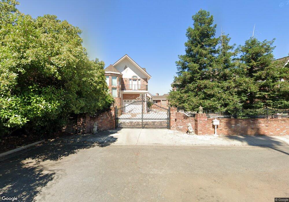
1892 Crestmont Dr Redding, CA 96002
Redding AreaEstimated Value: $954,000 - $1,661,000
About This Home
This home is located at 1892 Crestmont Dr, Redding, CA 96002 and is currently estimated at $1,397,850, approximately $199 per square foot. 1892 Crestmont Dr is a home located in Shasta County with nearby schools including Rother Elementary School, Parsons Junior High School, and Enterprise High School.
Ownership History
We collect this data history from publicly available records. To have your information removed, we recommend requesting removal directly through your county’s website.
Purchase Details
Home Financials for this Owner
Home Financials are based on the most recent Mortgage that was taken out on this home.Purchase History
We collect this data history from publicly available records. To have your information removed, we recommend requesting removal directly through your county’s website.
| Date | Buyer | Sale Price | Title Company |
|---|---|---|---|
| $685,000 | Placer Title Company |
Mortgage History
We collect this data history from publicly available records. To have your information removed, we recommend requesting removal directly through your county’s website.
| Date | Status | Borrower | Loan Amount |
|---|---|---|---|
| Open | $548,250 | ||
| Closed | $800,000 | ||
| Closed | $500,000 | ||
| Closed | $400,000 | ||
| Closed | $100,000 | ||
| Closed | $455,000 | ||
| Closed | $548,000 |
Tax History
We collect this data history from publicly available records. To have your information removed, we recommend requesting removal directly through your county’s website.
| Year | Tax Paid | Tax Assessment Tax Assessment Total Assessment is a certain percentage of the fair market value that is determined by local assessors to be the total taxable value of land and additions on the property. | Land | Improvement |
|---|---|---|---|---|
| 2025 | $13,312 | $1,250,000 | $400,000 | $850,000 |
| 2024 | $13,392 | $1,220,000 | $420,000 | $800,000 |
| 2023 | $13,392 | $1,220,000 | $420,000 | $800,000 |
| 2022 | $13,275 | $1,220,000 | $420,000 | $800,000 |
| 2021 | $13,079 | $1,220,000 | $420,000 | $800,000 |
| 2020 | $13,160 | $1,220,000 | $420,000 | $800,000 |
| 2019 | $13,315 | $1,220,000 | $420,000 | $800,000 |
| 2018 | $13,427 | $1,220,000 | $420,000 | $800,000 |
| 2017 | $13,715 | $1,200,000 | $400,000 | $800,000 |
| 2016 | $11,001 | $1,010,000 | $280,000 | $730,000 |
| 2015 | $10,945 | $998,000 | $280,000 | $718,000 |
| 2014 | $10,550 | $950,000 | $275,000 | $675,000 |
Map
- 1928 Bechelli Ln
- 1930 Bechelli Ln
- 1911 Bechelli Ln
- 1937 Bechelli Ln
- 1965 Bechelli Ln
- 1968 Bechelli Ln
- 1943 Bechelli Ln
- 1975 Bechelli Ln
- 1875 Crestmont Dr
- 1744 Bechelli Ln
- 107 Village Dr
- 2425 Beverly Dr
- 2048 Lazare Path
- 1807 Forest Glen Ct
- 1228 Cedarwood Ct
- 985 River Bend Rd
- 1026 Palisades Ave
- 965 Jamieson Ct
- 948 Jamieson Ct
- 790 Gold St
- 1919 Bechelli Ln Unit SFR
- 1919 Bechelli Ln
- 1920 Bechelli Ln Unit 1
- 1920 Bechelli Ln
- 1918 Bechelli Ln
- 1921 Bechelli Ln
- 1917 Bechelli Ln Unit The Bluffs
- 1917 Bechelli Ln
- 1922 Bechelli Ln
- 1927 Bechelli Ln
- 1916 Bechelli Ln
- 1915 Bechelli Ln
- 1923 Bechelli Ln
- 1926 Bechelli Ln
- 1925 Bechelli Ln
- 1914 Bechelli Ln
- 1929 Bechelli Ln
- 1913 Bechelli Ln
- 1912 Bechelli Ln
- 1954 Bechelli Ln
Ask me questions while you tour the home.