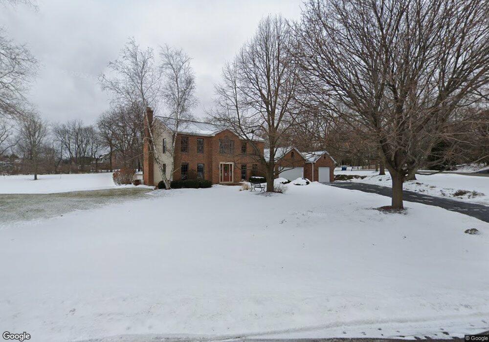
18N546 Spring Bluff Dr Dundee, IL 60118
Estimated Value: $598,000 - $759,000
5
Beds
4
Baths
3,226
Sq Ft
$200/Sq Ft
Est. Value
About This Home
This home is located at 18N546 Spring Bluff Dr, Dundee, IL 60118 and is currently estimated at $645,531, approximately $200 per square foot. 18N546 Spring Bluff Dr is a home located in Kane County with nearby schools including Liberty Elementary School, Dundee Middle School, and Harry D Jacobs High School.
Ownership History
Date
Name
Owned For
Owner Type
Purchase Details
Closed on
Jun 21, 2002
Sold by
Hansen Vernon L and Hansen Deborah A
Bought by
Hansen Vernon L and Hansen Deborah A
Current Estimated Value
Home Financials for this Owner
Home Financials are based on the most recent Mortgage that was taken out on this home.
Original Mortgage
$249,000
Interest Rate
6.8%
Purchase Details
Closed on
Jun 20, 2000
Sold by
Olson Boyd V
Bought by
Olson Boyd and Olson Diane
Create a Home Valuation Report for This Property
The Home Valuation Report is an in-depth analysis detailing your home's value as well as a comparison with similar homes in the area
Home Values in the Area
Average Home Value in this Area
Purchase History
| Date | Buyer | Sale Price | Title Company |
|---|---|---|---|
| Hansen Vernon L | -- | -- | |
| Olson Boyd | -- | -- |
Source: Public Records
Mortgage History
| Date | Status | Borrower | Loan Amount |
|---|---|---|---|
| Closed | Hansen Vernon L | $249,000 |
Source: Public Records
Tax History
| Year | Tax Paid | Tax Assessment Tax Assessment Total Assessment is a certain percentage of the fair market value that is determined by local assessors to be the total taxable value of land and additions on the property. | Land | Improvement |
|---|---|---|---|---|
| 2024 | $10,651 | $166,267 | $40,096 | $126,171 |
| 2023 | $10,047 | $149,601 | $36,077 | $113,524 |
| 2022 | $10,498 | $147,466 | $36,077 | $111,389 |
| 2021 | $10,159 | $139,237 | $34,064 | $105,173 |
| 2020 | $9,943 | $136,106 | $33,298 | $102,808 |
| 2019 | $10,331 | $137,693 | $31,610 | $106,083 |
| 2018 | $10,538 | $131,707 | $30,984 | $100,723 |
| 2017 | $9,961 | $123,206 | $28,984 | $94,222 |
| 2016 | $10,010 | $117,055 | $28,064 | $88,991 |
| 2015 | -- | $109,684 | $26,297 | $83,387 |
| 2014 | -- | $106,655 | $25,571 | $81,084 |
| 2013 | -- | $108,561 | $26,354 | $82,207 |
Source: Public Records
Map
Nearby Homes
- 3355 Blue Ridge Dr
- 3701 Blue Ridge Dr
- 3125 Shenandoah Dr
- 9 Greyshire Ct
- 1240 Glenmont St
- 2313 Barrett Dr
- 1460 Lancaster Ln
- 35W543 Miller Rd
- 1540 Westbourne Pkwy
- 1530 Westbourne Pkwy
- 1201 Waterford St
- 7344 Grandview Ct Unit 161
- 1101 Waterford St
- 1211 Waterford St
- 2224 Barrett Dr
- 1231 Waterford St
- 120 Newburgh Ln
- 2010 Cosman Way
- 0000 State Route 31
- 301 Cold Spring St
- 18N518 Spring Bluff Dr
- 18N568 Spring Bluff Dr
- 35W999 Woodhaven Ln
- 18N580 Spring Bluff Dr
- 36W031 Woodhaven Ln
- 18N507 Sleepy Hollow Ln
- 18N622 Spring Bluff Dr
- 35W699 Woodhaven Ln
- 18N611 Spring Bluff Dr
- 18N425 Sawyer Rd
- 18N423 Sawyer Rd
- 3538 Blue Ridge Ct
- 3546 Blue Ridge Ct
- 3548 Blue Ridge Ct
- 3540 Blue Ridge Ct
- 3542 Blue Ridge Ct
- 3544 Blue Ridge Ct
- 3546 Blue Ridge Ct Unit 3546
- 18N509 Sleepy Hollow Ln
- 18N617 Field Ct
Your Personal Tour Guide
Ask me questions while you tour the home.